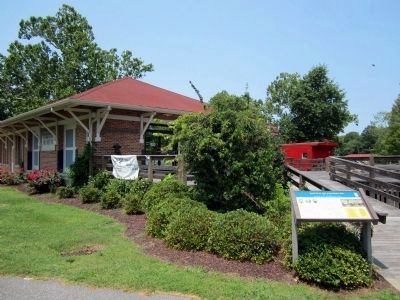
Near East Water Street at Madison Street, on the left when traveling east.
The Battle of Plymouth, April 17-20, 1864, was the last major Confederate victory of the Civil War and the third largest battle fought in North Carolina. Two North Carolinians, Gen. Robert F. Hoke and Gen. Matthew W. Ransom, led the Confederate . . . — — Map (db m56973) HM
Near East Water Street at Madison Street, on the left when traveling east.
In 1863, 19-year-old engineer Gilbert Elliott contracted with the Confederate Navy Department to construct an ironclad gunboat designed by John L. Porter, the navy’s chief architect. Elliott built the vessel at Edwards Ferry on the Roanoke River, . . . — — Map (db m56972) HM
Near East Water Street at Adams Street, on the left when traveling east.
CSS Albemarle, which had been built in a cornfield beside the Roanoke River in 1863-1864, helped drive the U.S. Army from Plymouth in April 1864 and defeated seven U.S. gunboats in May. The ironclad ram seemed invincible, but 21-year-old US. . . . — — Map (db m56975) HM
On East Main Street at Rankin Lane, on the right when traveling west on East Main Street.
Atop the hill in front of you, on the left side of the field, stood Fort Compher (also called Fort Comfort), a key position for U.S. forces occupying Plymouth. The nine-sided fortifications was named for Capt. Alexander Compher of the 101st . . . — — Map (db m76831) HM
On Dale Adams Road north of Georges Gap Road (Route 1213), on the left when traveling north.
In July 1863, Gov. Zebulon B. Vance created the Home Guard to protect communities and capture deserters, Unionists, and bushwhackers. The Guard was made up of men not liable for conscription because of age, health, and other reasons. Capt. Harvey . . . — — Map (db m100748) HM
On Old Mt. Olive Highway just south of U.S. 117, on the left when traveling south.
(Preface): Late in 1862. Union Gen. John G. Foster’s garrison was well entrenched in New Bern and made several incursions into the countryside. On December 11, Foster led a raid from New Bern to burn the Wilmington and Weldon Railroad Bridge . . . — — Map (db m28291) HM
On William Street near Mulberry Street, on the right when traveling east.
During the Civil War, Goldsboro
(then spelled Goldsborough) wa an
important railroad junction and a
vital link in the Confederate supply
chain. Here the Atlantic and North
Carolina Railroad, which ran from
Morehead City to Raleigh, . . . — — Map (db m64795) HM
On Northwest Center Street (County Route 1938) at West College Street, on the left when traveling north on Northwest Center Street.
(preface)
Late in 1862, Union Gen. John G. Foster’s garrison was well entrenched in New Bern and made several incursions into the countryside. On December 11, Foster led a raid from New Bern to burn the Wilmington and Weldon Railroad Bridge . . . — — Map (db m77311) HM
On West River Street at New Street, on the right when traveling west on West River Street.
(Preface): Late in 1862, Union Gen. John G. Foster's garrison was well entrenched in New Bern and made several incursions into the countryside. On December 11, Foster led a raid from New Bern to burn the Wilmington and Weldon Railroad Bridge . . . — — Map (db m30540) HM
On Recreation Road, on the right when traveling east.
The site of Fort Hamby is located about half a mile south of here. The two-story log house was not a military fortification. It got its name after 20 to 30 Union and Confederate deserters occupied it at the end of the war. Their leader, who gave his . . . — — Map (db m55373) HM
On Goldsboro Street East at Lee Street East on Goldsboro Street East.
This is the only known surviving portion of one of Wilson's earliest school buildings, the Wilson Female Academy, which also served as a Confederate hospital during the war. Wilson's location on the Wilmington & Weldon Railroad, the principal . . . — — Map (db m226842) HM
On Windsor Road at Buck Shoals Road, on the right on Windsor Road.
(Preface):
On March 24, 1865, Union Gen. George Stoneman led 6,000 cavalrymen from Tennessee into southwestern Virginia and western North Carolina to disrupt the Confederate supply line by destroying sections of the Virginia and Tennessee . . . — — Map (db m55343) HM
On Courtney-Hunstville Road at Farmington Road, on the left on Courtney-Hunstville Road.
[Preface]:
On March 24, 1865, Union Gen. George Stoneman led 6,000 cavalrymen from Tennessee into southwestern Virginia and western North Carolina to disrupt the Confederate supply line by destroying sections of the Virginia and Tennessee . . . — — Map (db m54678) HM
On Winston Road (State Highway 67) north of Fall Creek Church Road, on the right when traveling west.
(Preface):
On March 24, 1865, Union Gen. George Stoneman led 6,000 cavalrymen from Tennessee into southwestern Virginia and western North Carolina to disrupt the Confederate supply line by destroying sections of the Virginia and Tennessee . . . — — Map (db m56801) HM
Richmond Hill was the home of North Carolina Supreme Court Chief Justice Richmond Mumford Pearson (1805-1878) and his family. Pearson conducted a law school from 1848 to 1878 in a small building located west of this house. Students lived in log . . . — — Map (db m54600) HM
On Deep Creek Church Road, on the right when traveling east.
On February 12, 1863, a cold, snowy day, an odd fellowship of sixteen men huddled in the little schoolhouse that stood behind Deep Creek Friends Meetinghouse. Several, including brothers Jesse and William Dobbins (the latter a fugitive from jail), . . . — — Map (db m54672) HM
On Van Buren Street at Hemlock Avenue, on the right when traveling north on Van Buren Street.
Secession and war divided Yadkin County residents as well as other western North Carolians, and the neighbor and families quickly came to blows. Confederate conscription acts fostered resistance, the mountains sheltered deserters from both sides, . . . — — Map (db m54673) HM
Burnsville exemplified western North Carolinians’ divided loyalties. Yancey County was evenly split on the secession issue. In January 1861, secession advocates in the town square burned an effigy of Cong. Zebulon B. Vance, who advised caution in . . . — — Map (db m77455) HM
218 entries matched your criteria. Entries 201 through 218 are listed above. ⊲ Previous 100