On U.S. 158/301 north of Sycamore Street, on the left when traveling north.
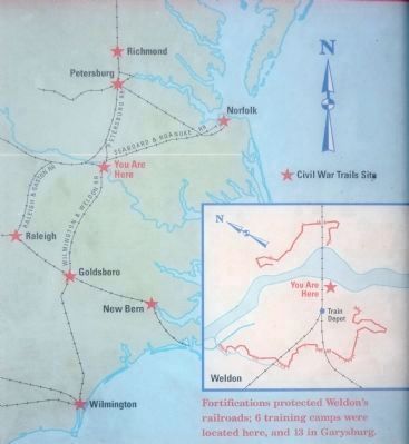
Located on the Roanoke River, the town of Weldon was one of the South's major transportation hubs at the beginning of the Civil War. By 1861, the town served as an important stop for steamboats and canal boats, and it was the junction of the . . . — — Map (db m222108) HM
On McLellon Road (State Highway 82) south of Arrowhead Road, on the right when traveling south.
Preface: The Carolinas Campaign began on February 1, 1865, when Union Gen. William T. Sherman led his army north from Savannah, Georgia, after the “March to the Sea.” Sherman's objective was to join Gen. Ulysses S. Grant in Virginia to crush . . . — — Map (db m3741) HM
On Norma Drive at Longbranch Road, on the left when traveling south on Norma Drive. Reported damaged.
(Preface):The Carolinas Campaign began on February 1, 1865, when Union Gen. William T. Sherman led his army north from Savannah, Georgia, after the “March to the Sea.” Sherman’s objective was to join Gen. Ulysses S. Grant in Virginia to crush . . . — — Map (db m160759) HM
On Harnett-Dunn Highway (U.S. 55) at Paul Green Memorial Highway (North Carolina Highway 421), on the left when traveling east on Harnett-Dunn Highway. Reported damaged.
(Preface): The Carolinas Campaign began on February 1, 1865, when Union Gen. William T. Sherman led his army north from Savannah, Georgia, after the “March to the Sea.” Sherman’s objective was to join Gen. Ulysses S. Grant in Virginia to . . . — — Map (db m210968) HM
On State Highway 82 south of Arrowhead Road, on the left when traveling north.
North Carolina's Civil War stories are as diverse as its landscape. The Outer Banks and coastal rivers saw action early in the war, as Union forces occupied the region. Stories abound of naval battles, blockade running, Federal raids, and the . . . — — Map (db m210219) HM
On Locust Street at Pennsylvania Avenue, on the left when traveling south on Locust Street.
The first Locust Old Fields Baptist Church was established here in 1803. It was among the first churches established west of Asheville. Although the original building no longer stands, it served the small community here for many years as a house of . . . — — Map (db m75504) HM
On February 1, 1865, Col. George Kirk, 2nd North Carolina Mounted Infantry (U.S.), left Newport, Tennessee, with 400 cavalry and 200 infantry for a raid into Haywood County. He passed through the mountains at Mount Sterling, following the . . . — — Map (db m12895) HM
Until it was demolished in 1899, the Battle House, a stagecoach house and inn, stood just to your left.
There, on May 7, 1865, a proposed Union surrender was transformed into a Confederate capitulation.
After Col. William C. Bartlett's 2nd N.C. . . . — — Map (db m12892) HM
On Hillview Circle east of South Main Street (Business U.S. 23), on the left when traveling south.
Col. William Holland Thomas (February 5, 1805-May 10, 1893) is among the Confederate officers and soldiers buried here in Greenhill Cemetery. His grave is located about thirty yards in front of you on the right.
Thomas, who began trading with . . . — — Map (db m75487) HM
On Timothy Lane, 0.1 miles west of Blink Bonny Drive, on the right when traveling west.
Col. William C. Bartlett’s 2nd N.C. Mounted Infantry (U.S.) occupied Waynesville early in May 1865. The Federals raided the surrounding countryside, relieving civilians of their horses and provisions.
On May 6, a company of Confederate Col. . . . — — Map (db m75490) HM
On East Main Street at South Wynn Street, on the right when traveling east on East Main Street.
Murfreesboro, a prosperous riverfront commercial center, interested both sides during the war. In June 1862, Confederate Gen. Theophilus H. Holmes ordered cotton destroyed here and in other nearby towns. Eighty Confederate cavalrymen executing his . . . — — Map (db m43434) HM
On King Street, 0.1 miles Tryon Street, on the left when traveling north.
After Union Gen. Ambrose E. Burnside captured Roanoke Island in February 1862, he decided to "sweep Albemarle Sound clean of [Confederate] defenses," establish inland bases of operation, and encourage eastern North Carolina Unionists. Winton, the . . . — — Map (db m43431) HM
On Center Street, on the left when traveling south.
(Preface):
On March 24, 1865, Union Gen. George Stoneman led 6,000 cavalrymen from Tennessee into southwestern Virginia and western North Carolina to disrupt the Confederate supply line by destroying sections of the Virginia and Tennessee . . . — — Map (db m57089) HM
Near State Highway 107, 0.2 miles south of Whiteside Cove Road (County Route 1107), on the right when traveling south.
The Zachary family of Cashiers symbolizes the divided loyalties of western North Carolinians. The builder of this house, Mordecai Zachery, had strong ties to the Confederacy, as did others in the area. Confederate Gen. Wade Hampton sent his family . . . — — Map (db m75476) HM
On South O'Neil Street at West 2nd Street, on the right when traveling north on South O'Neil Street.
(preface) The Carolina Campaign began on February 1, 1865, when Union Gen. William T. Sherman led his army north from Savannah, Georgia, after the March to the Sea. Sherman’s objective was to join Gen. Ulysses S. Grant in Virginia . . . — — Map (db m217462) HM
On Harper House Road (County Route 1008) at Mill Creek Church Road (County Route 1188), on the left when traveling north on Harper House Road.
(Preface): The Carolinas Campaign began on February 1, 1865, when Union Gen. William T. Sherman led his army north from Savannah, Georgia, after the “March to the Sea.” Sherman's objective was to join Gen. Ulysses S. Grant in Virginia . . . — — Map (db m222866) HM
On Harper House Road (County Route 1008) 0.2 miles east of Mill Creek Church Road (Route 1188), on the left when traveling east.
General Johnston's Military Career
Named after Captain Joseph Eggleston, under whom his father Peter Johnston served in Lighthorse Harry Lee's Legion during the Revolutionary War, General Joseph Eggleston Johnston was born February 3, 1807 . . . — — Map (db m222968) HM
On Stewart Road (State Highway 1009) at Stewart Road (Highway 1179), on the left when traveling north on Stewart Road.
(Preface): The Carolinas Campaign began on February 1, 1865, when Union Gen. William T. Sherman led his army north from Savannah, Georgia, after the “March to the Sea.” Sherman's objective was to join Gen. Ulysses S. Grant in Virginia to . . . — — Map (db m222967) HM
On Devils Racetrack Road, on the right when traveling north.
(Preface): The Carolinas Campaign began on February 1, 1865, when Union Gen. William T. Sherman led his army north from Savannah, Georgia, after the “March to the Sea.” Sherman's objective was to join Gen. Ulysses S. Grant in Virginia to . . . — — Map (db m222966) HM
On Bass Road (County Route 1008) at Bass Road (County Route 1194), on the left when traveling east on Bass Road.
(Preface):The Carolinas Campaign began on February 1, 1865, when Union Gen. William T. Sherman led his army north from Savannah, Georgia, after the “March to the Sea.” Sherman's objective was to join Gen. Ulysses S. Grant in Virginia to crush . . . — — Map (db m222921) HM
On Devils Racetrack Road (State Highway 1009), on the right when traveling north.
(Preface):The Carolinas Campaign began on February 1, 1865, when Union Gen. William T. Sherman led his army north from Savannah, Georgia, after the “March to the Sea.” Sherman's objective was to join Gen. Ulysses S. Grant in Virginia to . . . — — Map (db m222962) HM
On Buffalo Road at Old Beulah Road, on the right when traveling north on Buffalo Road.
(preface)
The Carolinas Campaign began on February 1, 1865, when Union Gen. William T. Sherman led his army north from Savannah, Georgia, after the March to the Sea. Sherman’s objective was to join Gen. Ulysses S. Grant in Virginia to crush . . . — — Map (db m222841) HM
On U.S. 301 north of Carroll Drive, on the right when traveling north.
(Preface): The Carolinas Campaign began on February 1, 1865, when Union Gen. William T. Sherman led his army north from Savannah, Georgia, after the “March to the Sea.” Sherman's objective was to join Gen. Ulysses S. Grant in . . . — — Map (db m222858) HM
On South Front Street at East Johnston Street, on the left when traveling north on South Front Street.
The Carolinas Campaign began on February 1, 1865, when Union Gen. William T. Sherman led his army north from Savannah, Georgia, after the “March to the Sea.” Sherman's objective was to join Gen. Ulysses S. Grant in Virginia to crush Gen. . . . — — Map (db m217504) HM
On East Market Street (Business U.S. 70) at South 2nd Street, on the right when traveling east on East Market Street.
(Preface) The Carolinas Campaign began on February 1, 1865, when Union Gen. William T. Sherman led his army north from Savannah, Georgia, after the “March to the Sea.” Sherman's objective was to join Gen. Ulysses S. Grant in . . . — — Map (db m222854) HM
On Richlands Road (U.S. 258) at Stroud's Corner Road on Richlands Road.
The yellow sidebar in the upper left provides a brief background: Late in 1862, Union Gen. John G. Foster’s garrison was well entrenched in New Bern and made several incursions into the countryside. On December 11, Foster led a raid from New . . . — — Map (db m23655) HM
On South Queen Street (U.S. 258) at East New Bern Road (U.S. 70), on the right when traveling north on South Queen Street.
(Preface): Late in 1862, Union Gen. John G. Foster's garrison was well entrenched in New Bern and made several incursions into the countryside. On December 11, Foster led a raid from New Bern to burn the Wilmington and Weldon Railroad Bridge . . . — — Map (db m30526) HM
On Meadowbrook Drive at Harriette Drive, on the right when traveling north on Meadowbrook Drive.
(Preface): Late in 1862, Union Gen. John G. Foster's garrison was well entrenched in New Bern and made several incursions into the countryside. On December 11, Foster led a raid from New Bern to burn the Wilmington and Weldon Railroad Bridge . . . — — Map (db m30529) HM
On New Bern Road (U.S. 70) at Woodmen Way on New Bern Road.
The yellow sidebar in the upper left of the marker provides a brief synopsis of the Carolinas Campaign. It states:
The Carolinas Campaign began on February 1, 1865, when Union Gen. William T. Sherman led his army north from Savannah, . . . — — Map (db m23802) HM
On South Heritage Street at West Caswell Street, on the right when traveling south on South Heritage Street.
The Confederate ironclad ram Neuse was constructed at Whitehall (present-day Seven Springs) beginning in October 1862. In March 1863, having survived Union Gen. John G. Foster's raid and the engagement at Whitehall the pervious December, . . . — — Map (db m30533) HM
On New Bern Road (U.S. 70) near Neuse Road (North Carolina Highway 1804).
At this location was the site of the Howard House, used as Confederate Headquarters during the Battle of Wyse Fork, March 8-10, 1865. General Braxton Bragg commanded the Confederate Army that was composed of the forces of Major General D.H. Hill and . . . — — Map (db m23745) HM
On Richard Caswell Grave Road at West Vernon Avenue (U.S. 70/258), on the right when traveling east on Richard Caswell Grave Road. Reported permanently removed.
The Confederate ironclad ram Neuse was constructed at Whitehall (present-day Seven Springs) beginning in October 1862. The unfinished hull survived the fighting there during Union Gen. John G. Foster's raid in December of 1863. It was docked . . . — — Map (db m153658) HM
On Richlands Road (U.S. 258) 0.2 miles south of New Bern Road (U.S. 70), on the right when traveling north.
The yellow sidebar in the upper left provides a brief background: Late in 1862, Union Gen. John G. Foster’s garrison was well entrenched in New Bern and made several incursions into the countryside. On December 11, Foster led a raid from New . . . — — Map (db m23656) HM
On East New Bern Road (U.S. 70) at Richlands Road (U.S. 258), on the right when traveling east on East New Bern Road.
North Carolina's Civil War stories are as diverse as its landscape. The Outer Banks and coastal rivers saw action early in the war, as Union forces occupied the region. Stories abound of naval battles, blockade running, Federal raids, and the . . . — — Map (db m30518) HM
On Old Plank Road at Hines Circle Road, on the right when traveling west on Old Plank Road.
Near here stood Cottage Home, the farmhouse of the Rev. Robert Hall Morrison, a Presbyterian minister and one of the founders of Davidson College. He and his wife, Mary Graham, had ten children; three of their daughters married men who later become . . . — — Map (db m70034) HM
On West Main Street (State Highway 28) east of Macon Avenue, on the right when traveling west.
Here stood Dixie Hall, the home of prosperous local merchant Julius T. Siler. A landowner and slaveholder. Siler joined the Confederate army along with about 3,000 other Macon County men and served as the captain of Company E, 6th North Carolina . . . — — Map (db m75472) HM
On West Main Street (Business U.S. 441) east of Macon Avenue.
Confederate Col. William H. Thomas organized Thomas’s Legion of Cherokee Indians and Mountaineers is western North Carolina in September 1862. The people of this area were sometime referred to as highlanders, and local residents called Thomas’s unit . . . — — Map (db m75455) HM
On October 17, 1863, Union Gen. Ambrose E. Burnside reported from Knoxville, Tennessee, that "a regiment of North Carolina troops we are now organizing here yesterday captured Warm Springs, N.C., and now hold Paint Rock Gap." This regiment, the 2nd . . . — — Map (db m23687) HM
Baptist farm families here established Mars Hills College in 1856. The four-acre college campus had three structures by 1861: a two-story brick classroom building, a frame dormitory for boys, and a frame teachers' residence. They stood about 75 . . . — — Map (db m23140) HM
On South Main Street (Business U.S. 70) west of Hill Street, on the left when traveling east.
On May 13, 1861, voters gathered here in Marshall, the Madison County seat, to elect a delegate for the Secession Convention to be held in Raleigh. The citizens were divided in their loyalties. Sheriff Ransom P. Merrill and others were later . . . — — Map (db m75592) HM
On Fort Branch Road (County Route 1416), on the right when traveling east.
At the beginning of the Civil War, the Confederates fortified the high bluffs of Rainbow Banks here on the Roanoke River. The fort helped prevent Union gunboat attacks in the upper Roanoke River Valley, guarded the Wilmington and Weldon Railroad . . . — — Map (db m59063) HM
On East Church Street at North Smithwick Street, on the left when traveling east on East Church Street.
Asa Biggs (1811-1878), a prominent North Carolina politician and jurist, and his wife, Martha, built this Federal and Greek Revival—style house and lived here from 1835 to 1862. Biggs practiced law from his office just across Smithwick Street. . . . — — Map (db m152853) HM
Near U.S. 70, 0.2 miles east of Lake Tahoma Road (North Carolina Highway 80), on the right when traveling east.
(preface)
On March 24, 1865, Union Gen. George Stoneman led 6,000 cavalrymen from Tennessee into southwestern Virginia and western North Carolina to disrupt the Confederate supply line by destroying sections of the Virginia and Tennessee . . . — — Map (db m208799) HM
Near Fort Fisher Boulevard South (U.S. 421) 1.4 miles south of Loggerhead Road.
These are the remnants of Battery Buchanan, named for Confederate Adm. Franklin Buchanan. It was constructed in 1864 to guard this point and also to serve as “a citadel to which an overpowered garrison might retreat.” It was the last . . . — — Map (db m28637) HM
Here, in the earthworks in front of you, Confederate Gen. Robert F. Hoke’s troops made a stand on February 20-21, 1865. They were attempting to halt the Union army’s advance on Wilmington, the Confederacy’s principal seaport. Blockade runners, . . . — — Map (db m28636) HM
On Boones Mill Road (U.S. 158) 0.5 miles west of Barrows Mill Road, on the left when traveling east. Reported permanently removed.
On July 28, 1863, Union Col. Samuel P. Spear's cavalrymen came thundering through Jackson from Federal-occupied Winton to destroy the Wilmington and Weldon Railroad Bridge over the Roanoke River at Weldon. Confederate Gen. Matt W. Ransom and his . . . — — Map (db m43394) HM
On Boones Mill Road (County Road 1137) 0.1 miles east of U.S. 158, on the right when traveling east.
On July 28, 1863, some of Confederate Gen. Matt W. Ransom's men were bathing here in the Boone's Mill pond, when suddenly bullets began splashing into the water. At the same time, Ransom and his staff galloped across the mill bridge shouting . . . — — Map (db m180511) HM
Near Fla Camp Road, 0.4 miles west of Hammock Beach Road, on the left when traveling west.
Union Gen. Benjamin F. Butler’s capture of Hatteras Inlet in August 1861 gave Federal forces a foothold from which they could launch attacks up the rivers and sounds of eastern North Carolina. Confederate authorities decided to construct earthen . . . — — Map (db m168280) HM
On East King Street at South Cameron Street, on the right when traveling east on East King Street.
The Alexander Dickson House, an ideal example of 18th-century "Quaker-plan" farmhouse, was built around 1790. Alexander Dickson, his wife, Elizabeth, and their nine children moved into this house in 1845. In addition to running the farm, Dickson . . . — — Map (db m139748) HM
Near State Highway 86, on the right when traveling south.
(Preface, upper left): The Carolinas Campaign began on February 1, 1865, when Union Gen. William T. Sherman led his army north from Savannah, Georgia, after the “March to the Sea.” Sherman’s objective was to join Gen. Ulysses S. . . . — — Map (db m13972) HM
On North Poindexter Street at East Cypress Street, on the right when traveling north on North Poindexter Street.
(preface)
During the Civil War, neither the North nor the South was totally united over the key issues. Just as some Northerners supported slavery and secession, some Southerners were abolitionist and Unionists. These issues could split . . . — — Map (db m56765) HM
On East Main Street at North Elliot Street, on the right when traveling east on East Main Street.
During the Civil War, neither the North nor the South was totally united over the key issues. Just as some Northerners supported slavery and secession, some Southerners were abolitionist and Unionists. These issues could split families, . . . — — Map (db m56770) HM
On East Colonial Avenue at North Elliot Street, on the left when traveling east on East Colonial Avenue.
(preface)
During the Civil War, neither the North nor the South was totally united over the key issues. Just as some Northerners supported slavery and secession, some Southerners were abolitionist and Unionists. These issues could split . . . — — Map (db m56797) HM
On East Colonial Avenue at North Elliot Street, on the left when traveling east on East Colonial Avenue.
(preface)
During the Civil War, neither the North nor the South was totally united over the key issues. Just as some Northerners supported slavery and secession, some Southerners were abolitionist and Unionists. These issues could split . . . — — Map (db m56799) HM
Near South Water Street at East Ehringhaus Street, on the left when traveling south.
(sidebar)
During the Civil War, neither the North nor the South was totally united over the key issues. Just as some Northerners supported slavery and secession, some Southerners were abolitionist and Unionists. These issues could split . . . — — Map (db m56809) HM
Near South Water Street at East Ehringhaus Street, on the left when traveling south.
After Union Gen. Ambrose E. Burnside captured Roanoke Island on February 8, 1862, he dispatched Commander Stephen C. Rowan to destroy the Mosquito Fleet, which had been annoying U.S. naval vessels. Confederate Commodore William F. Lynch’s fleet . . . — — Map (db m56812) HM
On South Dickerson Street (County Route 1412) at West Wilmington Street (North Carolina Highway 53), on the right when traveling south on South Dickerson Street.
Burgaw Station, a stop on the Wilmington and Weldon Railroad, was located on the rail line known as the “Lifeline of the Confederacy,” Gen. Robert E. Lee’s main supply route for his Army of Northern Virginia by 1864. This rail line transported . . . — — Map (db m191883) HM
On Hyde Park Street at King Street, on the right when traveling south on Hyde Park Street.
News of the bombardment of Fort Sumter inspired many African American men to rnlist in the U.S. armed forces, but federal law prohibited their service. Frederick Douglass and other black leaders urged changes to allow black enlistments. By mid-1862, . . . — — Map (db m84932) HM WM
On Ayden Golf Club Road north of Hines Drive Extension, on the left when traveling north.
A hero of the fight for Fort Fisher is buried here in the churchyard. Pvt. Christopher C. “Kit” Bland, Battery K, 2nd North Carolina Artillery, was serving at the fort, the “Gibraltar of the Confederacy,” when Federal forces . . . — — Map (db m70453) HM
On Black Jack-Simpson Road at Spencer Loop Road, on the left when traveling south on Black Jack-Simpson Road.
(preface)
On July 18, 1863, Union Gen. Edward E. Potter led infantry and cavalry from New Bern to destroy the Wilmington and Weldon Railroad bridge at Rocky Mount. The infantry feinted toward Kinston and returned to New Bern. Potter raided . . . — — Map (db m76907) HM
On South Main Street (State Highway 43) 0.3 miles south of West Avenue (State Highway 222), on the right when traveling south.
On July 18, 1863, Union Gen. Edward E. Potter led infantry and cavalry from New Bern to destroy the Wilmington and Weldon Railroad bridge at Rocky Mount. The infantry feinted toward Kinston and returned to New Bern. Potter raided . . . — — Map (db m76871) HM
On South Main Street (Business U.S. 258) at West Pine Street, on the right when traveling south on South Main Street.
(preface)
On July 18, 1863, Union Gen. Edward E. Potter led infantry and cavalry from New Bern to destroy the Wilmington and Weldon Railroad bridge at Rocky Mount. The infantry feinted toward Kinston and returned to New Bern. Potter raided . . . — — Map (db m76874) HM
Near East 1st Street at North Side Street, on the left when traveling east.
(preface)
On July 18, 1863, Union Gen. Edward E. Potter led infantry and cavalry from New Bern to destroy the Wilmington and Weldon Railroad bridge at Rocky Mount. The infantry feinted toward Kinston and returned to New Bern. Potter raided . . . — — Map (db m76873) HM
On East Fire Tower Road at Eleanor Street, on the right when traveling west on East Fire Tower Road.
Federal expeditions frequently disrupted Confederate activities late in 1863. Union forces often assembled here at Red Banks Church because it was near Confederate camps. On December 17, 1863, a Federal attack near here on the camp of Co. H, 3rd . . . — — Map (db m70496) HM
On Cannon Price Road at Stokestown Saint Johns Road (County Route 1753), on the right when traveling east on Cannon Price Road.
(preface)
On July 18, 1863, Union Gen. Edward E. Potter led infantry and cavalry from New Bern to destroy the Wilmington and Weldon Railroad bridge at Rocky Mount. The infantry feinted toward Kinston and returned to New Bern. Potter raided . . . — — Map (db m76919) WM
On County Home Road at Ivy Road, on the left when traveling north on County Home Road.
After Union forces occupied New Bern in March 1862, Confederate Maj. John N. Whitford established a camp here at Haddocks Crossroads, the intersection of the main roads from Greenville to New Bern and to Kinston. Whitford’s Battalion of Partisan . . . — — Map (db m70459) HM
(Preface): On March 24, 1865, Union Gen. George Stoneman led 6,000 cavalrymen from Tennessee into southwestern Virginia and western North Carolina to disrupt the Confederate supply line by destroying sections of the Virginia and Tennessee . . . — — Map (db m53199) HM
On State Highway 62 at Trinity College Road, on the right when traveling south on State Highway 62.
(Preface, upper left): The Carolinas Campaign began on February 1, 1865, when Union Gen. William T. Sherman led his army north from Savannah, Georgia, after the “March to the Sea.” Sherman’s objective was to join Gen. . . . — — Map (db m58259) HM
On Moncure Street at Henry Street, on the left when traveling east on Moncure Street.
Anne “Annie” Eliza Johns, volunteer nurse, poet, teacher, and author of Cooleemee, A Tale of Southern Life, is buried here with her family in the Church of the Epiphany Cemetery. She was born in Pittsylvania Co.,Va., on July 16, . . . — — Map (db m63047) HM
On S Hamilton Street near North Carolina Highway Old 87, on the left when traveling north.
The Roanoke Navigation Company opened the upper Dan River here for batteau traffic in the 1820s, and the towns of Leaksville (present-day Eden) and Madison became river ports. During the antebellum era, farmers shipped their produce downstream to . . . — — Map (db m63043) HM
On Church Street (State Highway 700) east of Morgan Road, on the left when traveling west.
Former Gov. John Motley Morehead built the Leaksville cotton factory here in 1839. Water from the nearby Smith River rapids powered the stone mill. In May and June 1861, the factory furnished 1,700 yards of osnaburg (a coarse, strong cloth . . . — — Map (db m63044) HM
On W Academy Street (State Highway 704) at S Franklin Street, on the right when traveling east on W Academy Street.
Alfred M. Scales was born on November 26, 1827, in eastern Rockingham County. After attending Caldwell Institute in Greensboro and the University of North Carolina, he read law under Judge William H. Battle, then settled in Madison and opened his . . . — — Map (db m62981) HM
On SE Market Street at Lawsonville Avenue, on the left when traveling south on SE Market Street.
The Piedmont Railroad, chartered in 1862, linked Danville, Virginia, with Greensboro, North Carolina. Work began on the road that autumn in Danville, but wartime labor and supply shortages impeded progress on the 48-mile-long line, which did not . . . — — Map (db m63046) HM
On State Highway 65 at Tyre Dodson Road, on the right when traveling east on State Highway 65.
When the Civil War began in 1861, the courthouse village of Wentworth contained a few hundred people as well as county buildings, law offices, several stores, two churches, two hotels, a school, a Masonic Hall, a tavern, a carriage factory, and two . . . — — Map (db m63041) HM
On State Highway 65 at Hearthstone Trail, on the right when traveling east on State Highway 65.
Wentworth Methodist Church was organized in 1836, and the present sanctuary was constructed in 1859. It contains a slave gallery and is the last antebellum Methodist church building in Rockingham County. It was listed on the National Register of . . . — — Map (db m63042) HM
On E Bank Street, on the right when traveling north.
On November 2, 1861, the Confederate government purchased about 16 acres here for a prison. The tract included an abandoned three-story cotton mill, a boiler house, six tenements, a superintendent’s house, and several smaller buildings. A stockade . . . — — Map (db m34202) HM
On S Jackson Street, on the left when traveling north.
In 1859, Dr. Josephus Wells Hall bought this house, which was constructed in 1820 as the Salisbury Female Academy, and added a new entrance and the double veranda with lacey ironworks. Inside, he had ornate French wallpaper hung and the hall . . . — — Map (db m34279) HM
On N Main Street (U.S. 29) at W Council Street, on the left when traveling north on N Main Street.
The Old Rowan County Courthouse, a visible reminder of Salisbury’s antebellum prosperity, was erected in 1855 and is one of North Carolina’s finest Greek Revival-style public buildings. It served as Rowan’s third courthouse until 1914. Salisbury . . . — — Map (db m34278) HM
On March 24, 1865, Union Gen. George Stoneman led 6,000 cavalrymen from Tennessee into southwestern Virginia and western North Carolina to disrupt the Confederate supply line by destroying sections of the Virginia and Tennessee Railroad, the . . . — — Map (db m12890) HM
On Coxe Road (County Route 1005) 0.4 miles east of River Crest Parkway, on the left when traveling east.
(preface)
On March 24, 1865, Union Gen. George Stoneman led 6,000 cavalrymen from Tennessee into southwestern Virginia and western North Carolina to disrupt the Confederate supply line by destroying sections of the Virginia and Tennessee . . . — — Map (db m208801) HM
(Preface): On March 24, 1865, Union Gen. George Stoneman led 6,000 cavalrymen from Tennessee into southwestern Virginia and western North Carolina to disrupt the Confederate supply line by destroying sections of the Virginia and Tennessee . . . — — Map (db m34075) HM
On Old Wire Road (State Highway 144) west of Crest Mill Road, on the left when traveling west.
(preface)
The Carolinas Campaign began of February 1, 1865, when Union Gen. William T. Sherman led his army north from Savannah, Georgia, after the March to the Sea. Sherman's objective was to join Gen. Ulysses S. Grant in Virginia to . . . — — Map (db m77356) HM
On Church Street (Business U.S. 74) at Main Street (U.S. 15/501), on the left when traveling east on Church Street.
Preface:
The Carolinas Campaign began on February 1, 1865, when Union Gen. William T. Sherman led his army north from Savannah, Georgia, after the March to the Sea. Sherman's objective was to join Gen. Ulysses S. Grant in Virginia to crush . . . — — Map (db m56192) HM
On McFarland Road at Laurel Hill Church Road, on the right when traveling west on McFarland Road.
(preface)
The Carolina Campaign began on February 1, 1865, when Union Gen. William T. Sherman led his army north from Savannah, Georgia, after the March to the Sea. Sherman’s objective was to join with Gen. Ulysses S. Grant in Virginia to . . . — — Map (db m121982) HM
On Harry Malloy Road at Stewartsville Cemetary Road, on the left when traveling east on Harry Malloy Road.
Preface:
The Carolinas Campaign began on February 1, 1865, when Union Gen. William T. Sherman led his army north from Savannah, Georgia, after the March to the Sea. Sherman's objective was to join Gen. Ulysses S. Grant in Virginia to crush . . . — — Map (db m56312) HM
Near Spring Hill Road north of Old Wire Road (North Carolina Highway 144), on the right when traveling north.
(preface)
The Carolinas Campaign began on February 1, 1865, when Union Gen. William T. Sherman led his army north from Savannah, Georgia, after the March to the Sea. Sherman’s objective was to join Gen. Ulysses S. Grant in Virginia to crush . . . — — Map (db m70350) HM
On Courthouse Circle at Main Street (North Carolina Highway 8/89), on the left when traveling north on Courthouse Circle.
Early in April 1865, Union Gen. George Stoneman’s cavalry moved from Tennessee into Virginia and then south through Danbury to destroy railroad track, warehouses, and supplies that supported Gen. Robert E. Lee’s Army of Northern Virginia. Stoneman . . . — — Map (db m77678) HM
Near Shepherd Mill Road, on the right when traveling east.
During the Civil War, the Confederacy relied on small rural ironworks for the metals needed to manufacture cannons, swords, and firearms. The furnace here, owned by the Moratock Mining and Manufacturing Company, was typical of the charcoal blast . . . — — Map (db m34156) HM
On Main Street at Front Street, on the left when traveling east on Main Street.
(Preface):
On March 24, 1865, Union Gen. George Stoneman led 6,000 cavalrymen from Tennessee into southwestern Virginia and western North Carolina to disrupt the Confederate supply line by destroying sections of the Virginia and Tennessee . . . — — Map (db m56794) HM
On Rockford Road, on the right when traveling south.
(Preface):
On March 24, 1865, Union Gen. George Stoneman led 6,000 cavalrymen from Tennessee into southwestern Virginia and western North Carolina to disrupt the Confederate supply line by destroying sections of the Virginia and Tennessee . . . — — Map (db m54626) HM
On March 24, 1865, Union Gen. George Stoneman led 6,000 cavalrymen from Tennessee into southwestern Virginia and western North Carolina to disrupt the Confederate supply line by destroying sections of the Virginia and Tennessee Railroad, . . . — — Map (db m54615) HM
On Asheville Highway (State Highway 280) 0.2 miles north of Pisgah Highway (U.S. 276), on the left when traveling north.
This was the home of William Deaver and his wife, Margaret Patton Deaver. It was the scene of a tragic shooting in February 1865, a consequence of the tumult that the Civil War created among North Carolinians.
When the war began, a few . . . — — Map (db m75478) HM
Near Magnolia Road (County Route 1118) 0.3 miles south of Lake Shore Road, on the left when traveling south.
James Johnston Pettigrew was born here at Bonarva on July 4, 1828. His father, Ebenezer Pettigrew, operated several large plantations in Tyrell and Washington Counties. Johnston Pettigrew, as he was called, graduated in 1847 from the University of . . . — — Map (db m76822) HM
On Brady Road at Bigham Road, on the left when traveling west on Brady Road.
(preface):
The Carolinas Campaign began on February 1, 1865, when Union Gen. William T. Sherman led his army north from Savannah, Georgia, after the “March to the Sea.” Sherman’s objective was to join Gen. Ulysses S. Grant in . . . — — Map (db m220543) HM
On North Chavis Road, on the left when traveling east.
Fifty-four Confederate soldiers from Georgia, North Carolina, South Carolina, and Virginia are buried here. They died at General Hospital Number One, Kittrell Springs in the former Kittrell Springs Hotel owned by Maj. Charles C. Blacknall and his . . . — — Map (db m222000) HM
Near Town Hill Drive at Morrisville Carpenter Road, on the right when traveling north.
(preface)
The Carolina Campaign began on February 1, 1865, when Union Gen. William T. Sherman led his army north from Savannah, Georgia, after the March to the Sea. Sherman’s objective was to join Gen. Ulysses S. Grant in Virginia to . . . — — Map (db m77704) HM
On E Edenton Street, on the right when traveling west.
North Carolina’s Civil War stories are as diverse as its landscape. The Outer Banks and coastal rivers saw action early in the war, as Union forces occupied the region. Stories abound of naval battles, blockade running, Federal raids and the . . . — — Map (db m63218) HM
On Edenton Street, on the right when traveling west.
( Preface : ) The Carolinas Campaign began on February 1, 1865, when Union Gen. William T. Sherman led his army north from Savannah, Georgia, after the March to the Sea. Sherman’s objective was to join Gen. Ulysses S. Grant in Virginia . . . — — Map (db m63150) HM
On Hillsborough Street west of St. Mary’s Street, on the right when traveling west.
Here in this oak grove on the front campus of Saint Mary’s School for girls, Union Gen. Oliver O. Howard, commanding Gen. William T. Sherman’s Right Wing, encamped in April 1865. The Federals coexisted with students and faculty for several weeks, . . . — — Map (db m63152) HM
On East Third Street at Washington Street, on the left when traveling east on East Third Street.
Bullet holes around the upstairs window of the Ausbon House are haunting reminders of a fight to the death here on December 10, 1862, when a Confederate sniper refused to surrender. Hoping to drive out the U.S. forces occupying Plymouth then, Lt. . . . — — Map (db m56977) HM