English
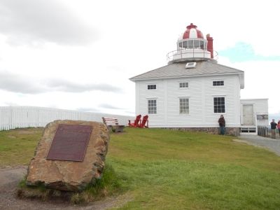
Cape Spear, Newfoundland’s oldest surviving lighthouse, has served as the chief approach light for St. John’s harbour since 1836. Constructed by local builders Nicholas Croke and William Parker, it consists of a stone towner . . . — — Map (db m79112) HM
On Newfoundland and Labrador Route 10, on the left when traveling north.
A “Fishing Capital” and Colony
This was one of the first harbours in the New World to be frequented by European fishing ships. From the early 1500s The Pool was well known to the Portuguese, Spanish and French fleets. . . . — — Map (db m79471) HM
Captions, clockwise from the top right. (English / French):
St. John’s is both a fishing port and a supply base for the fleets of many countries. / Saint- Jean est à la fois un part de pêche et un centre d’approvisionnement pour les . . . — — Map (db m78972) HM
In 1912, a light was established at the south entrance of St. Anthony Harbour replacing the original harbour light placed there in 1906.
The white occulting light was installed in a cast-iron light tower. It exhibited 20.5 meters (67 feet) above . . . — — Map (db m79667) HM
Near L'Anse Amour Branch Road close to Trans-Labrador Highway (Newfoundland and Labrador Route 510), on the right when traveling east.
The concrete foundations near the beach are the remains of a huge diaphone - a fog signal which produces a blast of two distinct tones. When it was installed (in) 1906 the diaphone was the latest in technology. It was operated by compressed air and . . . — — Map (db m79554) HM
On Trans Canada Highway (Newfoundland and Labrador Route 1), on the right when traveling south.
English:
A century of ferry service between Newfoundland and Nova Scotia
SS. Bruce first sailed from this port to North Sydney on 30 June 1898.
French:
En commemoration d’un siècle de service traversier entre . . . — — Map (db m79677) HM