On Nalu Road, 0.4 miles east of Leho Drive when traveling north.
Houola (dew of life) is the name passed down from ancient times for this place at the mouth of the Wailua River. Historical accounts suggest a pu'uhonua (place of refuge) was located here where one could escape punishment and find safety . . . — — Map (db m65754) HM
Near Hawaii Route 580, 1.7 miles west of Hawaii Route 56, on the left when traveling west.
The mountain ridges of Maunakapu and Nounou divided the Wailua ahupua'a into two sections. Wailua Kai, traditionally referred to as, "Wailuanuiaho'ano," encompasses about 2800 acres of land seaward. Wailua Uka is comprised of more than 17,455 acres. . . . — — Map (db m65795) HM
On Route 580, 1.4 miles west of Hawaii Route 56, on the left when traveling west.
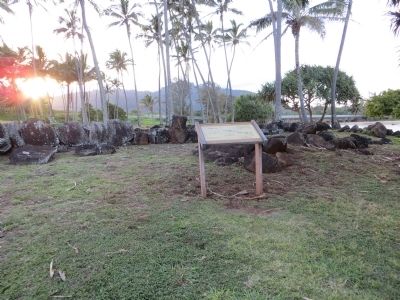
Many generations ago, every stone was brought by hand up to this bluff from the rivers below to build this heiau (temple). A heiau was often remodeled by a new ruling ali'i (chief) and his kahuna (priest).
Within . . . — — Map (db m65809) HM
Near Hawaii Route 580, 1.7 miles west of Hawaii Route 56, on the left when traveling west.
Steeped in Hawaiian oral traditions, Wai'ale'ale mountain represents the piko or navel of Kaua'i. Its peak, Kawaikini is the highest point on the island at 5,243 feet. Reputed as one of the world's wettest spots, it average 400 to 600 inches of . . . — — Map (db m65794) HM
On Hoonani Road east of Lawai Road, on the right when traveling east.
In the mid 1800s, Kōloa Landing was the third largest whaling port in all of Hawai‘i and the only port of entry for foreign goods. The sugar industry increased its use until 1912, when better facilities became available. Up to 60 ships a year . . . — — Map (db m12787) HM
Near Pe‘e Road south of Poipu Road, on the left when traveling south.
Stone and coral tools found a Keoneloa Bay , or long sand, helped arcaeologists determine that early Hawaiians used the area between 200 and 600 A.D. as a temporary fishing camp. Later Hawaiians left remnants of heiau, or temples, and ahu, or . . . — — Map (db m12806) HM
Near Pe‘e Road south of Poipu Road, on the left when traveling south.
The bay before you—named Keoneloa (or ‘the long sand’)—is the site of one of the oldest known Hawaiian occupation on Kaua‘i, a temporary fishing camp, dating to A.D. 220–660.
The Hawaiians divided each island into . . . — — Map (db m12807) HM
The landscape of Haleakalā National Park rises from a lush valley beneath a waterfall at sea level to a red desert of cinder cones here at the volcanic summit of Haleakala. An astounding array of climates and life zones lies in between. Yet the . . . — — Map (db m71753) HM