After filtering for North Dakota, 110 entries match your criteria. Entries 101 through 110 are listed.⊲ Previous 100
Industry & Commerce Topic
By Connor Olson, June 15, 2021
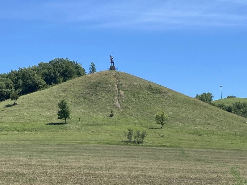
Pyramid Hill/Fort Ransom’s Remarkable Survival Marker
| 101 ► North Dakota, Ransom County, Fort Ransom — Pyramid Hill / Fort Ransom’s Remarkable Survival — |
| Pyramid Hill Pyramid Hill has long been a topic of local debate sometimes heated. The hill's obvious geometric shape begs the question of just how it was formed. Geologists believe that Pyramid Hill is a natural feature—the result of . . . — — Map (db m177165) HM | |||
| 102 ► North Dakota, Richland County, Abercrombie — Carpenter Shop — |
| In 1866 this building was listed on maps as Fort Abercrombie's carpenter shop. In 1868, Assistant Surgeon W. H. Gardner described this building as having rooms for a blacksmith, carpenter, painter and saddler. By 1871, maps show this being . . . — — Map (db m184217) HM | |||
| 103 ► North Dakota, Richland County, Abercrombie — Sutler / Post Trader — |
| The sutler's store was a log building situated on the southeast side of the fort. Sutlers were civilian contractors who supplied forts with items the army would not or could not supply. They sold food such as eggs, milk, cheese, and vegetables, . . . — — Map (db m176636) HM WM | |||
| 104 ► North Dakota, Stutsman County, Jamestown — Jamestown Dam — |
| Jamestown Dam 1953 Missouri River Basin project Built by and for the people of the United States for the conservation, control, and use of water resources. Height of Dam 110 Feet Length of Crest 1418 Feet Reservoir Capacity 230,000 Acre Feet . . . — — Map (db m90547) HM | |||
| 105 ► North Dakota, Traill County, Hillsboro — Nodak Rural Electric Cooperative, Inc. — |
| Nodak Rural Electric Cooperative, Inc., during North Dakota’s Centennial year, commemorates the pioneers of rural electrification and the community leaders who dared dream of a better way of life in the stark days of 1935 to 1940. As the State . . . — — Map (db m209452) HM | |||
| 106 ► North Dakota, Traill County, Mayville — Great Northern Railway Depot — |
| This property has been placed on the National Register of Historic Places by the United States Department of the Interior — — Map (db m242195) HM | |||
| 107 ► North Dakota, Ward County, Minot — Thanks to the United States Air Force — |
| This 1/8th scale model of The B52 Stratofortress Bomber is presented as a token of the greater Minot region’s support and sincere appreciation of The United States Air Force. We are specifically thankful for the men, women and their . . . — — Map (db m240862) WM | |||
| 108 ► North Dakota, Williams County, Williston — A Beaver Boom — Missouri-Yellowstone Confluence Interpretive Center — |
| beaver is in every bend -- William Clark Before the European colonization of North America, the use of animals for food and clothing seemed to have been in balance with the wildlife population. Once native people could trade pelts for . . . — — Map (db m143013) HM | |||
| 109 ► North Dakota, Williams County, Williston — Outpost on the Missouri — Fort Union Trading Post National Historic Site — National Park Service, U.S. Department of the Interior — |
| Early explorers reported that America’s western mountains were rich in furs. As a part of a plan to extend trading into the Upper Missouri country, John Jacob Astor’s American Fur Company built Fort Union here, near the junction of the Missouri and . . . — — Map (db m62068) HM | |||
| 110 ► North Dakota, Williams County, Williston — Post Trader's Complex — Fort Buford State Historic Site — |
| Post traders supplied forts with items the army would not or could not supply. Post traders could not sell any goods provided through the army's commissary. They sold food such as eggs, milk, cheese, vegetables, tobacco, and cloth. The post . . . — — Map (db m143067) HM | |||
110 entries matched your criteria. Entries 101 through 110 are listed above. ⊲ Previous 100