Grants in Cibola County, New Mexico — The American Mountains (Southwest)
El Malpais
National Conservation Area
— Bureau of Land Management —
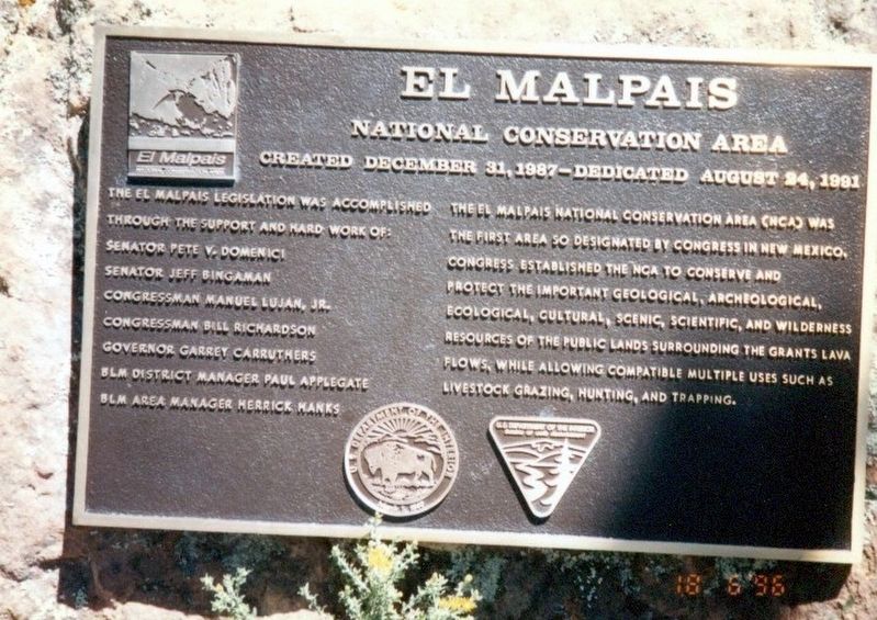
Created December 31, 1987-Dedicated August 24, 1991. The El Malpais National Conservation Area (NCA) was the first area so designated by Congress in New Mexico. Congress established the NCA to conserve and protect the important geological, archeological, ecological, cultural, scenic, scientific, and wilderness resources of the public lands surrounding the Grants Lava Flows, while allowing compatible multiple uses such as livestock grazing, hunting, and trapping.
The El Malpis legislation was accomplished through the support and hard work of: Senator Pete V. Domenici, Senator Jeff Bingaman, Congressman Manuel Lujan, Jr., Congressman Bill Richardson, Governor Garret Carruthers, BLM District Manager Paul Applegate, BLM Area Manager Herrick Hanks.
991.
Topics. This historical marker is listed in these topic lists: Anthropology & Archaeology • Environment • Natural Features • Science & Medicine. A significant historical date for this entry is August 24, 1991.
Location. Marker has been reported missing. It was located near 34° 58.236′ N, 107° 48.608′ W. Marker was in Grants, New Mexico, in Cibola County. Marker was on State Road 117. The marker is near the El Malpais Ranger
Other nearby markers. At least 8 other markers are within 13 miles of this location, measured as the crow flies. San Rafael (approx. 10.9 miles away); Grants (approx. 11.2 miles away); Old Acoma "Sky City" (approx. 11.6 miles away); The Fannie Mine Hoisting Bucket (approx. 12.9 miles away); One Ton Mine Car (approx. 12.9 miles away); Mine Head Frame (approx. 12.9 miles away); The Caboose (approx. 12.9 miles away); Large Diameter Drill Bit (approx. 12.9 miles away). Touch for a list and map of all markers in Grants.
Credits. This page was last revised on January 4, 2021. It was originally submitted on December 12, 2016, by Don Morfe of Baltimore, Maryland. This page has been viewed 631 times since then and 8 times this year. Photos: 1, 2, 3. submitted on December 12, 2016, by Don Morfe of Baltimore, Maryland. • Bill Pfingsten was the editor who published this page.


