The Palisades in Northwest Washington in Washington, District of Columbia — The American Northeast (Mid-Atlantic)
Carolina Park: Archaeology and History in the Palisades

Photographed By Devry Becker Jones (CC0), January 11, 2023
1. Carolina Park: Archaeology and History in the Palisades Marker
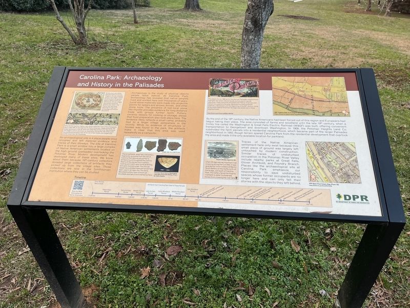
Archaeology is the study of physical objects people leave behind. At Carolina Park, archaeology has revealed that native peoples lived and worked here over thousands of years. Local stone materials were made into projectile points for spears and arrows, knives, and other stone tools. The presence of non-local stone like rhyolite provides evidence for long distance trade with groups farther north. Pottery, ceramic vessels for cooking or storage, shows that food preparation also took place here. The evidence likely reflects a small camp, probably tied to a larger village somewhere in the vicinity. While no evidence of structures or houses was found in the park, the artifacts make it clear that this area was used repeatedly as a campsite.
An archaeological site is a place people once occupied and left material evidence and traces of their lifeways. The site at Carolina Park is a small window into a large complex of native American settlements located on the high ground (palisades) overlooking the Potomac River. Modern development has destroyed many of these sites. We know about them because 19th-century collectors donated large collections of artifacts they picked up from the village sites. Those collections are now in the Smithsonian Institution where they can be studied.
By the end of the 18th century, the Native Americans had been forced out of this region and Europeans had begun taking their place. The area consisted of farms and woodland until the late 19th century, when a trolley line called the Washington & Great Falls Electric Railroad (W&GF) was built, offering convenient transportation to Georgetown and downtown Washington. In 1909, the Potomac Heights Land Co. subdivided the farm parcels into a residential neighborhood, which became part of the larger Palisades neighborhood in 1950. Rough terrain spared Carolina Park from the residential development that overtook the area and made it the only available location for parkland.
Traces of the Native American settlement here only exist because this small piece of ground was largely untouched by modern construction. Similar traces of undisturbed occupation in the Potomac River Valley include nearby parks at Great Falls, Glover Archbold, and Foundry Branch. Places like the archaeological site at Carolina Park emphasize our responsibility to save undisturbed spaces whose former occupants are no longer here and can only tell their stories with objects they left behind.
[Captions:]
British artist John White sketched Native American villages in the late sixteenth century. This village in North Carolina shows the general layout of Native American settlements. Similar villages were present along the

Photographed By Devry Becker Jones (CC0), January 11, 2023
2. Carolina Park: Archaeology and History in the Palisades Marker
When British explorer Captain John Smith sailed the rivers of the Chesapeake Bay in 1608-1609, he documented the Native American villages he found. The largest settlement in the DC area was called Nacotchtanck (or Nacotchtank). The villagers came to be known as Anacostins. During the 17th century the Nacotchtank/Anacostins were driven out of their homes and merged with another local tribe, the Piscataway.
The arrowheads, spear tips, and pottery fragments recovered from the site at Carolina Park (above) are similar to artifacts found throughout the District. Nearly all the pieces from a pottery cooking pot (right) were found at Bolling and were reconstructed. This circular vessel has a pointed base and would have been used in an open fire. This Early Woodland pottery type is known as Accokeek and has a cord-marked surface.
This detail of a ca. 1890 ad for the planned Palisades neighborhood highlights the area's natural beauty and access to natural resources. These resources attracted both Native American and historic occupants to the area. Because this area remained relatively undeveloped until the beginning of the 20th century, some of the area's Native American heritage was preserved in these neighborhoods.
Chain Bridge was an important river crossing during the Civil War. It was guarded by Union soldiers at Martin Scott Battery on the bluffs north of the bridge, just south of Carolina Park. The battery faced the Virginia riverbank to deter Confederate forces from crossing the river here.
Timeline
11,000 BC - 9,500 BC: Paleoindian Period
9,500 BC - 7,000 BC: Early Archaic Period
7,000 BC - 3,750 BC: Middle Archaic Period
Artifacts from Carolina Park Date to These Periods 3,750 BC - 1,250 BC: Late Archaic Period
1,250 BC - 50 AD: Early Woodland Period
50 AD - 950 AD: Middle Woodland Period
950 AD - 1600 AD: Late Woodland Period
1607: Jamestown Founded
1608: Capt. Smith Sails up Potomac
1634: St. Mary'c City Founded
1751: Georgetown Settled
1775-1783: American Revolution
1794: First Chain Bridge Built
1800 Federal Government moved to the District of Columbia
1861-1865: Civil War
1895: W&GF Trolley Opens
1909: Potomac Heights Subdivided
1950: Potomac Heights becomes Part of Palisades Neighborhood
2021: This Sign Created
Erected 2021 by DC Department of Parks and Recreation.
Topics. This historical marker is listed in these topic lists: Anthropology & Archaeology • Colonial Era • Exploration • Native Americans • Railroads & Streetcars • Settlements & Settlers • War, US Civil • Waterways & Vessels. A significant historical year for this entry is 1909.
Location. 38° 55.827′ N, 77° 6.594′ W. Marker is in Northwest Washington in Washington, District of Columbia. It is in The Palisades. Marker is on Macomb Street Northwest west of Carolina Place Northwest, on the right when traveling west. Touch for map. Marker is at or near this postal address: 5423 Macomb St NW, Washington DC 20016, United States of America. Touch for directions.
Other nearby markers. At least 8 other markers are within walking distance of this marker. A different marker also named Carolina Park: Archaeology and History in the Palisades (about 400 feet away, measured in a direct line); Chain Bridge (approx. 0.4 miles away in Virginia); The Mouth of Pimmit Run (approx. half a mile away in Virginia); Pimmit Run and Chain Bridge (approx. half a mile away in Virginia); Palisades Recreation Center (approx. half a mile away); World War II (approx. half a mile away); The General Lafayette sign on the side of the garden… (approx. half a mile away); As you are on the old Glen Echo Trolley line… (approx. half a mile away). Touch for a list and map of all markers in Northwest Washington.
Credits. This page was last revised on January 30, 2023. It was originally submitted on January 11, 2023, by Devry Becker Jones of Washington, District of Columbia. This page has been viewed 87 times since then and 29 times this year. Photos: 1, 2. submitted on January 11, 2023, by Devry Becker Jones of Washington, District of Columbia.