East Boston in Suffolk County, Massachusetts — The American Northeast (New England)
History of East Boston Immigration
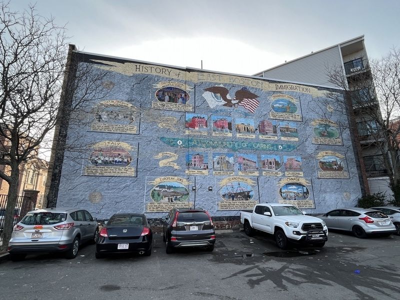
Latin America and the Caribbean
1900s - The second half of the 20th Century has seen a steady rise in population from all the countries of Central and South America, Mexico and the islands of the Caribbean.
Italy
1900s-2000s - The largest wave of immigrants in the early 20th Century came from Italy. In 1925, East Boston was 75 percent first or second generation Italian.
Southeast Asia and the World
1970's - Our Southeast Asian community has ground wince that war there. As we enter the 21st century, East Boston continues to be an attractive home for people from all over the world.
European Jews
1870's - 1910s - Fleeing persecution, Jews came from Russia and Germany. At the turn of the 20th Century, East Boston had the largest Jewish community in New England.
Scandinavia
1870s - 90s Also fleeing crop failures in Denmark, Sweden and Finland, many stayed as long as the maritime industries were here, but they were the first wave to mostly move inland.
Massachusetts Indians
Before 1620 - The five islands that now make up East Boston were used as hunting and fishing grounds.
1860s - The switch
this page online
England
1620 - 1834 - The colonists used the islands for common pasture and as a popular picnic area. The British army had a camp at Belmont Square before 1775.
Ireland
1840s-50s Fleeing famine, the Irish were the first great wave of immigrants to fill the newly laid-out neighborhood. They built Holy Redeemer Church in 1857. Meridian St. was the Kennedy family's first home in America.
A Community of Caring
History of Our Block
Trinity Settlement Homes
Jeffries Point Immigration Center
The Immigrants Home
Lyman School
The first branch library in America
St. John's Episcopal Church
First building on the site of this parking lot.
Paris St. Gymnasium
First Indoor Municipal Gymnasium in America.
Temple Ohel Jacob
Stood on the site of this parking lot from 1907 until destroyed by fire in 1973.
The White Building
Precursor to the East Boston Neighborhood Health Center
Erected 1998 by Chris Tauson, muralist.
Topics. This historical marker

Location. 42° 22.309′ N, 71° 2.309′ W. Marker is in Boston, Massachusetts, in Suffolk County. It is in East Boston. It is at the intersection of Paris Street and Gove Street, on the right when traveling south on Paris Street. Touch for map. Marker is at or near this postal address: 86 Paris St, East Boston MA 02128, United States of America. Touch for directions.

Regionally, this marker is in Historic Boston. It is also in the American Northeast, in New England, and on the Eastern Seaboard. Globally, it is in the North Atlantic Region, North America, the Western Hemisphere, the Western World, and the Anglosphere. Historically, it finds itself in what was once one of the original Thirteen Colonies.
Other nearby markers. At least 8 other markers are within walking distance of this marker: POW★MIA (about 400 feet away, measured in a direct line); Police Officer Ezekial W. Hodson (about 700 feet away); Veterans Memorial (approx. ¼ mile away); Commemorative Relief of Noddle's Island (approx. ¼ mile away); Islands - Volkan Alkanoglu, 2019 (approx. ¼ mile away); East Boston (approx. 0.3 miles away); Carlton's Wharf (approx. 0.3 miles away); a different marker also named East Boston (approx. 0.3 miles away). Touch for a list and map of all markers in Boston.
Credits. This page was last revised on February 5, 2023. It was originally submitted on February 5, 2023, by Devry Becker Jones of Washington, District of Columbia. This page has been viewed 929 times since then and 101 times this year. Photos: 1, 2. submitted on February 5, 2023, by Devry Becker Jones of Washington, District of Columbia.
