Fredericksburg, Virginia — The American South (Mid-Atlantic)
This natural rise in the landscape…

Photographed by Devry Becker Jones (CC0), March 4, 2023
1. This natural rise in the landscape… Marker
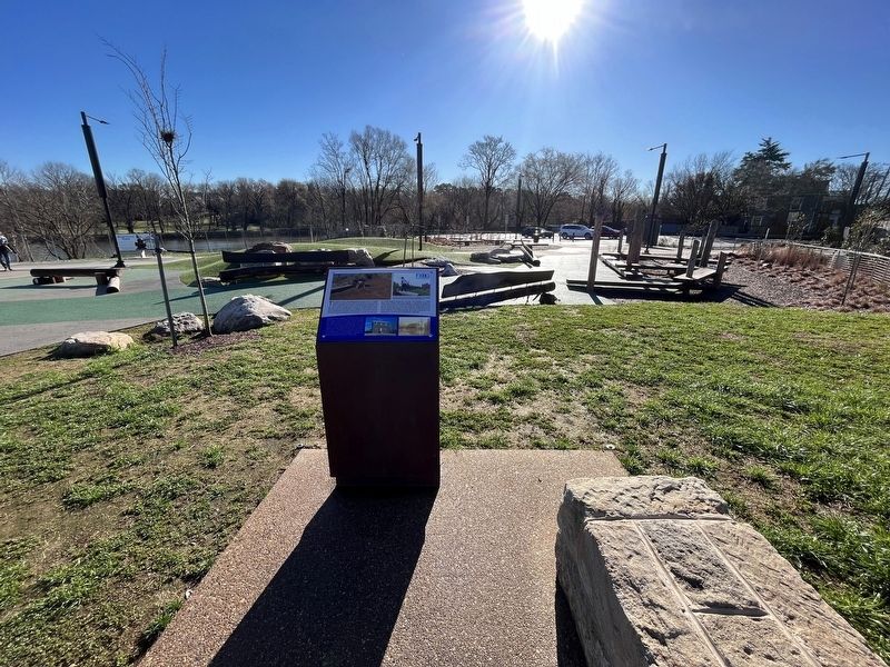
This natural rise in the landscape was once part of a larger earthen mound that was used for thousands of years, first by Native Americans and later by Fredericksburg residents. The site was a prime vantage point above the Rappahannock River and less prone to flooding due to its height. A trench likely used by both Confederate and Union troops during the Civil War cut across the mound and extended to the southwest. The site was also part of a field hospital during the Civil War. The remains of at least three Union soldiers were found nearby. A substantial expansion of the mound occurred in 1920, when fill was added to prepare the site for construction of a two-story residence. Designed by noted local architect and builder E.G. Peck Heflin, the home served as a rental residence, the Fredericksburg Day School, and, by 1972, the headquarters for the Prince Hall Masonic Lodge #61.
[Sidebar:]
Prince Hall Masonic Lodge #61, named for the father of Black Freemasonry in the United States, purchased the residence that sat atop this mound in 1972 (right). Though chartered in 1891, Lodge #61 did not own a building before this one. The picture at far right shows the building during a major flood in 1937. A series of changes were made under the Lodge's ownership, including removing the front porch and installing a brick veneer. The Lodge sold the property to the City of Fredericksburg in 2011. It was demolished in 2015 as the City Council and its Riverfront Task Force began to implement the decades-long vision of a downtown riverfront park.
[Caption:]
The dark line of a Civil War trench angles across the site,, now within the play area, during a 2017 archaeological study. Artifacts from the prehistoric period through the 20th century were identified during a series of studies. Image at left courtesy of Dovetail Cultural Resource Group.
Erected by City
this page online
Topics. This historical marker is listed in these topic lists: African Americans • Anthropology & Archaeology • Education • Fraternal or Sororal Organizations • Indigenous Peoples and Communities • Science & Medicine • War, US Civil. A significant historical year for this entry is 1920.
Location. 38° 18.067′ N, 77° 27.392′ W. Marker is in Fredericksburg, Virginia. It is at the intersection of Sophia Street and Charlotte Street, on the right when traveling north on Sophia Street. Touch for map. Marker is at or near this postal address: 609 Sophia St, Fredericksburg VA 22401, United States of America. Touch for directions.

Regionally, this marker is in the Washington Metropolitan Area and in Northern Virginia. It is also in the American South and specifically in the Upper South. Globally, it is in North America, the Western Hemisphere, the Western World, and the Anglosphere. Historically, it finds itself in what was once the territory of the Mississippian Culture, one of the original Thirteen Colonies, one of the Confederate States of America, and the Antebellum
Photographed by Devry Becker Jones (CC0), March 4, 2023
2. This natural rise in the landscape… Marker
Other nearby markers. At least 8 other markers are within walking distance of this marker: The sandstone blocks… (within shouting distance of this marker); 1846-47 / Philip Y. Wyatt (within shouting distance of this marker); Thornton's Tavern (about 300 feet away, measured in a direct line); Shiloh Baptist Church (Old Site) (about 400 feet away); The African Baptist Church (about 400 feet away); 1824 (about 400 feet away); Fréjus Place (about 400 feet away); c. 1816 (about 400 feet away). Touch for a list and map of all markers in Fredericksburg.
Other markers no longer nearby. Ferries and Flats (was within shouting distance of this marker but has been permanently removed); a different marker also named Shiloh Baptist Church (Old Site) (was about 400 feet away but has been replaced with another marker now near it); African Baptist Church of Fredericksburg (was about 400 feet away but has been replaced with another marker now near it).
Credits. This page was last revised on March 4, 2023. It was originally submitted on March 4, 2023, by Devry Becker Jones of Washington, District of Columbia. This page has been viewed 200 times since then and 19 times this year. Photos: 1, 2. submitted on March 4, 2023, by Devry Becker Jones of Washington, District of Columbia.
