Old Saybrook Center in Middlesex County, Connecticut — The American Northeast (New England)
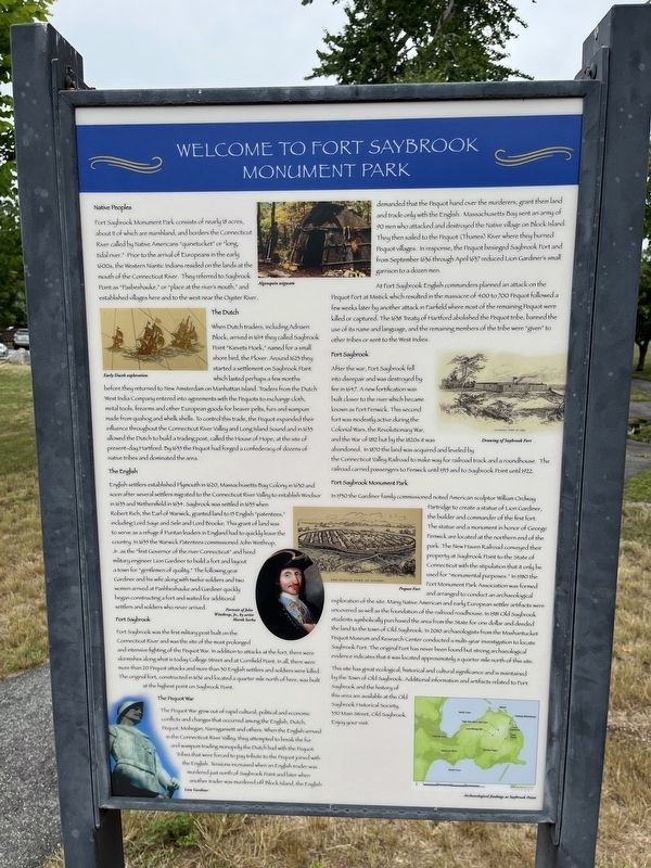
Welcome to Fort Saybrook Monument Park
Native Peoples
Fort Saybrook Monument Park consists of nearly 18 acres, about 11 of which are marshland, and borders the Connecticut River called by Native Americans "quineteckut" or "long, tidal river." Prior to the arrival of Europeans in the early 1600s, the Western Niantic Indians resided on the lands at the mouth of the Connecticut River. They referred to Saybrook Point as "Pasbeshauke," or "place at the river's mouth," and established villages here and to the west near the Oyster River.
The Dutch
When Dutch traders, including Adriaen Block, arrived in 1614 they called Saybrook Point "Kievets Hoek," named for a small shore bird, the Plover. Around 1623 they started a settlement on Saybrook Point which lasted perhaps a few months before they returned to New Amsterdam on Manhattan Island. Traders from the Dutch West India Company entered into agreements with the Pequots to exchange cloth, metal tools, firearms and other European goods for beaver pelts, furs and wampum made from quahog and whelk shells. To control this trade, the Pequot expanded their influence throughout the Connecticut River Valley and Long Island Sound and in 1633 allowed the Dutch to build a trading post, called the House of Hope, at the site of present-day Hartford. By 1635 the Pequot had forged a confederacy of dozens of native tribes and dominated the area.
The English
English settelrs established Plymouth in 1620, Massachusetts Bay Colony in 1630 and soon after several settelrs migrated to the Connecticut River Valley to establish Windsor in 1633 and Whethersfield in 1634. Saybrook was settled in 1635 when Robert Rich, the Earl of Warwick, granted land to 15 English "patentees," including Lord Saye and Sele and Lord Brooke. This grant of land was to serve as a refuge if Puritan leaders in England had to quickly leave the country. In 1635 the Warwick Patentees commissioned John Winthrop, Jr. as the "first Governor of the river Connecticut" and hired military engineer Lion Gardiner to build a fort and layout a town for "gentlemen of quality." The following year Gardiner and his wife along with twelve soldiers and two women arrived at Pashbeshauke and Gardiner quickly began constructing a fort and waited for additional settlers and soldiers who never arrived.
Fort Saybrook
Fort Saybrook was the first military post built on the Connecticut River and was the site of the most prolonged and intensive fighting of the Pequot War. In addition to attacks at the fort, there were skirmishes along what is today College Street and at Cornfield Point. In all, there were more than 20 Pequot attacks and more than 30 English settlers and soldiers killed. The original
fort, constructed in 1636 and located a quarter mile north of here, was built at the highest point on Saybrook Point.
The Pequot War
The Pequot War grew out of rapid cultural, political and economic conflicts and changes that occurred among the English, Dutch, Pequot, Mohegan, Narragansett and others. When the English arrived in the Connecticut River Valley, they attempted to break the fur and wampum trading monopoly the Dutch had with the Pequot. Tribes that were forced to pay tribute to the Pequot joined with the English. Tensions increased when an English trader was murdered just north of Saybrook Point and later when another trader was murdered off Block Island, the English demanded that the Pequot hand over the murderers, grant them land and only trade with the English. Massachusetts Bay sent an army of 90 men who attacked and destroyed the Native village on Block Island. They then sailed to the Pequot (Thames) River where they burned Pequot villages. In response, the Pequot besieged Saybrook Fort and from September 1636 through April 1637 reduced Lion Gardiner's small garrison to a dozen men.
At Fort Saybrook English commanders planned an attack on the Pequot Fort at Mistick which resulted in the massacre of 400 to 700 Pequot followed a few weeks later by another attack in Fairfield where most of the remaining Pequot were killed or captured. The 1638 Treaty of Hartford abolished the Pequot tribe, banned the use of its name and language, and the remaining members of the tribe were "given" to other tribes or sent to the West Indies.
Fort Saybrook
After the war, Fort Saybrook fell into disrepair and was destroyed by fire in 1647. A new fortification was built closer to the river which became known as Fort Fenwick. This second fort was modestly active during the Colonial Wars, the Revolutionary War, and the War of 1812 but by the 1820s it was abandoned. In 1870 the land was acquired and leveled by the Connecticut Valley Railroad to make way for railroad track and a roundhouse. The railroad carried passengers to Fenwick until 1915 and to Saybrook Point until 1922.
Fort Saybrook Monument Park
In 1930 the Gardiner family commissioned noted American sculptor William Ordway Partridge to create a statue of Lion Gardiner, the builder and commander of the first fort. The statue and a monument in honor of George Fenwick are located at the northern end of the park. The New Haven Railroad conveyed their property at Saybrook Point to the State of Connecticut with the stipulation that it only be used for "monumental purposes." In 1980 the Fort Monument Park Association was formed and arranged to conduct an archaeological exploration of the site. Many Native American and early European settler artifacts were uncovered as well as the foundation of the railroad roadhouse. In 1981 Old Saybrook students symbolically purchased the area from the State for one dollar and deeded the land to the town of Old Saybrook. In 2010 archaeologists from the Mashantucket Pequot Museum and Research Center conducted a multi-year investigation to locate Saybrook Fort. The original Fort has never been found but strong archaeological evidence indicates that it was located approximately a quarter mile north of this site.
This site has great ecological, historical and cultural significance and is maintained by the Town of Old Saybrook. Additional information and artifacts related to Fort Saybrook and the history of this area are available at the Old Saybrook Historical Society, 350 Main Street, Old Saybrook. Enjoy your visit.
Topics. This historical marker is listed in these topic lists: Anthropology & Archaeology • Colonial Era • Forts and Castles • Native Americans • Parks & Recreational Areas • Settlements & Settlers • Wars, US Indian. A significant historical month for this entry is April 1637.
Location. 41° 17.069′ N, 72° 21.054′ W. Marker is in Old Saybrook, Connecticut, in Middlesex County. It is in Old Saybrook Center. Marker is on College Street east of Bridge Street (Connecticut Route 154) when traveling west. Touch for map. Marker is at or near this postal address: 160 College Street, Old Saybrook CT 06475, United States of America. Touch for directions.
Other nearby markers. At least 8 other markers are within walking distance of this marker. The Ferry (here, next to this marker); Lighthouses and River Pilots (here, next to this marker); Connecticut Valley Railroad Roundhouse & Turntable Site (within shouting distance of this marker); The Connecticut Valley Railroad (within shouting distance of this marker); Welcome to Fort Saybrook (within shouting distance of this marker); The Saybrook Bar (within shouting distance of this marker); Fishing on the Connecticut (within shouting distance of this marker); Adriaen Block & New Netherland (within shouting distance of this marker). Touch for a list and map of all markers in Old Saybrook.
Related marker. Click here for another marker that is related to this marker. This marker has replaced the linked marker.
Credits. This page was last revised on July 1, 2023. It was originally submitted on July 1, 2023, by Devry Becker Jones of Washington, District of Columbia. This page has been viewed 124 times since then and 35 times this year. Photos: 1, 2, 3. submitted on July 1, 2023, by Devry Becker Jones of Washington, District of Columbia.


