Cartersville in Bartow County, Georgia — The American South (South Atlantic)
The Defensive Ditch/Borrow Pit
| — | Etowah Indian Mounds State Historic Site | — |
Photographed by Brandon D Cross
1. The Defensive Ditch/Borrow Pit Marker
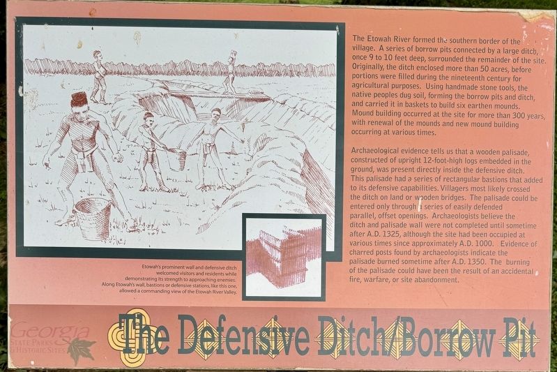
Archaeological evidence tells us that a wooden palisade, constructed of upright 12-foot-high logs embedded in the ground, was present directly inside the defensive ditch. This palisade had a series of rectangular bastions that added to its defensive capabilities. Villagers most likely crossed the ditch on land or wooden bridges. The palisade could be entered only through a series of easily defended parallel, offset openings. Archaeologists believe the ditch and palisade wall were not completed until sometime after A.D. 1325, although
this page online
(caption) Etowah's prominent wall and defensive ditch welcomed visitors and residents while demonstrating its strength to approaching enemies. Along Etowah's wall, bastions or defensive stations, like this one, allowed a commanding view of the Etowah River Valley.
Erected by Georgia Council on American Indian Concerns.
Topics. This historical marker is listed in these topic lists: Anthropology & Archaeology • Cemeteries & Burial Sites • Forts and Castles • Indigenous Peoples and Communities • Parks & Recreational Areas. A significant historical year for this entry is 1325.
Location. 34° 7.663′ N, 84° 48.439′ W. Marker is in Cartersville, Georgia, in Bartow County. It can be reached from Indian Mounds Road SE 0.2 miles south of Sequoyah Circle, on the left when traveling south. Located on the grounds of Etowah Indian Mounds State

Photographed by Brandon D Cross
2. The Defensive Ditch/Borrow Pit Marker

Regionally, this marker is in Georgia’s Mountains. It is also in the American South and specifically in the Deep South. Globally, it is in North America, the Western Hemisphere, the Western World, and the Anglosphere. Historically, it finds itself in what was once the original Cherokee Nation, the territory of the Mississippian Culture, one of the original Thirteen Colonies, one of the Confederate States of America, and the Antebellum South.
Other nearby markers. At least 8 other markers are within walking distance of this marker: Etowah’s Wattle and Daub House (a few steps from this marker); Remote Sensing at Etowah (within shouting distance of this marker); A Return to Native Grasses (within shouting distance of this marker); Etowah Mounds (within shouting distance of this marker); A Chiefly Village on the Etowah (about 400 feet away, measured in a direct line); Etowah (Tumlin) Mounds (about 700 feet away); Mound A - Symbol of a Chiefdom (approx. 0.2 miles away); Etowah’s Past, Present, and Future (approx. 0.2 miles away). Touch for a list and map of all markers in Cartersville.
Also see . . . Etowah Indian Mounds State Historic Site. (Submitted on July 1, 2024, by Brandon D Cross of Flagler Beach, Florida.)
Credits. This page was last revised on July 1, 2024. It was originally submitted on July 1, 2024, by Brandon D Cross of Flagler Beach, Florida. This page has been viewed 300 times since then and 46 times this year. Photos: 1, 2. submitted on July 1, 2024, by Brandon D Cross of Flagler Beach, Florida. • Bernard Fisher was the editor who published this page.
