Ceylon in Erie County, Ohio — The American Midwest (Great Lakes)
History of Old Woman Creek
| — | Old Woman Creek National Estuarine Research Reserve | — |
Photographed by Craig Doda, June 6, 2026
1. History of Old Woman Creek Marker
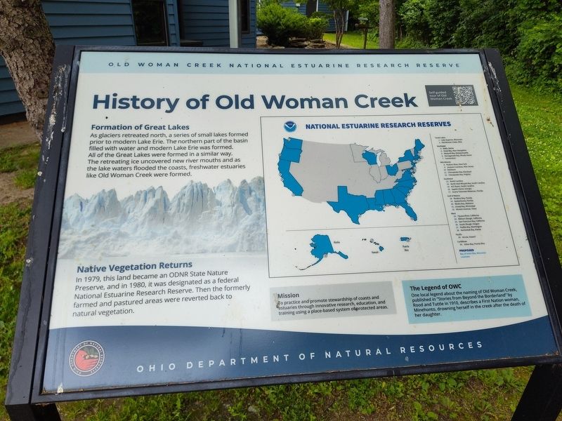
Formation of Great Lakes
As glaciers retreated north, a series of small lakes formed prior to modern Lake Erie. The northern part of the basin filled with water and modern Lake Erie was formed. All of the Great Lakes were formed in a similar way. The retreating ice uncovered new river mouths and as the lake waters flooded the coasts, freshwater estuaries like Old Woman Creek were formed.
Native Vegetation Returns
In 1979, this land became an ODNR State Nature Preserve, and in 1980, it was designated as a federal National Estuarine Research Reserve. Then the formerly farmed and pastured areas were reverted back to natural vegetation.
Mission
To practice and promote stewardship of coasts and estuaries through innovative research, education, and training using a place-based system of protected areas.
The Legend of OWC
One local legend about the naming of Old Woman Creek, published in "Stories from Beyond the Borderland" by Rood and Tuttle in 1910, describes a First Nation woman, Minehonto, drowning herself in the creek after the death of her daughter.
Erected by Ohio Department of Natural Resources.
Topics.
this page online
Location. 41° 22.666′ N, 82° 30.53′ W. Marker is in Ceylon, Ohio, in Erie County. It is at the intersection of Cleveland Road East (U.S. 6) and Mirheath Drive, on the right when traveling east on Cleveland Road East. Touch for map. Marker is at or near this postal address: 2514 Cleveland Rd E, Huron OH 44839, United States of America. Touch for directions.

Regionally, this marker is on the Lake Erie Shore and in the Western Reserve. It is also in the American Midwest and in the Corn Belt. Globally, it is in North America, on the Great Lakes, in the Western Hemisphere, in the Western World, and in the Anglosphere. Historically, it finds itself in what was once the Haudenosaunee (Iroquois) Confederacy, the territory of the Mississippian Culture, and the Northwest Territory.
Other nearby markers. At least 8 other markers are within 3 miles of this marker, measured as the crow flies: The Value of Wetlands (about 400 feet away,
Photographed by Craig Doda, June 6, 2026
2. History of Old Woman Creek Marker
Credits. This page was last revised on June 10, 2026. It was originally submitted on June 9, 2026, by Craig Doda of Napoleon, Ohio. This page has been viewed 14 times since then. Photos: 1, 2. submitted on June 9, 2026, by Craig Doda of Napoleon, Ohio. • Devry Becker Jones was the editor who published this page.
