Macon in Bibb County, Georgia — The American South (South Atlantic)
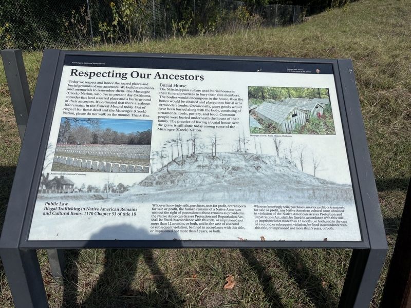
Respecting Our Ancestors
| — | Ocmulgee National Monument | — |
Photographed by Benjamin Rubin, October 25, 2026
1. Respecting Our Ancestors Marker
Burial House
The Mississippian culture used burial houses in their funeral practices to bury their elite members. The bodies would decompose in the house, then the bones would be cleaned and placed into burial urns or wooden tombs. Occasionally, grave goods would have been buried along with the body, consisting of ornaments, tools, pottery, and food. Common people were buried underneath the house of their family. The practice of having a burial house over the grave is still done today among some of the Muscogee (Creek) Nation.
Public Law
Illegal Trafficking in Native American Remains and Cultural Items. 1170 Chapter 53 of title 18
Whoever knowingly sells, purchases,
this page online
Whoever knowingly sells, purchases, uses for profit, or transports for sale or profit, any Native American cultural items obtained in violation of the Native American Graves Protection and Repatriation Act, shall be fined in accordance with this title, or imprisoned not more than 12 months, or both, and in the case of a second or subsequent violation, be fined in accordance with this title, or imprisoned not more than 5 years, or both.
(captions)
Andersonville National Cemetery
Muscogee (Creek) Burial Houses, Oklahoma
Erected by National Park Service, U.S. Department of the Interior.
Topics. This historical marker is listed in these topic lists: Anthropology & Archaeology • Cemeteries & Burial Sites • Indigenous Peoples and Communities • Parks & Recreational Areas.
Location. 32° 50.378′ N, 83° 36.678′ W. Marker is in Macon, Georgia, in Bibb County. It can be reached from Ocmulgee National Park Road south of Emery Highway (U.S. 23), on the right when traveling south. Touch for map. Marker is at or near this postal address: 1207 Emery Hwy, Macon GA 31217, United States of America. Touch for directions.

Regionally, this marker is in the Piedmont. It is also in the American South and specifically in the Deep South. Globally, it is in North America, the Western Hemisphere, the Western World, and the Anglosphere. Historically, it finds itself in what was once the territory of the Mississippian Culture, one of the original Thirteen Colonies, one of the Confederate States of America, and the Antebellum South.
Other nearby markers. At least 8 other markers are within walking distance of this marker: Funeral Mound of the Mississippians (here, next to this marker); Mississippian Diet (about 300 feet away, measured in a direct line); Lesser Temple Mound (approx. 0.2 miles away); Muscogee (Creek) 1600-1826 (approx. ¼ mile away); Trading with the British 1690-1715 (approx. ¼ mile away); Paleo Indian Period 15000 B.C.E. - 8000 B.C.E. (approx. ¼ mile away); Mississippian Period 900 - 1600 (approx. ¼ mile away); The Great Temple Mound and Town Site (approx. ¼ mile away). Touch for a list and map of all markers in Macon.
Also see . . . Ocmulgee Mounds National Historical Park. National Park Service (Submitted on November 11, 2026.)
Credits. This page was last revised on November 11, 2026. It was originally submitted on November 10, 2026, by Benjamin Rubin of Columbia, South Carolina. This page has been viewed 8 times since then. Photo 1. submitted on November 10, 2026, by Benjamin Rubin of Columbia, South Carolina. • Bernard Fisher was the editor who published this page.
