On Main Street (New Brunswick Route 114) at Hopewell Cross Road, on the left when traveling north on Main Street.
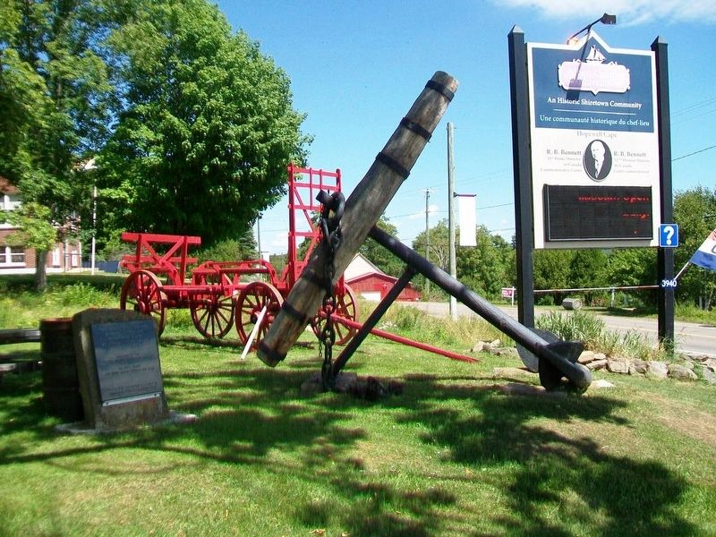
This 18th century anchor
retrieved from the
Petitcodiac River
at Hopewell Cape in 1981
by Jack Weldon
Donated to the
Albert County Historical Society
by
his wife Grace
and sons James, Thomas and Dale
This plaque was given as a . . . — — Map (db m106638) HM
On Main Street (Route 103) north of Maple Street, on the left when traveling north.
(English:) Captured World War I German 77mm field gun manufactured by Krupp Armaments in Germany and introduced in 1896. Model: C96n/A Calibre: 77mm Maximum Range: 9186 yards (5 Miles) Weight: 1930 lbs. (8 75kg) Rate of Fire: 10 . . . — — Map (db m138994) HM WM
On rue Canada (New Brunswick Route 17) just south of rue Deschênes, on the left when traveling south.
La croix et le coq sont au sommet de la plus haute structure de la Ville de Saint-Quentin. Le coq et la croix du clocher de l'église du Très Saint-Sacrement proviennent de l'église précédente détruite par le feu au soir du 10 . . . — — Map (db m125680) HM
On rue Canada (New Brunswick Route 17) just south of rue Deschênes, on the left when traveling south.
La fontaine fut érigée en 1957 en l'honneur des fondateurs de Saint-Quentin, elle est un don de M. Patrick Jean, entrepreneur prolifique de la paroisse. Elle fut construite par. M. Andréas Coulombe.
Le dévoilement du monument . . . — — Map (db m125684) HM
On Prince William Street at Princess Street, on the left when traveling north on Prince William Street.
English: This historic streetscape is distinguished by its rare concentration of homogeneous, primarily late 19th century architecture. Traditionally referred to as “Wall Street,” the area contains major public buildings, banks, . . . — — Map (db m137519) HM
Near Lancaster Avenue, 0.2 kilometers east of Bridge Road (New Brunswick Route 100), on the left when traveling east.
English:
In 1822 when Robert Foulis arrived in Saint John, New Brunswick he was 30 years old, a well-educated Scotsman from Glasgow, recognized as brilliant in sciences, and trained as an engineer. He spent the rest of his life in . . . — — Map (db m141998) HM
On Broadway Boulevard (New Brunswick Route 130) at Court Street, in the median on Broadway Boulevard.
In honored memory of
the men of
Grand Falls who
laid down their lives
in the Great War
1914 ——— 1918
Their names
liveth forever
[Honored Dead]
Paul E. Green • John A. Taylor • T. H. Pirie • R. A. Estey
Reed West . . . — — Map (db m125314) WM
On Main Street (New Brunswick Route 940) just south of Fawcett Avenue, on the right when traveling south.
A pump-house was constructed on this site in the fall of 1919 to house a large water pump driven by a 40HP electric motor. The pump was installed to boost the water pressure in the Town’s hydrants during times when water was required for fire . . . — — Map (db m106382) HM
On Main Street (New Brunswick Route 940) at Rectory Lane, on the right when traveling north on Main Street.
The rectory was constructed in the Queen Anne Revival style in 1880 on land given by J.F. Allison and Mary Allison Botsford. The design was prepared by R. C. Boxall and constructed by Mr. J. Teed of Dorchester. Great pains were taken with the . . . — — Map (db m106390) HM
On Main Street (New Brunswick Route 106) at Allison Avenue, on the right when traveling south on Main Street.
Erected by
the Town of Sackville
to commemorate
the designer
of the Canadian flag
George F. G. Stanley
C.C., C.D., K.StJ., D.Phil., LL.D.
Former Lieutenant-Governor of
New Brunswick, Professor, Historian,
Second World War . . . — — Map (db m106430) HM
On Main Street (New Brunswick Route 940), on the right when traveling north.
The construction of St. Paul's began in 1856, based on a model brought by the Rt. Rev. John Medley, First Bishop of Fredericton. Bishop Medley's interest in Gothic Revival architecture, recreating a medieval stone building in New Brunswick wood, . . . — — Map (db m106421) HM
On Bridge Street (New Brunswick Route 106) at Weldon Street, on the left when traveling east on Bridge Street.
The Royal Canadian Air Force has stood on guard for Canada since 1924. Over three hundred and twenty five Sackville area residents and students of Mount Allison University have served in the R.C.A.F. both here and abroad from the First World War . . . — — Map (db m106550) HM
On Rue Carleton Street north of Queen Street (New Brunswick Route 102), on the left when traveling north.
English:
This building is one of four remaining structures of the British establishment which housed the garrison at Fredericton from 1784 until the withdrawal of Imperial troops in 1869. Occupying the area between York and Regent . . . — — Map (db m139996) HM