For almost 60 years, from 1821 to 1880, the Santa Fe Trail was part of a complex web of international trade and business. The trail began as a connection from the Missouri frontier in the United States to Santa Fe in Mexico. Spanning 900 miles, the . . . — — Map (db m184611) HM
The Old Spanish Trail from Santa Fe to Los Angeles. In the years 1829 to 1848 pack mule trains regularly left the Santa Fe Plaza and northern New Mexico carrying woolen goods produced in New Mexico bound for California. Horses and mules were . . . — — Map (db m64852) HM
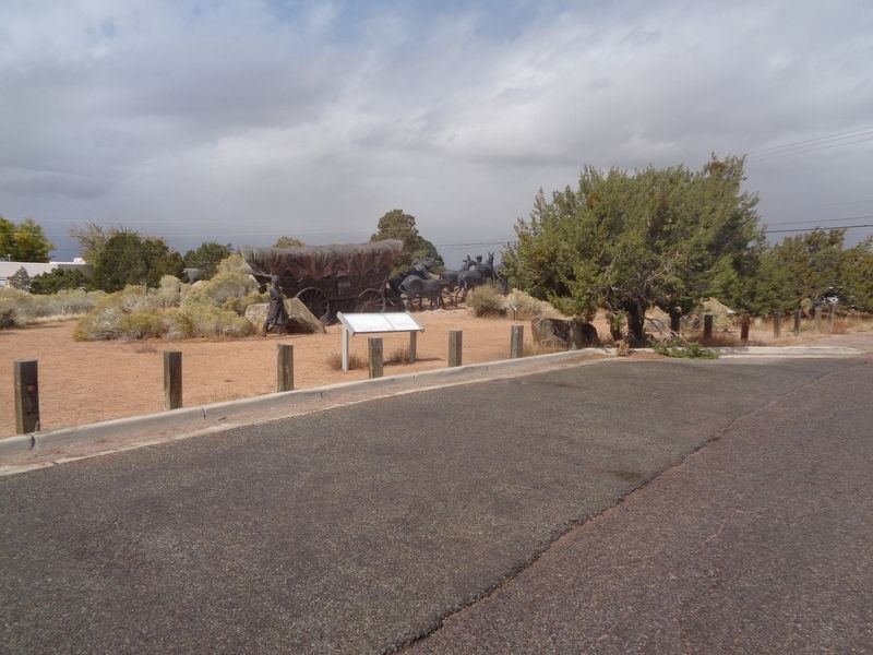
Near to where you are standing is the route of one of the great overland trails of one of the great overland trails of the old west. Established in 1821, as a trade route between Franklin, Missouri, in the United States, and Santa Fe, then part of . . . — — Map (db m185096) HM
Santa Fe became a hub of international trade in the 1800s. Materials from European and US manufacturers arrived from the east. Goods from central Mexico and South America arrived from the south. Products were traded at western ports for livestock . . . — — Map (db m184605) HM
You are standing on Fort Marcy Hill, a site of human occupation for a thousand years. Pueblo Indians and their ancestors lived here. Between 1600 and 1680, the hill was common land for Santa Fe colonists. The Spanish built a small fort on a hill . . . — — Map (db m184791) HM
This section of the Camino Real is called the Jornada del Muerto or Deadman’s Journey after the tragic fate of German trader Bernardo Gruber, El Alemán. In 1670 the Inquisition accused him of witchcraft. He escaped and attempted to cross ninety . . . — — Map (db m187520) HM
Cutting through the southern edge of the Manzano
Mountains, this area has always been an important
trade route. The trail linked Abó and the Salinas
pueblos to the Rio Grande pueblos, fostering trade of
beans, cotton, buffalo meat and salt with . . . — — Map (db m235442) HM
In 1582 and 1583, Antonio de Espejo and his party followed the Rio Grande north to the Bernalillo area. Espejo was trying to learn the fate of two Franciscan friars who stayed with the Pueblo Indians after the Rodriquez – Sanchez/Chamuscado . . . — — Map (db m68057) HM
South across the road lies one of the west's historic "hoof highways" which was used annually from 1885 until 1971. Sheep and cattle were driven to and from the railroad at Magdalena, NM or to Springerville, AZ. The driveway was 5 to 10 miles wide . . . — — Map (db m60565) HM
The mountain range seen along the east bank of the Rio Grande is named after Father Cristobal de Salazar of the 1598 Juan de Oñate expedition. The northern edge of the twenty-one mile range is said to resemble the profile of the good friar. This . . . — — Map (db m45132) HM
Front of Marker
In 1598 the first Spanish settlers in New Mexico traveled up the Camino Real from north-central Mexico. Of the 560 people so far identified on that expedition, at least 20 percent were women. They came on foot, on wagons or . . . — — Map (db m45131) HM
This road passes through some of the most spectacular scenery in the American Southwest. It is a key section of the east - west highway which brings visitors to this region from throughout the United States. Since this route became a reality . . . — — Map (db m58967) HM
Kit Carson Road, originally
called El Camino de Cañon de
Taos or Taos Canyon Road, was
the home of Kit Carson. Through
its long history, this road has
been a street of residences,
businesses, artists' studios and
galleries. — — Map (db m236603) HM
Trade caravans and homesteaders traveling the Cimarron Cutoff of the Santa Fe Trail passed near here. Clayton was founded in 1887 and named for the son of cattleman and ex-Senator Stephen W. Dorsey, one of its developers. It became a major livestock . . . — — Map (db m55218) HM
These two striking mounds were the first features to become visible to Santa Fe Trail traffic crossing into New Mexico from Oklahoma, and so became important landmarks for caravans.
From here, traffic on this major 19th century commercial route . . . — — Map (db m55217) HM
These two striking mounds were the first features to become visible to Santa Fe Trail traffic crossing into New Mexico from Oklahoma, and so became important landmarks for caravans.
From here, traffic on this major 19th century commercial route . . . — — Map (db m55219) HM
William Becknell, the first Santa Fe Trail trader, entered Santa Fe in 1821 after Mexico became independent from Spain and opened its frontier to foreign traders. The Mountain Branch over Raton Pass divided here. One fork turned to Cimarron, . . . — — Map (db m55235) HM
Santa Fe Trail Cimarron Cutoff
The Santa Fe Trail was the major trade route between New Mexico and Missouri from 1821 until arrival of the railroad in 1880. The Cimarron Cutoff, a major branch of the Trail, passed through this portion of . . . — — Map (db m55236) HM
Near where you are standing was
one of the great overland trade
routes of the 19th century.
Connecting Franklin, Missouri,
with Santa Fe, New Mexico, the
trail ran 900 miles through rough
terrain hostile to all but the hardiest
traders set . . . — — Map (db m162262) HM
Stretching 900 miles from Franklin, Missouri to Santa Fe, New Mexico, the Santa Fe Trail was one of the most important North American trade routes of the nineteenth century. Begun in 1821, it was in use for 60 years until the arrival of the . . . — — Map (db m88753) HM
Camino Del Llano (Road to the Plains) played a significant role in the history of Belen and the surrounding communities. While the history of its use extends into colonial New Mexico, it continued to be defined by trade and commerce into the 20th . . . — — Map (db m169529) HM
122 entries matched your criteria. Entries 101 through 122 are listed above. ⊲ Previous 100