Near Mount Independence Road, on the right when traveling north.
Fortification was begun in June of 1776, and the name Mount Independence was bestowed following the Declaration of Independence. Lieut. Col. Jeduthan Baldwin was the chief construction engineer. Here the exhausted American Army, Northern Department, . . . — — Map (db m9275) HM
Near Mount Independence Road, on the right when traveling south.
“ . . . the possession of every thing here depends upon keeping the Command of the Water.” - Maj. Gen. Horatio Gates, July 16, 1776 In front of you is Lake Champlain, at 120 miles long the sixth largest lake in the United . . . — — Map (db m19440) HM
Near Mount Independence Road, on the right when traveling south.
“ . . . this Day there was two men Buried from our Regt.” - Lt. Jonathan Burton, October 4, 1776 This small stone, engraved “N. Richardson of Staddard Eng died 1760,” may mark the only identified grave on . . . — — Map (db m17849) HM
Near Mount Independence Road, on the right when traveling south.
“The Generals have Fix’d on a spot . . . to be fortified.” - Lt. Col. Matthias Ogden, July 19, 1776 On July 5, 1777, Thomas Anburey, who was traveling with British Lt. Gen. John Burgoyne on Lake Champlain, observed as they . . . — — Map (db m19480) HM
Near Mount Independence Road, on the right when traveling south.
“ . . . some of the officers have good framed houses.” - Dr. Lewis Beebe, September 30, 1776 This fifteen-foot square, well-defined stone foundation may be the remains of quarters for one or more American officers in the . . . — — Map (db m17863) HM
Near Mount Independence Road, on the right when traveling south.
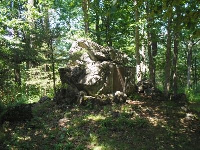
“ . . . a perfect mousetrap.” - Col. Alexander Scammell, September 21, 1777 From here are seen nearly all the powerful forces of nature that made this spot on Lake Champlain the Gibraltar of the North as well as its . . . — — Map (db m17846) HM
Near Mount Independence Road, on the right when traveling south.
“ . . . the new Hospital . . . 250 long & 24 wide.” - Rev. Enos Hitchcock, June 14, 1777 This shallow, dry-laid stone foundation was for the largest building at Mount Independence – a 250-foot long by 24-foot wide, . . . — — Map (db m19319) HM
Near Mount Independence Road, on the right when traveling south.
“Some of the intrenchments are still visible.” – John Disturnell, 1857 After the American Revolution, numerous visitors curious to see the places that figured so prominently in the war for independence visited Mount . . . — — Map (db m19501) HM
Near Mount Independence Road, on the right when traveling south.
“I have also provided timber for two Blockhouses.” - Col. Anthony Wayne, February 4, 1777 In the summer and fall of 1776 American forces concentrated on fortifying the northern point of the rocky Mount Independence . . . — — Map (db m19321) HM
Near Mount Independence Road, on the right when traveling south.
“ordered a large Stoer House to be built.” - Col. Jeduthan Baldwin, August 17, 1776 At least one of the storehouses constructed on Mount Independence during the Revolution stood in this area. Portions of the remaining . . . — — Map (db m19366) HM
Near Mount Independence Road, on the right when traveling south.
“Blockhouses, none of them finished.” - Lt. John Starke, Royal Navy, September 1777 After the British captured Mount Independence on July 6, 1777, their military engineers decided to build six new blockhouses to augment . . . — — Map (db m19332) HM
Near Mount Independence Road, on the right when traveling south.
“we are Building a Large & Long Breast work on the South Side.” - Pvt. Thomas Killam, August 19, 1776 When the American Northern Army arrived at Ticonderoga in mid-July 1776, the 300-acre peninsula opposite on the Vermont . . . — — Map (db m19543) HM
Near Mount Independence Road, on the right when traveling south.
“began the works at 3 places on Mount Independence.” - Col. Jeduthan Baldwin, June 20, 1777 On June, 1777, American Chief Engineer Jeduthan Baldwin wrote in his journal, “in the afternoon went with Col. Kosiusko . . . — — Map (db m19437) HM
Near Mount Independence Road, on the right when traveling south.
This is one of the best-preserved stone foundations on Mount Independence. It was built during the Revolution, but historic maps and documents do not refer to it. Who built it? Did the Americans have time to build it during the two weeks in June . . . — — Map (db m19441) HM
Near Mount Independence Road, on the right when traveling south.
“Our men built huts out of boards to protect themselves from the cold weather.” - Lt. Von Hille, October 22, 1777 During the American occupation from July 1776 to July 1777, soldiers constructed a breastwork of logs and . . . — — Map (db m19436) HM
On Mount Independence Road, on the left when traveling south.
This walkway is a loop approximately 0.2 mile long with stairs and gentle slopes. It leads you past the remains of a blockhouse (near the parking area), provides a look at the Mount’s rock formations, and provides a vista of the lake south of the . . . — — Map (db m19536) HM