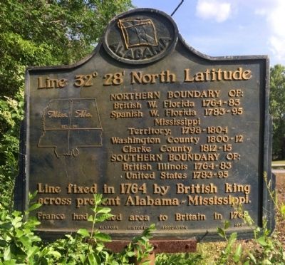
On County Road 430 0.6 miles south of County Road 248, on the left when traveling south.
Northern Boundary of:
British W. Florida 1764-83
Spanish W. Florida 1783-95
Mississippi Territory: 1798-1804
Washington County 1800-12
Clarke County 1812-15
Southern Boundary of:
British Illinois 1764-83
United States . . . — — Map (db m73532) HM
On 4th Avenue (U.S. 11) 0.6 miles north of Longshore Drive, on the right when traveling north.
Northern Boundary of:
British W. Florida 1764-83
Spanish W. Florida 1783-95
Mississippi Territory: 1798-1804
Washington County 1800-12
Clarke County 1812-15
Southern Boundary of:
British Illinois 1764-83
United States . . . — — Map (db m89725) HM
On Alabama Route 69 at Hodge Road, on the right when traveling north on Alabama Route 69.
This marker stands inside the Mitchell Reserve, created Nov. 16, 1805 by the Treaty of Mount Dexter between the Choctaw Nation & the United States. The Reserve begins at a "post on the left bank of the Tombigbee River opposite the lower end of . . . — — Map (db m244880) HM
On U.S. 84 at milepost 40 at Crescent Road, on the right when traveling east on U.S. 84.
Side 1
Near this spot are the graves of American Revolution soldier Elijah Pugh and his son Issac, a War of 1812 veteran. Elijah, born in Guilford Co., N.C. in 1760, was 18 when he joined a patriot band led by Col. Elijah Clarke at the . . . — — Map (db m154482) HM
Near East Broad Street east of First Street, on the right when traveling east.
In 1783 the Oconee River basin was the western boundary of the new United States of America. The first U.S. frontiersmen included surveyors, mapmakers, native guides, and naturalists.
To entice farmers to the new territory, the U.S. . . . — — Map (db m206381) HM
On West Cobb Street at North Jackson Street ( Route 295) on West Cobb Street.
Far beneath parts of Clarke, Washington, and Mobile
counties sit vast deposits of salt. In some places, natural
springs bring salty water known as brine from this
enormous underground salt dome up to the surface.
For as long as this geological . . . — — Map (db m234677) HM
On S. Archusa Avenue (State Highway 145) at Church Street, on the right when traveling north on S. Archusa Avenue.
Lest We Forget
Dedicated
To the Memory
Of
All Persons
Of
Clarke County, Mississippi
Who Gave Their Lives
In the Service
Of
Our Country
World War I Army
Bartee, George A. PVT • Boutwell, Lewis L. PVT • Butler, . . . — — Map (db m84241) WM
Thin black lines indicate changes in relevance. Between each pair of lines entries are ordered geographically but all have the same relevance.
* Inflectional forms of words are their plurals, singulars, and possessives as well as gramatical tenses and similar variations.