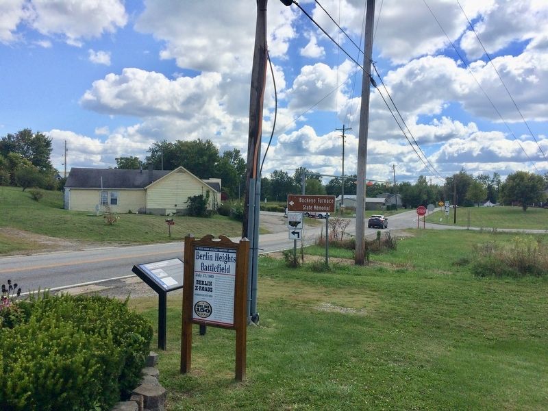
On Ohio Route 327 north of Route 124, on the right when traveling south.
During the Civil War at this location
the Confederate forces of General Johm
Hunt Morgan fought and defeated
Union forces under the command of
Col. Benjamin P. Runkle. Each side
consisted of approximately 1.500 men
The engagement began at 1:00 . . . — — Map (db m108273) HM
On Broadway Street 0.5 miles west of U.S. 35, on the left when traveling west.
Side A: James Cemetery
Major John James (1772-1854) established James Cemetery in 1828 on and around a Native American mound that is the only significant ancient mound remaining in the city of Jackson. The mound is about 70 feet in diameter . . . — — Map (db m24758) HM
On Pennsylvania Route 168 0.4 miles north of Route 18, on the right when traveling south.
Levi Dungan, first settler of Hanover Township, blazed out a 1000 acre tract in 1772. The log cabin and a fine spring were surrounded by the stockade. His wife, Mary Davis, journied by horseback to Philadelphia in 1789 to secure the land patent. — — Map (db m49701) HM
On Main Street north of Broadway Street, on the right when traveling north.
Commercial Apple Orchards in Jackson County. The first commercial apple orchards were established in Jackson
County in the late nineteenth century, although legend has it that
Johnny Appleseed planted the first apple trees here around . . . — — Map (db m123685) HM
On Lawrence Street at 5th Street, on the left when traveling east on Lawrence Street.
John Campbell (1818-1891), founder of Ironton, was an ironmaster and president of the Ohio Iron & Coal Company, a Presbyterian, and an abolitionist. This house and barn, which he built in 1850, became a stop on the Underground Railroad for . . . — — Map (db m59375) HM
On Buckeye Road (County Road 165) 0.1 miles east of Buckeye Park Road (County Road 167), on the right when traveling east.
The covered bridge era in America was from the nineteenth century. The last covered bridge of this period was built by the State of Ohio in Vinton County in 1919, Bridges were enclosed to protect the wooden structural parts and decks from rain . . . — — Map (db m308672) HM
Near South 9th Street at Washington Street, on the right when traveling north.
St. Lawrence O'Toole Catholic Church Corner of 6th and Center Streets, Ironton Built in 1892, this beautiful Catholic church, as well as the Depot (below) and several other historic buildings are part of a self-guided walking tour of historic . . . — — Map (db m310299) HM
On North Central Avenue south of East Wood Street, on the left when traveling south.
In 1834, Joseph Smith, prophet of the Church of Jesus Christ of Latter-Day Saints (LDS), together with about 200 LDS Volunteers from Kirtland, Ohio, marched to assist threatened church members in Jackson County, Missouri. Called “Zion’s . . . — — Map (db m23351) HM
On 1st Avenue east of Court Street, on the right when traveling north.
The Landing of the Welsh in Gallipolis. On April 1, 1818, six families from the Cilcennin area of Mid-Wales sailed from Aberaeron, Wales to Baltimore. The group of 36 people was led by John Jones Tirbach. From Baltimore they traveled to . . . — — Map (db m312391) HM
On Main Street (Ohio Route 93), on the left when traveling east.
Scioto Salt Licks. The Scioto Salts Licks, located in and around Jackson, is an area where naturally occurring salt water, known as brine, flowed to the surface as a salt-water spring. It is known that the spring existed since the Pleistocene . . . — — Map (db m24767) HM
On Park Road (Local Highway 224) 0.4 miles west of Raysville Road (Local Highway 29), on the right when traveling east.
One of the finest examples of ancient petroglyphs in Ohio
is engraved on the exposed rock protected by the shelter
house. Ancestors of American Indians carved these figures
onto this outcrop of the Sharon Sandstone bedrock.
This sandstone is . . . — — Map (db m166701) HM
Near North Blackford Street near Indianapolis Cultural Trail, on the right when traveling north.
The Jackson Washington State Forest offers spectacular vistas of wooded hills and filled fields. The tranquility was disrupted in the fall of 1866 when the nation's first train robbery took place near Seymour. The Reno Gang, who lived in Jackson . . . — — Map (db m238780) HM
On Main Street (Ohio Route 93) west of Broadway Street, on the right when traveling west.
•Established Ohio’s System of Two-Year & Technical Colleges
• Former President of the American Athletic Union “AAU”
• Increased state support for medical education
• “Jim Rhodes is the fastest wit I’ve ever met.” . . . — — Map (db m123814) HM
On Buckeye Park Road (County Road 167) 0.2 miles north of Ridgeland Road (County Road 165), on the right when traveling east.
The stock shed was used primarily as a storage area for charcoal, which was the fuel used to reduce raw iron to a molten state.
[Caption:]
Monroe Furnace in Jackson County was the largest blast furnace in southeastern Ohio, . . . — — Map (db m313004) HM
On Moriah Road at Cherry Fork Road, on the right when traveling north on Moriah Road.
Moriah Church "The Mother of Welsh Churches". Moriah Calvinistic Methodist Church was organized on November 23, 1835, in the home of Daniel Edwards, Brynele. Although Welsh settled Gallia County in 1818, they did not build a . . . — — Map (db m308607) HM
On North Grundy Highway north of Dodson Branch Highway, on the left when traveling north.
North of this marker lies the site of Old Columbus,
once an important landing on the Cumberland
River. In the winter of 1863–1864, the war
had disastrous consequences for this river village.
Late in December 1863, Gen. Ulysses . . . — — Map (db m68344) HM
On North Court Street north of Main Street (U.S. 33), on the right when traveling north.
Pfost-Greene Murders. On November 3, 1897, John Morgan murdered Chloe Greene and two of her three children, James Greene and Matilda Pfost. Daughter Alice Pfost managed to escape despite being wounded during the attack. G.W. Shamblen captured . . . — — Map (db m124858) HM
On North Court Street just north of West Main Street (U.S. 33), on the left when traveling north.
Jackson County was created by an act of the Virginia Assembly on March 1, 1831 and named for President Andrew Jackson.
The first courthouse was a brick structure. The land for the courthouse square was donated by Jacob Starcher, one of the . . . — — Map (db m178574) HM
On East Cross Street, on the right when traveling west.
The railroad came to Ypsilanti in 1838. The inaugural ride was truly a distinguished party that included the 19 year old "Boy Governor," Stevens T. Mason and John D. Pierce, the first State Superintendent of Education. Their arrival on a cold . . . — — Map (db m103371) HM
On Court Street north of Main Street (U.S. 33), on the right when traveling north. Reported permanently removed.
Jackson County was created by an act of the Virginia Assembly on March 1, 1831, and named in honor of President Andrew Jackson.
The first courthouse on this site was a brick structure. The land for the courthouse square was donated by Jacob . . . — — Map (db m11439) HM
On Campbell Drive south of South Liberty Parkway, on the right when traveling south.
The Testimony of Eight Witnesses
Be it known unto all nations, kindreds, tongues, and people, unto whom this work shall come that Joseph Smith Jun. the translator of this work has shown unto us the plates of which hath been spoken. Which have . . . — — Map (db m311688) HM
Thin black lines indicate changes in relevance. Between each pair of lines entries are ordered geographically but all have the same relevance.
* Inflectional forms of words are their plurals, singulars, and possessives as well as gramatical tenses and similar variations.