On Golf Lane (Old Fort Street), on the right when traveling north. Reported missing.
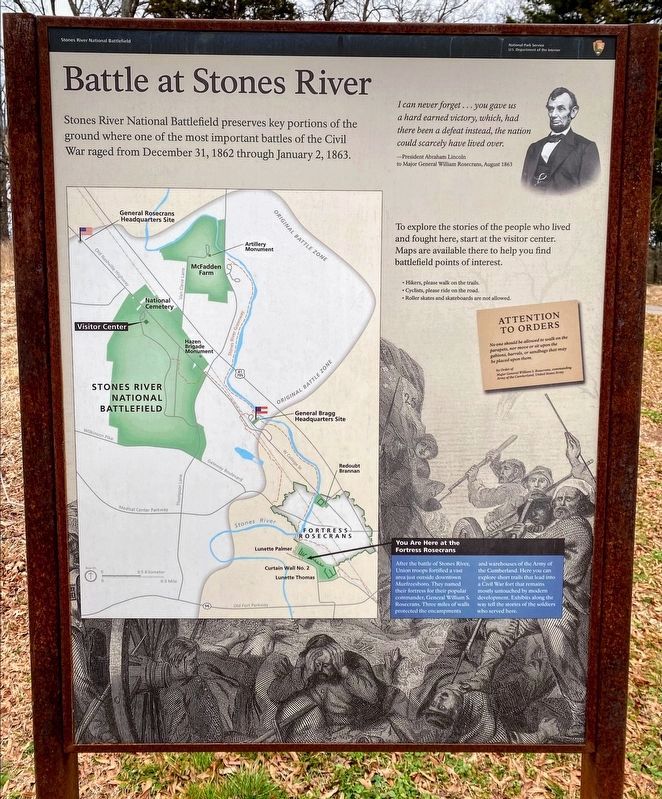
Stones River National Battlefield preserves some key portions of the ground where two great armies of Americans - some 81,000 men - clashed with each other. Their bitter, three-day struggle erupted on New Year's Eve 1862.
To explore their . . . — — Map (db m37762) HM
On Golf Lane (Old Fort Street), on the right when traveling north. Reported missing.
The mounds in front of you are the remains of the largest earthen fortification built during the Civil War. Constructed in 1863 after the Battle of Stones River, Fortress Rosecrans protected the huge Union supply depot at Murfreesboro. It included . . . — — Map (db m168576) HM
Near Golf Lane (Old Fort Street), on the right when traveling north.
At the end of 1863, more than fifty cannon stood ready to defend Fortress Rosecrans. Five, including one 8-inch siege howitzer, were assigned to Lunette Palmer. The lunettes of Fortress Rosecrans were primarily artillery platforms. The ground in . . . — — Map (db m82456) HM
Near Golf Lane (Old Fort Street), on the right when traveling north.
Civil War fortifications were precisely designed. Every angle, every mound of earth, and every slope you see here in Lunette Palmer had a specific purpose. Lunette Palmer is a multi-sided, angled earthwork that projects outward from the basic . . . — — Map (db m37804) HM
Near Golf Lane (Old Fort Street), on the right when traveling north.
"Nearly every house in the place is filled with government stores. There is a pile of meat larger than our house, besides flour, hay, corn, coffee, rice, sugar, salt, tea, vinegar, etc. etc.... If one family of ten persons had these rations to . . . — — Map (db m37837) HM
On Golf Lane (Old Fort Street), on the right when traveling north.
For nearly five months, thousands of soldiers and African-American laborers worked around the clock to build Fortress Rosecrans - digging, shaping, and compacting the works. It was backbreaking, highly unpopular duty. "Feb. 1, 1863. [Building . . . — — Map (db m37847) HM
Near Golf Lane (Old Fort Street), on the right when traveling north.
Looking over this parapet, you can still see some 1,400 feet of earthwork walls stretching out before you. In 1863 Fortress Rosecrans had more than 14,000 feet of walls surrounding a compound that covered 200 acres. Lunette Thomas This earthwork . . . — — Map (db m37864) HM
Near Golf Lane (Old Fort Street), on the right when traveling north.
In the months after this fort was built, thousands of men from Middle Tennessee joined eight new federal infantry regiments. Black men in blue coats guarded the railroad that fed Fortress Rosecrans, and helped garrison Nashville and Chattanooga. By . . . — — Map (db m37867) HM
Near Golf Lane (Old Fort Street) at Overall Street, on the right when traveling north.
The citizens of occupied Murfreesboro had constant reminders of the powerful federal army entrenched here on their doorsteps. From January 1863 to April 1866, "the streets were crowded at all times with wagons and soldiers....Soldiers camping thick . . . — — Map (db m37889) HM
Near Golf Lane (Old Fort Street) at Overall Road, on the right when traveling north.
[Our fortress] consists of a line of works called "lunettes" forming an irregular circle on both sides of Stones River. The "lunette" is a fortification having embankment, ditch, angles, and so forth in front, but open to the rear. Some of [the] . . . — — Map (db m37895) HM
Near Golf Lane (Old Fort Street), on the right when traveling north.
To find such a wide break in a fort's wall seems strange to a person today. Yet the gap you see here - then called a sortie passage - is a carefully calculated part of the defenses of Fortress Rosecrans. The area close to the walls was covered . . . — — Map (db m37896) HM
On West College Street, on the right when traveling south.
Stones River National Battlefield preserves some key portions of the ground where two great armies of Americans - some 81,000 men - clashed with each other. Their bitter, three-day struggle erupted on New Year's Eve 1862. To explore their stories, . . . — — Map (db m37666) HM
On West College Street, on the right when traveling south.
... scattered about on the most commanding positions inside the [fortress] are four or five "redoubts" or small square forts, mounting heavy siege guns, which completely command the lunettes and also the surrounding country. These works are all . . . — — Map (db m37668) HM
Near West College Street, on the right when traveling south.
Those things [you see] inside the fort ... this shape + ... are bum [bomb] proof stockades. The outside line is heavy oak timber hewn on 3 sides ... about 10 feet high. The timber is .. set up end ways and firmly secured .... The top is first . . . — — Map (db m82455) HM
Near West College Street, on the right when traveling south.
Locomotive and train arrived from Nashville today... The shrill whistle evoked hearted cheers from all quarters of our camps. It conveyed to us... that we are linked again with home and friends by an iron roadway over which may come plentiful . . . — — Map (db m82588) HM
On West College Street, on the right when traveling north.
Stones River National Battlefield preserves some key portions of the ground where two great armies of Americans - some 81,000 men - clashed with each other. Their bitter, three-day struggle erupted on New Year's Eve 1862.
To explore their . . . — — Map (db m37694) HM