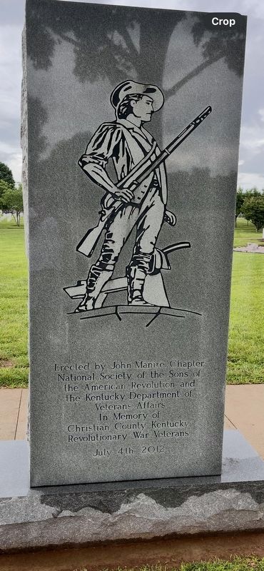
On Fort Campbell Blvd. 2 miles east of Novadell Way, on the left when traveling east.
Sons of the American Revolution
Veterans of the American Revolution
Anderson, John Pvt NC •
Bagby, Richard Sol NY •
Barnes, George Pvt VA •
Bennett, Walter Sur VA •
Boyd, John Ens VA •
Brewer, Henry Pvt NC •
Brewer, Jerry Pvt NC . . . — — Map (db m275626) WM
On Cox Mill Road (State Highway 695) 0.3 miles south of Pierce Lane, on the right when traveling north.
Built 1878 by the Grange. Used ever since for public meetings. Kentucky's first farm cooperative, the Church Hill Grange operated a livestock market here. Leading this pioneer cooperative were two Christian County farmers, Winston J. Davie, first . . . — — Map (db m158702) HM
On Palmyra Road (State Road 345) 0.8 miles south of Fentress Lane, on the right when traveling south.
Winston Jones Davie, 1824-87, home and burial site. Native of Christian County. He was Kentucky's first Commissioner of Agriculture, 1876-79. Appointed by Gov. James B. McCreary. Davie was outstanding farmer, banker, legislator, agricultural writer. . . . — — Map (db m165480) HM
On South Main Street (U.S. 41) at Court Street, on the right when traveling south on South Main Street.
1861-1865
Erected by Christian Co. Chapter No. 590 United Daughters of the Confederacy
In honor of the Confederate soldiers from Christian Co. Kentucky
October 1911. — — Map (db m241836) WM
On Shelbyville Road (U.S. 60) at Whipps Mill Road, on the right when traveling west on Shelbyville Road.
Fort William
Established in 1785 by William Christian and his wife, Anne, a sister of Patrick Henry. On this site one of earliest stone houses in Kentucky was a famous tavern, The Eight Mile House, on Harrods Trace to Falls of the Ohio. From . . . — — Map (db m161983) HM
Near East Jackson Street east of South 16th Street, on the right when traveling east.
Born in North Carolina to Andrew and Elizabeth (Stevenson) McKenzie, Mary Eveline McKenzie met her future husband, Josiah Hughes Bell, while visiting her aunt and uncle in Christian County, Kentucky, where her family helped found Little River . . . — — Map (db m172994) HM
On East Chimney Road at Mayberry Road (County Highway 2842), on the right when traveling south on East Chimney Road.
John Davis Bradburn (1787-1842) was born in Virginia and reared in Kentucky. He entered Mexico in 1817 with Francisco Mina's Army to help upset Spanish colonial forces in the War of Independence. He became a naturalized Mexican citizen and in 1821 . . . — — Map (db m224222) HM
On North Harrison Street at West Main Street, on the left when traveling south on North Harrison Street.
Here on December 1, 1906, began Black Patch War, which lasted to the end of 1908. “Night Riders” fought against non-cooperative farmers and businessmen who opposed the dark tobacco pool. — — Map (db m79151) HM WM
On Lafayette Road (Kentucky Route 107) at Herndon Street, on the left when traveling north on Lafayette Road.
The dream of central-station electricity became a reality for 165 homes in the southern part of Christian County when a switch was thrown at this spot on the night of September 2nd, 1938. These 165 homes were the first members to be served by the . . . — — Map (db m123636) HM
On West Main Cross Street at South Washington Street, on the left when traveling west on West Main Cross Street.
Lincoln was in the General Assembly in 1839 and helped engineer the creation of Dane County at the best of area friends Taylorville was a location without the least sign
of habitation, but landowner Daniel C. Goode convinced the appointed . . . — — Map (db m237582) HM
On West Main Cross Street at South Washington Street, on the left when traveling west on West Main Cross Street.
“I had pleasant accommodations at Taylorville in company with Mr. Lincoln & Mr. Thorton,” Circuit Judge David Davis once wrote from here.
He found this town–the last county seat on his circuit route–to be . . . — — Map (db m12208) HM
On South Main Street at East 14th Street, on the right when traveling north on South Main Street.
1849: Constructed in 1848-1849, the Dillard Campbell House is the most sophisticated example of Greek Revival residential architecture in Christian County. Daniel Umbenhour of Bowling Green constructed the home inspired by nationally . . . — — Map (db m241875) HM
On East 9th Street at Liberty Street, on the right when traveling east on East 9th Street.
It would seemingly be impossible to erect a better building. – Kentucky New Era, March 1, 1915
1915: The U.S. Post Office opened with great fanfare on Feb. 27, 1915. Constructed over a 15-month period, the . . . — — Map (db m241842) HM
Thin black lines indicate changes in relevance. Between each pair of lines entries are ordered geographically but all have the same relevance.
* Inflectional forms of words are their plurals, singulars, and possessives as well as gramatical tenses and similar variations.