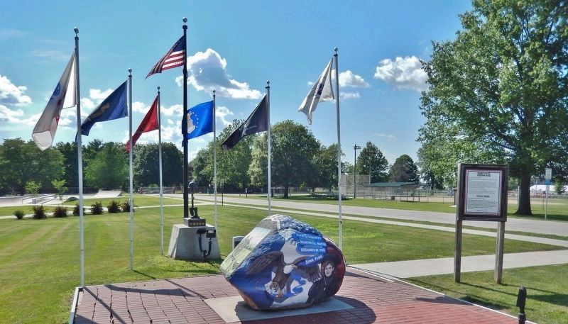
On North Lincoln Street (Iowa Route 14) at Jones Street, on the left when traveling north on North Lincoln Street.
Understanding the Freedom Rock: East Side of the Rock is dedicated to the creator of the Iowa Flag, Dixie Cornell Gebhardt. The West side of the Rock is dedicated to the 6th Governor of Iowa, William Milo Stone of Marion County. Stone, a good . . . — — Map (db m177168) HM WM
On East Robinson Street just east of South 3rd Street, on the right when traveling east.
[side 1] Was named for her southern heritage. Her patriotic contributions made Knoxville the “Birthplace of the Iowa Flag”. Mrs. Gebhardt, who was DAR State Regent in 1917, appointed a flag committee who, after soliciting more . . . — — Map (db m188161) HM
On Highway G 40 (County Highway G40) at 115th Place, on the right when traveling west on Highway G 40.
crossed north to south near this point.
The line was established by treaty to define the separation between the Indian land and that opened to settlers. The line was patrolled by army dragoons from 1842-1845 to enforce the treaty. It ran north . . . — — Map (db m236536) HM
Near Lincoln Street west of Houston Avenue, on the right when traveling west.
The Baptist Church has had a presence in Iowa since the territory was opened for settlement. Moses J. Post was an ordained Baptist missionary/itinerant preacher who traversed southeastern Iowa starting in 1841. Marion County, in which Pella is . . . — — Map (db m236384) HM
Near Lincoln Street west of Houston Avenue, on the right when traveling west.
The history of Pella goes back much further than the settlement of Pella in 1847. The Pella-area's Native American history precedes its Dutch history as the Sac and Fox tribes lived nearby. The Sac became their Americanized name, but they called . . . — — Map (db m236379) HM
On Lincoln Street west of Houston Avenue, on the right when traveling west.
The Tuttle Cabin is named for Thomas and Nancy Tuttle, the first pioneer couple to settle at what would later become the city of Pella.
In 1842, the U.S. Government purchased eleven milion acres of the Iowa Territory from the Sauk and Mesquakie . . . — — Map (db m236373) HM
On Hickory Lane 0.5 miles south of Erbe Drive, on the left when traveling west.
Red Rock Line
The Red Rock Line was a boundary separating the Sac and Fox Indian tribes from the white settlers expanding westward. The survey of this line began near this monument, on the red sandstone bluffs north of the Des Moines River, . . . — — Map (db m236534) HM
Near Lincoln Street west of Houston Avenue, on the right when traveling west.
On the morning of April 12, 1861, South Carolina began firing on the Federal fortress in Charleston Harbor, South Carolina. Within 24 hours, Iowa and Pella became involved. When the first call came for volunteers on April 15, 1861, the citizens of . . . — — Map (db m236386) HM
On Main Street at Huber Street, on the right when traveling south on Main Street.
In the spring of 1847 four sailing vessels carrying 800 freedom-seeking Hollanders landed at Baltimore. They were met by Dominie Henry Peter Scholte, their faithful leader, who led them across the Alleghenies to Pittsburgh and down the Ohio and . . . — — Map (db m235885) HM
On State Highway JJ 0.6 miles south of State Highway Z, on the right when traveling north.
The July 28, 1862, Battle of Moore's Mill opened about one-eighth mile south along the Moore's Mill-Galbreath Mill road, near today's State Road JJ. This area then was heavily timbered.
Lying in ambush east of the road were about 260 . . . — — Map (db m207957) HM
Near Lincoln Street west of Houston Avenue, on the right when traveling west.
When Pella was founded in 1847, transportation and shipping were limited to horse-drawn conveyances. Consequently, mercantile trade and the importing or exporting of goods was extremely limited and expensive. Money was also scarce, as almost every . . . — — Map (db m236385) HM
Thin black lines indicate changes in relevance. Between each pair of lines entries are ordered geographically but all have the same relevance.
* Inflectional forms of words are their plurals, singulars, and possessives as well as gramatical tenses and similar variations.