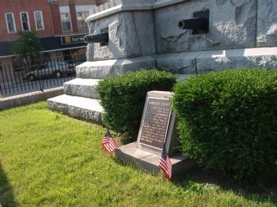
On West Washington Street (a.k.a. St. Rd. 32) at South Main Street, on the right when traveling east on West Washington Street (a.k.a. St. Rd. 32).
Established in 1818 and was split off the north end of Wayne County with Winchester made the County Seat. 1820 - 1825 the County included all Territory North to the Michigan Line. Until 1836, included Territory North to Allen County. The 1875 . . . — — Map (db m31376) HM
On West Washington Street (State Road 32) at South Meridian Street, on the right when traveling east on West Washington Street.
( Front - Plaque )
1917 ― 1918
In honor of the World War Heroes of
Randolph County who made the Supreme
Sacrifice for their beloved Country.
( Row One )
Hershel W. Arens • Clarence W. Borror • Chauncey C. . . . — — Map (db m31464) WM
Near West Franklin Street at South Main Street, on the right when traveling west.
In addition to being the home of Indiana governors Isaac P. Gray (1828-1895) and James P. Goodrich (1864-1940), Randolph County has been the launching point for many other important state and national political and governmental leaders and jurists. . . . — — Map (db m222259) HM
On West Franklin Street west of South Main Street, on the right when traveling west.
Randolph County's long and distinguished contributions to military action date back to the time of the nation's founding. Several Revolutionary War soldiers are buried in the county as well as soldiers who fought in the Battle of 1812. During the . . . — — Map (db m222274) HM
On State Road 32 at County Road N 100 E, on the right when traveling east on State Road 32.
Indiana laws passed 1897 - 1907 provided for abandonment of rural one-room schools; they were replaced with consolidated schools that offered graded curriculum, high school education, and athletics. Driver, Superintendent of Randolph County Schools, . . . — — Map (db m31326) HM
On West Franklin Street at South Main Street, on the right when traveling west on West Franklin Street.
The Indiana General Assembly authorized the formation of Randolph County from Wayne County in January 1818 to take effect in August 1818. Early historians contend that the county's name came from settlers who relocated from Randolph County, North . . . — — Map (db m225004) HM
On West Franklin Street west of South Main Street, on the right when traveling west.
During the early pioneer years of the county, transportation by foot horseback or by raft on the Mississinewa River and White River were the only sources of mobility. However, beginning in the early 1850s the planning for five railroads took . . . — — Map (db m222257) HM
On West Franklin Street at South Main Street, on the right when traveling west on West Franklin Street.
Beginning as early as the 1840s, Randolph County has played a leading role in promoting educational endeavors throughout east central Indiana, the state, and the nation. The Union Literary Institute, founded by members of the Society of Friends . . . — — Map (db m225007) HM
On West Franklin Street at South Main Street, on the right when traveling west on West Franklin Street.
Randolph County's contributions to the arts and sciences are truly remarkable. Poet James Whitcomb Riley's (1849-1916) grandparents lived near Ridgeville and passed away in Randolph County his parents also lived in the county before moving to . . . — — Map (db m222255) HM
On West Franklin Street west of South Main Street, on the right when traveling west.
While it seems almost unfathomable today, 8,000 to 12,000 years ago the Randolph County of today was home to mastodons, woolly mammoths giant beavers, giant ground sloths, giant short-faced bears, and saber-toothed tigers. Fossil remains of these . . . — — Map (db m222276) HM
On Stingley Road (County Route 57) 0.2 miles west of Smith Road (County Route 386), on the left when traveling west.
James and Sophia Clemens’ lives are part of a story of tens of thousands of people of color who migrated north in search of land to farm and better lives during the first half of the 19th century. In 1818, James Clemens (1781-1870) purchased 387 . . . — — Map (db m168860) HM
On Union City Gateway Trail east of South Market Street, on the left when traveling east.
The Union City, Ohio Fire Department was first organized around 1854. At that time, firefighting consisted of volunteers with leather fire buckets and hooked ladders. About 1864, the department purchased a hose cart, which was transported by . . . — — Map (db m228391) HM
On St. Leo's Road (County Route 23) north of Bluff Road.
George Fisher, early Illinois physician, served as sheriff of Randolph County, member of the first House of Representatives of Indiana Territory, Speaker of the House in the first and third Illinois Territorial Assemblies, (1812-1814, 1816-1818), . . . — — Map (db m161312) HM
On Main Street (Illinois Route 3) at Route 155, on the right when traveling south on Main Street.
Dr. George Fisher, Kaskaskia physician, lived on a farm eight miles west of here from 1806 until his death in 1820. 1801 First Sheriff of Randolph County, 1805-1808 Member of the first and second General Assemblies of Indiana Territory, 1812-1816 . . . — — Map (db m161315) HM
Near College Avenue 0.5 miles east of East Main Street, on the right when traveling west.
Goodrich, a hay and grain dealer from Randolph County, Indiana, was a member of the Hanover College Board of Trustees from 1921 to 1951, serving as the Board’s President from 1930 to 1948. His contributions to the College totaled almost $2,000,000 . . . — — Map (db m193805) HM
On West Franklin Street at South Main Street, on the right when traveling west on West Franklin Street.
He was a lawyer, businessman, and descendant of the Goodrich family that settled in Randolph County in 1832. He served as Governor from 1917 to 1921, during which time he established many of the State's departments such as banking, highways and . . . — — Map (db m222247) HM
On West Franklin Street at South Main Street, on the right when traveling west on West Franklin Street.
Established by Frank E. Funk (1887-1963) in 1914, the Winchester Race Track is the nation's second oldest on-going race track and its fastest one-half mile race track. In the early and middle years of the 20th century, Mill's Lake and Funk's Lake, . . . — — Map (db m225005) HM
On West Franklin Street at South Main Street, on the right when traveling west on West Franklin Street.
Randolph County was organized in 1818 two years after Indiana became a state. The county was named for Peyton Randolph, the 1st President of the Continental Congress. It stretched north
to the Michigan line and included all present counties in . . . — — Map (db m222250) HM
He is ranked among the representative citizens of Los Angeles County. He left Missouri in 1849 and settled in Santa Clara County. He came to Southern California in 1869 and purchased 325 acres of the old Dalton Tract, near El Monte. His family . . . — — Map (db m152637) HM
Thin black lines indicate changes in relevance. Between each pair of lines entries are ordered geographically but all have the same relevance.
* Inflectional forms of words are their plurals, singulars, and possessives as well as gramatical tenses and similar variations.