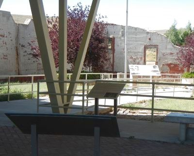
On Main Street (Route 371) near Berta Street, on the left when traveling north.
Unions were established in the Wyoming coal fields for several reasons. In part, they developed due to the dangers found underground in coal mines, the lack of fair wages and the fact that coal companies often controlled a man's life from cradle to . . . — — Map (db m92217) HM
On West Flaming Gorge Way near Hillcrest Way, on the left when traveling north.
In the "old days", crossings on the Green River were made using fords (shallow portions of water), ferries and, finally, bridges. A dangerous body water, the Green River was fordable seasonally and only in certain areas. Beginning in 1862, wagons . . . — — Map (db m90040) HM
It was in 1910 that coal mine operations began at Reliance. These mines were operated by the coal mining company of the Union Pacific Railroad. Here, where the tipple now stands, the first coal loading facility was constructed in 1912. The stone . . . — — Map (db m89721) HM
On West Flaming Gorge Way (County Route 374) near Hillcrest Way, on the left when traveling north.
The Green River has long been a workplace for several major industries, providing jobs to many people in the area. Harvest of railroad ties was one of the first to develop. From 1868 to 1945, spring runoff signaled the arrival of the ties and tie . . . — — Map (db m90038) HM
On West Flaming Gorge Way (County Route 374) near Hillcrest Way when traveling north.
Welcome to Green River, Wyoming - a town named for the river below you. This high-desert community was established in 1868 as the Union Pacific Railroad expanded across Wyoming. Throughout history Native Americans, explorers and trappers have . . . — — Map (db m90037) HM
On Main Street (State Highway 371) near Berta Street, on the left when traveling north.
The people who moved into Superior were from diverse ethnic backgrounds. They came from Austria, Slovenia, England, Wales, Scotland, Germany, Italy, Japan and Greece. Other nationalities loved and worked in various Superior . . . — — Map (db m92210) HM
On Main Street (State Highway 371) near Berta Street, on the left when traveling north.
Prospecting revealed that Seams Nos. 3, 1, 7, and 13, the latter also known as the Van Dyke Seam, were of sufficient thickness to justify the development of mines. Preliminary railroad surveys were made up the long canyon from Thayer Junction on the . . . — — Map (db m92213) HM
On Main Street (State Highway 371) near Berta Street, on the left when traveling north.
In 1900, while prospecting was being carried on in the vicinity of Cumberland, Morgan Griffiths, Gus Paulsen and a party of prospectors went northeast from Rock Springs to prospect in Horse Thief Canyon, since outcrops of a promising deposit of coal . . . — — Map (db m92216) HM
Near Main Street (State Highway 371) near Berta Street, on the left when traveling north.
This monument is dedicated to the miners who worked here and especially to those who lost their lives. It is also a monument to the living -- those who ave remained and exemplify the men and women whose independent character created this community. . . . — — Map (db m92235) HM
On Main Street (State Highway 371) near Berta Street, on the left when traveling north.
This map shows the location of the Union Pacific coal mines and coal camps built in the years between 1906 and 1910. The town of South Superior is purposefully left off this map. It was not owned by Union Pacific Coal Company and in this time . . . — — Map (db m92212) HM
On Main Street (State Highway 371) near Berta Street, on the left when traveling north.
Men and machines became the rule within the Superior Coal Field. While mules and horses were used in the early years, by the late 1930's, most of the mines had mechanized loaders, conveyors, and cutters. The cutters under-cut the coal, the loaders . . . — — Map (db m92211) HM
On Capitol Avenue at West 24th Street, on the right when traveling north on Capitol Avenue.
Esther Hobart Morris
by Joel Turner
In honor of the Wyoming
woman who was the
first woman in the United
States of America to hold
judicial office. — — Map (db m249848) HM
On S. Main Street at C Street, on the right when traveling west on S. Main Street.
On June 6, 1929, the Rock Springs Coal "Welcome" sign was lit. The Union Pacific Coal Company Employes' Magazine reported it spanned the Lincoln Highway and was approximately 100 feet from the main line of the Union Pacific Railroad. It was . . . — — Map (db m67811) HM
On South Main Street east of C Street, on the left when traveling east.
On February 3, 1961 around 5:15 p.m., a bus loaded with FMC Corporation employees were returning home to Rock Springs. Approximately 5 miles west of Rock Springs a car passed the bus and lost control on the slippery highway. It crashed head on into . . . — — Map (db m156595) HM
On BLM Road 4102 near County Route 83, on the left when traveling south.
Marking the common boundary of the Louisiana Purchase (1803) The Northwest Territory (1846) and Mexico (1848).
The Site is located where the Continental Divide crosses the 42nd parallel North Latitude. — — Map (db m96678) HM
On BLM Road 4102 near County Route 83, on the left when traveling south.
This site, where the Continental Divide crosses the 42 degree parallel, North Latitude, was first claimed by Spain through the presumptive right of early discoveries and explorations. The area was also a part of Acadia, granted in 1603 by Henry IV . . . — — Map (db m96679) HM
On Oregon Trail near Squaw Road (Federal Route BLM4106).
This point on the trail is called the Parting-of-the-Ways. The trail to the right is the Sublette or Greenwood Cutoff and to the left is the main route of the Oregon, Mormon, and California Trails. The Sublette Cutoff was opened in 1844 because it . . . — — Map (db m96684) HM
On Flaming Gorge Way at North Center Street when traveling north on Flaming Gorge Way.
From Green River, Wyoming on May 24, 1869 Major John Wesley Powell and a group of voyagers set out to discover the mysteries of one of the last unexplored regions in the continental United States--the Green and Colorado Rivers. Powell was a . . . — — Map (db m13099) HM
Thin black lines indicate changes in relevance. Between each pair of lines entries are ordered geographically but all have the same relevance.
* Inflectional forms of words are their plurals, singulars, and possessives as well as gramatical tenses and similar variations.