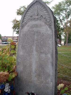
On Main Street south of Jefferson Street, on the left when traveling south.
In memory of Perry County Veterans who gave their lives for their Country
* * * Spanish American * * *
Albert Hemphill
* * * World War I * * *
( Row One )
Albert Bauer • Eugene Bolin • James Bolin • Anthony Bruggeman . . . — — Map (db m47449) WM
On East Rome Road at South Rome Road, on the left when traveling west on East Rome Road.
In 1819, the Perry County Seat was moved to centrally located Rome, a prominent river port at the time. This two-story brick building, echoing the design of the first Indiana Capitol building at Corydon, was built in the town's central square to . . . — — Map (db m171499) HM
On South 7th Street (Indiana Route 66) just north of Taylor Street, on the right when traveling north.
Perry County’s boundaries had changed by 1859. The county offices and courthouse were then moved into a remodeled house in Cannelton to provide a more centrally located county seat. In 1896 this Renaissance Revival building was built to serve as . . . — — Map (db m171730) HM
On Indiana Route 66 just east of County Road 1290E, on the right when traveling east.
These markers were funded with a grant from Federal Highway Administration through the National Scenic Byways Program.
The Hoosier National Forest - Then and Now
This area has been inhabited continuously by humans for 12,000 years. . . . — — Map (db m178232) HM
On Taylor Street just east of South 7th Street ( Route 66), on the left when traveling east.
The central part of southern Indiana has an abundance of rocks. Throughout the nineteenth century and continuing to the present, the extractive industry has benefited from easy access to Ohio River transport. For decades, Perry County tapped the . . . — — Map (db m171729) HM
On West Main Street (Kentucky Route 2200) at Center Street, on the right when traveling west on West Main Street.
Abraham Lincoln, then a lad of 7, with other members of the Thomas Lincoln family crossed the Ohio River on a log raft ferry near here in 1816. The Lincolns were moving to Indiana. — — Map (db m119796) HM
On East Jennings Street at Sycamore Street, on the right when traveling west on East Jennings Street.
Built around 1840 by Thomas P. Gunnell, an Englishman, who came from Philadelphia. He was a blacksmith, dealing in plows, wagons and buggies. He represented this district at the National Convention that nominated Fillmore for President. — — Map (db m207295) HM
Near Eagles Bluff Overlook Park Road north of Indiana Route 66.
The overlook at Cannelton offers a spectacular view of the Ohio River, including the Cannelton locks and dam. The Perry County Parks & Recreation Department has developed a facility on this bluff, called the Eagles Bluff Welcome Center. Eagles . . . — — Map (db m286655) HM
Near North Blackford Street north of Indianapolis Cultural Trail, on the right when traveling north.
Perry County contributes to Indiana's preserved open wilderness with its approximately 60,000 acres the Hoosier National Forest. The Cannelton Locks and Dam, built between 1963 and 1974, assist barges in their navigation of the Ohio River along . . . — — Map (db m238774) HM
Huffman Mill Bridge 1864-65 William T. Washer was contracted with Spencer & Perry Counties, July 1864 to build a 148 foot yellow poplar Burr Arch-Trust Bridge. (Patented by Theodore Burr 1771-1882). Contract payment called for Ten Thousand . . . — — Map (db m56774) HM
Thin black lines indicate changes in relevance. Between each pair of lines entries are ordered geographically but all have the same relevance.
* Inflectional forms of words are their plurals, singulars, and possessives as well as gramatical tenses and similar variations.