THE HISTORICAL
MARKER DATABASE
“Bite-Size Bits of Local, National, and Global History”


7 entries match your criteria.  


Related Historical Markers

Battle of Hampton Roads by Markers.
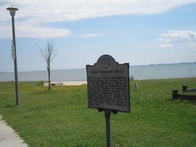
 
By Bill Coughlin, August 11, 2008
Marker at Hampton Roads
SHOWN IN SOURCE-SPECIFIED ORDER
1 ► Virginia, Newport News, South Newport News — Monitor – Merrimack Battle —
On 16th Street (Virginia Route 167), on the left when traveling west.
2 ► Virginia, Newport News, South Newport News — Monitor – Merrimack — The Battle of the Ironclads — 1862 Peninsula Campaign —
On 16th Street (Virginia Route 167), on the left when traveling west.
3 ► Virginia, Hampton, Wythe — W-84 — First Battle of Ironclads
On Chesapeake Avenue (Virginia Route 167) at East Avenue, on the left when traveling west on Chesapeake Avenue. Reported permanently removed.
4 ► Virginia, Norfolk, Fleet — Virginia and Monitor —
On Massey Hughes Drive 0.4 miles Maryland Avenue, on the left when traveling east.
5 ► Virginia, Norfolk, Downtown — The First Battle of Ironclad Ships, 1862 — City of Norfolk —
On Waterside Drive south of Boush Avenue, on the right when traveling south.
6 ► Virginia, Hampton, Wythe — Stalemate in Hampton Roads — In a “big glass case” — 1862 Peninsula Campaign —
On Chesapeake Avenue (Virginia Route 167) at East Avenue, on the left when traveling west on Chesapeake Avenue.
7 ► Virginia, Norfolk, Willoughby Spit — Battle, Monitor and Merrimack —
On West Ocean View Avenue (Virginia Route 168) just east of Richview Street, in the median.
 
 
CeraNet Cloud Computing sponsors the Historical Marker Database.
This website earns income from purchases you make after using our links to Amazon.com. We appreciate your support.
Paid Advertisement
Nov. 11, 2026
