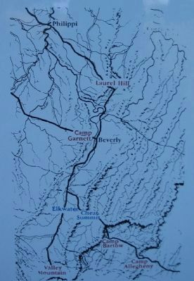
Confederate Stronghold Guarding the Staunton-Parkersburg Turnpike Confederate Brigadier General Robert S. Garnett ordered fortifications built here to control the turnpike and hold western Virginia for the South. The fort, built of earth and . . . — — Map (db m156092) HM
General McClellan marched three brigades of Federal troops into position along nearby Roaring Creek. He ordered a strong scouting party up this road to test the Camp Garnett defenses on July 10, 1861. Withering infantry and artillery fire from the . . . — — Map (db m23636) HM
These earthworks protected Confederates at Camp Garnett from small arms and artillery fire. Soldiers built them by rolling large logs into place and heaping dirt and rocks from a ditch in front. Trees were felled more than 100 yards ahead, their . . . — — Map (db m23616) HM
Confederates built Camp Garnett to block the Staunton-Parkersburg Turnpike. Soldiers here felled trees, dug trenches and stacked rocks for protection. Fortifications covered the hills overloioking this road, forming a fearsome obstacle for . . . — — Map (db m156091) HM
Cannons mounted behind embankments on this hill made Confederate Camp Garnett a formidable position. Placed to sweep the turnpike below, they were 6-pounder smoothbores - light, mobile, and powerful at short range. Four cannons protected the . . . — — Map (db m164655) HM
On July 11, 1861, a Federal flank attack surprised Confederates guarding this pass The battle of Rich Mountain took place here where the Staunton-Parkersburg turnpike crossed the crest of the mountain. About 2:30 pm, the Union forces began . . . — — Map (db m156078) HM
The battle was fought in this pass along the Staunton-Parkersburg Turnpike. Union forces led by General William S. Rosecrans stormed down the hill behind you. Confederates on guard here took cover behind log breastworks, farm buildings and large . . . — — Map (db m23539) HM
General Rosecrans led a brigade of nearly 2,000 Union soldiers through dense wilderness to the summit of Rich Mountain. His guide was young David Hart, son of a family living here at the pass. Leaving camp on Roaring Creek before dawn, Rosecrans' . . . — — Map (db m238863) HM
Here stood the Hart House, surrounded by fierce fighting during the Battle of Rich Mountain. Joseph Hart, grandson of a signer of the Declaration of Independence, was an avid Union supporter who fled with his family when Confederates seized the . . . — — Map (db m23584) HM
(East Side): Battle of Rich Mountain fought here July 11, 1861. In a surprise attack, Gen. W.S. Rosecrans defeated Confederates led by Capt. J.A. deLagnel. Battle was decisive in McClellan's N.W. Virginia campaign. (West Side): Rich . . . — — Map (db m23585) HM
Crozet-Chenoweth Claudius Crozet, a French-born civil engineer formerly in the army of Napoleon, surveyed the Staunton-Parkersburg Turnpike and other major roads, tunnels, and canals in this region. The routes of these historic byways are a . . . — — Map (db m23345) HM