On Range Road 142, 0.4 kilometers south of Township Road 183A Road, on the right when traveling south.
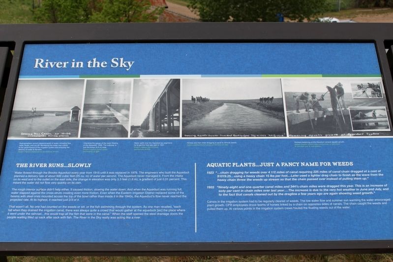
Water flowed through the Brooks Aqueduct every year from 1915 until it was replaced in 1979. The engineers who built the Aqueduct planned a delivery rate of about 900 cubic feet (25 cu. m) of water per second. The Aqueduct never managed it. From the . . . — — Map (db m196947) HM
On Range Road 142, 0.4 kilometers south of Township Road 183A Road, on the right when traveling south.
Getting the water in and out of the Aqueduct wasn't the only challenge. As it marched across the valley it would run smack into the CPR tracks. The Aqueduct as planned was not high enough for trains to go under it. And the construction required to . . . — — Map (db m196952) HM
On Brooks Aqueduct trail, 1.4 kilometers west of Range Road 142.
Many settlers in the Eastern Irrigation Section had a hard time in the 1920s and 1930s. Low grain prices, deteriorating soils from alkali seepage into fields, and inexperience with irrigation farming techniques were some of the problems. Even though . . . — — Map (db m196954) HM
On Brooks Aqueduct trail, 1.4 kilometers west of Range Road 142.
1916 “On April 6 … a camp … was located at the aqueduct for the purpose of tightening and repacking the metal bands at six expansion joints, and also of putting on additional bands … Total cost $160.00.”
1917 “Work was started on . . . — — Map (db m196955) HM
Near Range Road 142, 0.4 kilometers south of Township Road 183A Road, on the right when traveling south.
[English] The CPR built this reinforced concrete aqueduct between 1912 and 1914. It was part of a large irrigation scheme using water diverted from the Bow River to transform 55,000 hectares east of Brooks from semi-arid rangeland to farmland . . . — — Map (db m196937) HM
On Range Road 142, 0.4 kilometers south of Township Road 183A Road, on the right when traveling south.
“So he grabbed hold of a pick, he just kind of lifted it up a bit and then drove it right through, right through the bowl. Well, as the pick went through the bowl his hair stood straight up on end, I can assure . . . — — Map (db m196950) HM
Near Range Road 142, 0.4 kilometers Township Road 183A Road, on the right when traveling south.
In the early 1900s the Canadian Pacific Railroad began construction of a huge irrigation project in Alberta comprising over a million hectares (3 million acres). Part of this original block land grant to the railway is now known as the Eastern . . . — — Map (db m196941) HM