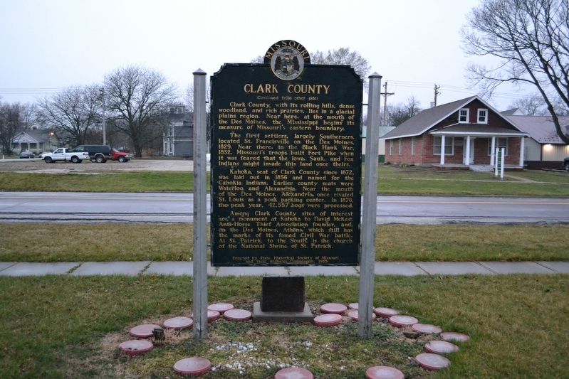
Missouri's first northern border county, organized in 1836, is named for explorer William Clark. In 1839, Iowa Territory and the State of Missouri mobilized troops on the nearby border in a boundary dispute called the Honey War for the bee trees . . . — — Map (db m144553) HM
Nicholas Hilger, like his neighbor Henry Sieben, emigrated from Europe and was drawn to Montana by the promise of possibility. After exploring on his own, he brought his wife and five small children to Montana on a wagon train from Minnesota in . . . — — Map (db m314117) HM
In the early 1860s, the prospect of war divided Missouri. Many of Missouri's settlers came from Southern states. Some owned enslaved people and many held strong views favoring slavery or "Southern rights." Despite this, a statewide convention held . . . — — Map (db m149943) HM
In the spring of 1861, pro-Southern Missouri Gov. Claiborne F. Jackson called up the Missouri State Guard to oppose pro-Union Home Guard and U.S. Army troops. Martin Green, a Lewis County judge, farmer and sawmill operator, answered the call by . . . — — Map (db m149961) HM
Home Guards were groups of pro-Union men who stayed close to their communities to protect against secessionists. These men seldom had army-issued weapons and served without pay.
David Moore recruited and trained the First Northeast Missouri . . . — — Map (db m149939) HM
Clark County was created by the legislature of Missouri Territory on Dec. 15, 1818 and named for the territorial governor, William Clark. It comprised, roughly, all of the present Clark, Hot Spring, Garland, Pike and Dallas counties. Early county . . . — — Map (db m121379) HM
Confederate Manufacturing
Arkadelphia was a manufacturing center for Confederate Arkansas early in the Civil War. Gen. Thomas Hindman established a powder works and an arsenal in 1862, producing guns, cannon, bullets, shells, wagons and . . . — — Map (db m96557) HM
By the 1850s the town had expanded and commercial buildings were being constructed on top of the bluff at Athens. A list of businesses and organizations (circa 1853-1860) reveals the extent of the town's growth.
Wm.B. Armstrong, general . . . — — Map (db m150597) HM
1 • The Fort Henry Monument This monument commemorates the Henry Expedition to the area in 1810-1811. Andrew Henry was the field captain of the St. Louis, Missouri Fur Co. it was a harsh winter. The cabins in the fields just east of . . . — — Map (db m253446) HM
With the United States embroiled in the Civil War, Union leaders feared Mexico might seek to re-take Texas. The Red River Campaign hoped to thwart this possibility and cut off Texas as a source of men and supplies. Union Major General N. P. Banks . . . — — Map (db m274827) HM
York Attends to Sergeant Floyd
William Clark noted on July 30, 1804, that "Serjt. Floyd verry unwell and bad Cold &c..."
On July 31, 1804, Sergeant Floyd wrote in his journal: "I am verry Sick and Has been for somtime but . . . — — Map (db m316429) HM
After the 1786 destruction of the Upper Mad River Shawnee villages, some Mekoches migrated northwest to a bountiful area known as the Grand Glaize along the Maumee River. Others relocated to Indiana, Missouri, and Kansas. However, the cruelty of . . . — — Map (db m307098) HM
( six panels are located beneath the interpretive site shelter:)
A Region Where History Was Made
The scenic routes shown on this map will take you to several historic and scenic landmarks in northeastern Idaho. You will . . . — — Map (db m124526) HM
Two panels make up this marker:
Island Park describes the northern part of Fremont County from the top of the Ashton Hill to the Montana border. Within its borders is an ancient volcanic caldera that has been inactive for the last . . . — — Map (db m109006) HM
Thin black lines indicate changes in relevance. Between each pair of lines entries are ordered geographically but all have the same relevance.
* Inflectional forms of words are their plurals, singulars, and possessives as well as gramatical tenses and similar variations.