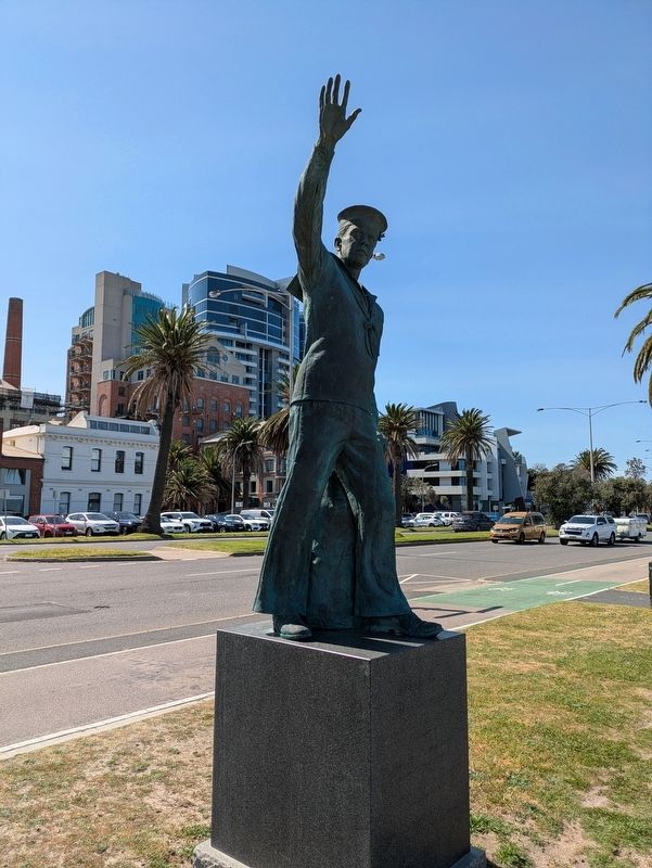
On Beach Street (Victoria Route 33) at Dow Street, on the left when traveling west on Beach Street.
Answering the Call
This Statue was erected by
The Naval Heritage Foundation
of Australia Inc
in Honour and Remembrance of
all Naval Men and Women
who answered the call of their country
in war and peace
Created from . . . — — Map (db m315277) WM
On Waterfront Place at Beach Street, on the left when traveling west on Waterfront Place.
This reinforced concrete pillar is the only remnant of Centenary Bridge and remains on its original site at the St Kilda end of the now demolished bridge. The 305 metre bridge was a continuation of Beach Street, stretching over the four railway . . . — — Map (db m315030) HM
On Waterfront Place 0.1 kilometers west of Beach Street, on the left when traveling west.
(Plaque)
Celebrating the History of Station Pier,
and the Development of Beacon Cove.
'Destinaton'
Sponsored by
The Department of Infrastructure
Office of Major Projects
The Mirvac Group
Artists
Anthony Russo
Mark . . . — — Map (db m314969) HM
On Beach Street 0.1 kilometers west of Bay Street, on the left when traveling west.
Erected By
the Municipality and Citizens
of Port Melbourne.
In Memory of those
who fell in the Great War
1914 - 1918.
“For King and Country" — — Map (db m315040) WM
On Beach Street at Nott Street, on the left when traveling west on Beach Street.
Wilbraham Frederick Evelyn Liardet was acknowledged as the first European settler and Founder of Port Melbourne, (Sandridge) arriving in 1839 with his family.
The family camped on what was known as Liardet's Beach later to become Sandridge, . . . — — Map (db m315035) HM
On Beach Street (Victoria Route 33) 0.1 kilometers east of Dow Street, on the left when traveling west.
Neptune is the most distant gas giant and like Uranus has an atmosphere of hydrogen with some helium and methane. Neptune is the coldest of all the planets and has more methane than Uranus giving it a bluer colour.
Whirling through Neptune's . . . — — Map (db m315279) HM
On Beach Street (Victoria Route 33) at Bay Street ( Route 30), on the left when traveling west on Beach Street.
Port Melbourne is part of the estate of the Yalukut Willam clan of the Boon Wurrung. The Yalukut Willam used fire-stick farming to manage and encourage the growth of the myrnong, a starchy plan that was widely cultivated, making it an important part . . . — — Map (db m315053) HM
On Beach Street at Stokes Street, on the left when traveling east on Beach Street.
The Sandridge Hotel, formally known as the Freemasons' Tavern, was one of the original hotels built along' the foreshore. The first licence was granted to Henry Glynn c1859. The tavern was of brick construction with a slate roof. Henry Glynn was . . . — — Map (db m315034) HM
On Beach Street (Route 33) at Bay Street ( Route 30), on the left when traveling west on Beach Street.
Sandridge Town Pier stood for a century at this site after replacing Captain Wilbrahim Liardet's original 6-tree jetty in 1849. Bristling with masts during the hectic gold rush days, it was soon joined by the 1854 Railway Pier (now Station Pier). A . . . — — Map (db m315054) HM
On Waterfront Place 0.1 kilometers west of Beach Street, on the left when traveling north.
(Upper Marker)
Towering Wharf Cranes
In 1949, two cranes were installed at the seaward end of Station Pier to load and unload visiting ships. The crane in front of you is a reconstruction of one of them.
The straight-jib . . . — — Map (db m315027) HM
On Waterfront Place 0.1 kilometers west of Beach Street, on the left when traveling north.
Station Pier's Historic Milestones
1861 - The first English cricket team to tour Australia arrived here.
1862 - The exhumed remains of explorers Bourke and Wills arrived from Adelaide.
1895 Good Friday - The great . . . — — Map (db m314971) HM
On Beach Road 0.1 kilometers west of Bay Street, on the left when traveling west.
To the Fallen
We Will Remember Them
World War Two 1939 - 1945
Korea 1950 - 1953
Malaya 1950 - 1960
Vietnam 1962 - 1975
Borneo 1963 - 1966
Iraq: The First Gulf War 1990 - 1991
Afghanistan 2001 - 2021
Iraq. The Second Gulf War . . . — — Map (db m315038) HM
On Waterfront Place 0.1 kilometers west of Beach Street, on the left when traveling north.
The earliest inhabitants of the area now known as the City of Port Phillip are the Yalukut Weelam, one of the five clans of the Boon Wurrung, members of the Kulin nation. They originally inhabited the swampy areas below Nerre Nerre Minnim (now South . . . — — Map (db m315029) HM
On Beach Street 0.1 kilometers east of Waterfront Place, on the left when traveling west.
This Memorial
is Erected by Public Subscription
In Honor of the late
Frederick William Maskell
and James McNab
the former Engine Driver, Aged 46 years
and the Latter Fireman, Aged 21 Years
Who lost their lives through
their . . . — — Map (db m315031) HM