On Broad Street just south of Flint Street, on the left when traveling south.
On the occasion of the
first port of call
The City of Brockville expresses tribute and
commemoration to the legendary H.M.S. Bounty
built in Lunenburg, Nova Scotia, Canada
Lost to the sea in November 2012
during Hurricane Sandy . . . — — Map (db m146969) HM
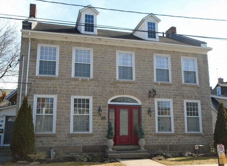
On King Street East (County Highway 2) at Ford Street, on the right when traveling east on King Street East.
Built for William G. Tompkins,
Owned by dentist Dr. William Brace,
his wife Adelia Brace and family from 1895-1909.
This easterly corner unit was purchased in 1911
by Mary and Walter T. Rogers, principal of the
Brockville Business . . . — — Map (db m193809) HM
On Sunday May 21, 1933 the schooner Bluenose, "champion of the North Atlantic fishing fleet" visited Brockville on her way to the Chicago World's Fair. Towed into port by the Canadian Coast Guard vessel Grenville, the ship was visited . . . — — Map (db m141772) HM
This steel caboose was built in 1954 for the Canadian Pacific Railway (C.P.R.) at their Angus Shops in Montréal. It served the Eastern Division of the railway for many years. Cabooses, or "vans" to trainmen, were usually used at the end of freight . . . — — Map (db m87959) HM
On Buell Street just north of King Street West (Provincial Highway 2), on the right when traveling north.
The predecessor of the Brockville Public Library was the Brockville Mechanics' Institute, established in 1842 to provide reading materials and educational opportunities for the town's workingmen. The library was first housed in rented quarters, . . . — — Map (db m146939) HM
On Block House Island Road, 0.1 kilometers south of Water Street East, on the left when traveling south.
Construction of Canada's first railway tunnel, which runs from this point for 1,730 feet in a northerly direction, began in September, 1854. Designed to give the Brockville and Ottawa Railway access to the riverfront, it was opened on December 31, . . . — — Map (db m87075) HM
On Water Street East east of Park Street, on the right when traveling east.
This handsome stone building was built in 1883-84 to house the pumping equipment of the Brockville Water Co., then a private concern. Construction was begun by Montreal contractor Jean B.A. Beigue in November 1883. The president of the water . . . — — Map (db m193823) HM
On Water Street at Ferry Street, on the right when traveling east on Water Street.
They followed the flag
They will not return
"Row of Remembrance"
In loving and proud memory of
A. J. Brister • E. C. H. Moore • J. A. Page
J. A. F. Chapman • H. H. Edwards • E. G. Starr
L. Devine • A. Herron • J. G. Wallace . . . — — Map (db m141672) WM
On King Street West (County Highway 2) at Chase Street, on the right when traveling west on King Street West.
These two significant Main Street buildings stood,
in the past, on the opposite corner site.
The Strathcona Hotel
Built for Thomas Tompkins 1900-01
Destroyed by fire Dec. 27, 1911
[Photo] ca. 1908
The Brock Theatre
Built in . . . — — Map (db m146946) HM
On Block House Island Road, on the right when traveling south.
Underwater explorers regularly gather about 500 yards offshore from the east-end park known as CENTEEN PARK and about a half-mile down stream from here. Below the water, about 65 feet down, lie the remains of the former two-masted wooden schooner, . . . — — Map (db m141820) HM
On Henry Street just south of Water Street West, on the left when traveling south.
The St. Lawrence River was the major transportation route for natural and manufactured goods of all kinds in the 1800s. Many large rafts of hewn logs were assembled on the rivers of Upper Canada near where they were cut down. Oak timber, like the . . . — — Map (db m146975) HM
On King Street West (County Highway 2) at Court House Avenue (County Highway 29), on the right when traveling west on King Street West.
In honoured memory Brockville
who gave their lives
for King and Country
in the Great War
and in grateful remembrance
of those who shared
its dangers
1914 - 1919
1939 - 1945
Korea
1950 - 1953 . . . — — Map (db m146983) HM
On Water Street West at Home Street, on the left when traveling west on Water Street West.
William Buell Sr. (1751-) was one of Brockville's founders and the original landowner of this part of the village. He built and lived with his family in the four different houses he built near this intersection. The house shown here was Buell's . . . — — Map (db m146932) HM
On Home Street at Water Street West, on the right when traveling south on Home Street.
Renowned as the founder of Brockville, Buell was born in Hebron, Connecticut. Shortly after the outbreak of the American Revolution he moved to Québec where he joined the British forces and eventually served as a commissioned officer in the King's . . . — — Map (db m87079) HM
This is one of the earliest maps of the Village of Brockville and shows many of the early details upon which the later Town, and then City of Brockville have been superimposed.
The war of 1812-15 has just been over for a short time. The area . . . — — Map (db m83484) HM
This Memorial is dedicated to all the women and girls for whom violence is a daily reality, to those who have died as a result of violence, and to all the women and men who work to end it.
The Women's Memorial was dedicated on . . . — — Map (db m141684) HM
126 entries matched your criteria. Entries 101 through 126 are listed above. ⊲ Previous 100