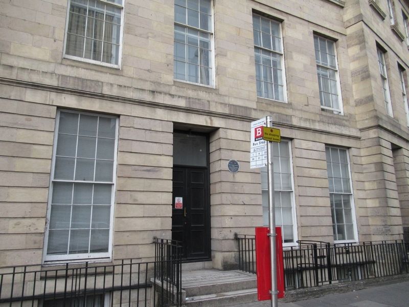
On Clayton Street West at Forth Place, on the left when traveling north on Clayton Street West.
Richard Grainger Bicentenary
1797 1997
36 Clayton Street
West
Home to Richard Grainger
from 1842 to 1861
where he lived with
his children and
servants
City of Newcastle upon Tyne — — Map (db m126502) HM
On The Black Gate at Side, on the right when traveling north on The Black Gate.
Milburn House
Admiral Lord Collingwood
1748 – 1810
Victor of Trafalgar, diplomat, wit
and humanitarian.
Nelson's friend and comrade.
Born in a house on this site
“Since heaven made gentlemen
there is no record of a . . . — — Map (db m126702) HM
Near St. Nicholas Street at The Black Gate, on the right when traveling north.
Anglo-Saxon Church
The remains below are believed to be the tower of a late Anglo-Saxon church. Archaeological excavations between 1977 and 1992 revealed over 600 burials related to the cemetery of this church. It is possible that when the . . . — — Map (db m126787) HM
On Bewick Street at Neville Street (England Route A186), on the right when traveling east on Bewick Street.
The Basil Hume Memorial Garden
This Statue and Memorial Garden were Unveiled on 17 May 2002 by
Her Majesty The Queen
In the year of Her Majesty’s Golden Jubilee
Cardinal Basil Hume OSB, 1923—1999, Benedictine monk and Abbot of . . . — — Map (db m126554) HM
On Bath Lane at Stowell Street, on the right when traveling north on Bath Lane.
Bath Lane
This area outside the West Walls of the old town was known as the Warden's Close. According to the 17th century Newcastle historian, Gray, the Warden's Close formerly contained the house and gardens of the Warden of Tynemouth Priory. Near . . . — — Map (db m126494) HM
On Sandhill (England Route B1600) close to Watergate, on the left when traveling east.
From the above window
on Nov 18th 1772
Bessy Surtees Descended and Eloped with
John Scott later created 1st Earl of Eldon
and Lord Chancellor of England — — Map (db m126790) HM
On St Nicholas Street at Castle Garth, on the right when traveling north on St Nicholas Street.
Castle Keep & Castle Garth
The area surrounding you is a naturally defensible site with steeps sides overlooking and running down to the River Tyne and has been occupied for nearly 2000 years.
From the mid second century the Roman fort of . . . — — Map (db m126880) HM
On St. Nicholas Street close to Cathedral Square, on the right when traveling north.
Cathedral Church of St. Nicholas
The Cathedral Church of St. Nicholas is a Grade I Listed Building and one of the most beautiful and historic buildings in Newcastle. The spire has dominated Newcastle's skyline and served as a prominent . . . — — Map (db m126696) HM
On St. Nicholas Street at Side, on the right when traveling north on St. Nicholas Street.
Charles Avison 1709 – 1776
Considered to be one of the most important English concerto composers of the 18th century, Avison was born, worked and died in Newcastle and is buried in St. Andrew's churchyard, Newcastle.
An organist, . . . — — Map (db m126701) HM
On Grey Street, on the left when traveling north on Grey Street.
This column was erected in 1838
to commemorate
the services rendered to his country by
Charles, Earl Grey, K.G.
who during an active political career of
nearly half a century
was the constant advocate of peace
and the fearless and . . . — — Map (db m126655) HM
On Grey Street at Blackett Street, on the left when traveling north on Grey Street.
Charles, 2nd Earl Grey was British Prime Minister from 1830 to 1834. His Reform Act 1832 helped pave the way for modern democracy. He worked hard to bring about the end of slavery in Britain and its Empire.
Early Life
Born in Fallodon, . . . — — Map (db m126657) HM
On Quayside at Sandhill, on the left when traveling east on Quayside.
This Plaque Was
Erected to Commemorate
The Vist of the
Cutty Sark
Tall Ships Races
Fleet To
Newcastle Quayside
14 – 17 July 1993
Councillor Mrs J. Lamb
The Lord Mayor
Vice Admiral Sir George Vallings
Chairman, S. T. A. . . . — — Map (db m126844) HM
On Westgate Road at St Nicholas’ Street, on the right when traveling west on Westgate Road.
Danish Seamen’s Club
From 1940 to 1945,
Newcastle was the official
home town to 3,000 Danish sailors,
serving in the British Merchant Navy.
St. Nicholas buildings housed
their unions, clubs and the
Danish Merchant Navy
1995
City . . . — — Map (db m126490) HM
On St Andrew’s Street at Stowell Street, on the right when traveling south on St Andrew’s Street.
The Town Wall
Ever Tower
Remains of the late-13th century
Ever Tower, named after the noble
family responsible for its erection.
Used by company of Paviors,
Colliers and Carriagemen
during the 19th century.
Largely demolished
1908 . . . — — Map (db m126555) HM
Near Bath Lane at Stowell Street, on the left when traveling south.
Gallowgate Lead Works
The granite mill-stones that you see today are the legacy of an industry that dominated this site for over 150 years. When it closed in 1933, the Gallowgate Lead Works occupied all the land from this point to almost the end of . . . — — Map (db m126556) HM
On Grey Street at Blackett Street, on the left when traveling north on Grey Street.
Grey’s Monument
Grey's Monument, situated at the head of Newcastle's finest streets and at the heart of the city, is one of Newcastle's most famous landmarks and a popular meeting point. The foundation stone was laid on 6 September 1837. . . . — — Map (db m126656) HM
On Westgate Road at Neville Street (England Route A186), on the left when traveling west on Westgate Road.
Hadrian's Wall
Within this plot, covered by red concrete stand the lower courses of the south face of Hadrian's Wall built first in A.D. 122 from Newcastle upon Tyne to Bowness on Solway, and afterwards extended to Wallsend. A distance in all of 80 . . . — — Map (db m209444) HM
On Grey Street at High Bridge, on the left when traveling north on Grey Street.
53 Grey Street
José Maria de Eça de Quirós
1845 – 1900
Portuguese diplomat and novelist of
European stature. Lived in this building
from 1874 to 1879 – among
the most productive years
of his writing
career.
City of . . . — — Map (db m126694) HM
On Westgate Road at St Nicholas’ Street, on the left when traveling west on Westgate Road.
Robert Stephenson Bi-Centenary
2003
Literary & Philosophical Society
Society established 1793.
This building, designed by John
Green, opened in 1825.
Robert Stephenson was
President of the Society,
1855 – 59
City of Newcastle . . . — — Map (db m126491) HM
On Quayside close to Sandhill, on the left when traveling east.
Newcastle City Councl
Lort Burn
Originally Dene Burn, it became
Lort Burn (dirty burn) from later
14th century. Rising in Leazes it
follows the line of Dean Street
and enters the river near this spot.
High Bridge and Low Bridge
mark . . . — — Map (db m126838) HM
Near St. Nicholas Street at The Black Gate, on the right when traveling north.
Medieval Castle
Late December 1292AD. It has rained heavily overnight but life goes on as usual inside the Castle Garth.
People enter the Garth from the Bailey Gate to go about their business. A wagon full of grain sacks is unloaded to . . . — — Map (db m126786) HM
On Bridge Street at Hadrian’s Wall Path, on the right when traveling south on Bridge Street.
Newcastle Swing Bridge
This bridge completed in June A.D. 1876
Was Built at the Cost of the
Tyne Improvement Commission
consisting in 1876 of the following members, viz:
Life Commissioners
James C. Stevenson M.P. · John Dryden · William R. . . . — — Map (db m126878) HM
Near St. Nicholas Street at The Black Gate, on the right when traveling north.
Norman Castle
1080AD. An autumn sun sets over Robert Curthose's new castle.
To the people outside, the Castle is a statement of royal authority and
conquest. To the Normans it is their safe haven.
Norman soldiers patrol the inner . . . — — Map (db m126785) HM
On Forth Street at Orchard Street, on the right when traveling east on Forth Street.
Orchard Street
The Town Wall turned sharply southwards from the originally intended line at a point near here now under the railway viaduct and ran down to the Close Gate and finally the river.
This stretch of the Town Wall, the section . . . — — Map (db m126648) HM
Near St. Nicholas Street at The Black Gate, on the right when traveling north.
Pons Aelius
A cold winter's evening, just before dusk, 386AD.
The First Cohort of Cornovii are stationed at Pons Aelius. As auxiliary soldiers they protect the only river crossing for miles around.
A handful of soldiers await orders . . . — — Map (db m126784) HM
On Quayside at Watergate, on the left when traveling west on Quayside.
The Roman Bridge across the Tyne at Newcastle
You are standing close to the site of the bridge that gave Newcastle its Roman name – Pons Aelius, meaning ‘the bridge of Hadrian’.
Timbers believed to be foundations of the Roman . . . — — Map (db m126845) HM
On Quayside at Lombard Street, on the left when traveling east on Quayside.
Tyne and Wear County Council
1986
Sailing Ship Owners
Throughout the age of sail, this
Quayside area around Exchange
Buildings (c.1861) was home to
Newcastle's ship owners,
including such men as
R. Beckwith, H. Milvain
and T. . . . — — Map (db m126846) HM
On Westgate Road at St Nicholas’ Street, on the left when traveling west on Westgate Road.
RSC Advancing the Chemical Sciences
National Chemical Landmark
Sir Joseph Wilson Swan FRS
(1828 – 1914)
Chemist, physicist and inventor of the
incandescent light bulb which he
first demonstrated at a public lecture here
on 3 . . . — — Map (db m126492) HM
Near St. Nicholas Street at The Black Gate, on the right when traveling north.
St. Nicholas Cathedral
You are now standing in the heart of Old Newcastle. Beyond the Black Gate you can see the Lantern Tower of the Cathedral Church of St Nicholas.
The Lantern Tower was built in 1448 and is named for the light that . . . — — Map (db m126789) HM
On Grey Street at Shakespeare Street, on the left when traveling north on Grey Street.
Former Turk’s Head Hotel
Suffragette Movement
Meeting place where suffragettes
celebrated the release of Kathleen Brown
from Holloway Prison July 19th 1909
and stopped for refreshments
on the march from
Edinburgh to London,
October . . . — — Map (db m126658) HM
Near St. Nicholas Street at The Black Gate, on the right when traveling north.
The Barbican
The building now known as the Black Gate was originally the barbican of the Castle. A barbican is a heavily defended gateway which sticks out from the main wall. bbn
The barbican was built at an angle to the main wall so that . . . — — Map (db m126705) HM
Near St. Nicholas Street at The Black Gate, on the right when traveling north.
The Black Gate
Built between 1247 and 1250 during the reign of King Henry III, the Black Gate was the last addition to the medieval Castle defences. Now a Scheduled Ancient Monument and Grade I Listed Building it was the gatehouse of the . . . — — Map (db m126704) HM
Near St. Nicholas Street at The Black Gate, on the right when traveling north.
City of Newcastle upon Tyne
1080 1980
The Black gate
Principal gateway to castle
built 1247 – 50.
Upper two storeys
built in seventeenth century.
Restored, notably by
R.J. Johnson
1883 – 84
Tyne and Wear County . . . — — Map (db m126706) HM
On Quayside close to Broad Garth, on the left when traveling east.
39 Quayside
“The Custom House”
Built in 1766 to replace the old
Custom House at Sandhill. Duties from
ships using the Port of Newcastle
were collected here. Altered
and refronted in 1833 by
Sydney Smirke,
Architect. . . . — — Map (db m126849) HM
On Sandhill at Quayside, on the right when traveling east on Sandhill.
Newcastle City Council
The Guildhall
This plaque, unveiled by
Councillor Ian Graham, Lord Mayor
of Newcastle, on 22nd March 2016 on the
original site of the city's governance,
commemorates the beginning of
the 800th year of . . . — — Map (db m126829) HM
On Quayside at Sandhill, on the left when traveling east on Quayside.
The Guildhall
The present building incorporates part of
Robert Trollope's town court of 1655-8.
North front (1796) by William Newton
and David Stephenson. South front
(1809). East end (1823) by John
Dobson, altered 1880. The centre
of . . . — — Map (db m126843) HM
Near St. Nicholas Street, on the right when traveling north.
The Heron Pit
You are currently standing above the Heron Pit which was an underground prison (known popularly as an 'oubliette').
The Pit was built by William Heron, the High Sheriff of Northumberland, to imprison people.
The walls . . . — — Map (db m126771) HM
On Bridge Street close to Hadrian’s Wall Path, on the right when traveling south.
Port of Tyne Historical Information
The Swing Bridge
The Swing Bridge was built by the Tyne Improvement Commission, under powers conferred by the Tyne Improvement Act of 1861, as part of their overall plan to improve navigation and expand . . . — — Map (db m126879) HM
On Stowell Street at Friars Street, on the right when traveling south on Stowell Street.
City of Newcastle upon Tyne
The Town Wall
The Herber Tower, built in the
late thirteenth century, was
restored in 1770 – 1 by the Company
of Armourers, Curriers and
Feltmakers who used the tower
for a meeting hall.
Tyne and . . . — — Map (db m126557) HM
On Quayside close to King Street, on the left when traveling east.
Broad Garth
Thomas Spence
1750 – 1814
Born Quayside, Newcastle.
Utopian writer and land reformer.
Courageous, pioneering campaigner
for the rights of men and women.
Founded a schoolroom and
debating society in Broad Garth. . . . — — Map (db m126847) HM
On Forth Street at Orchard Street, on the right when traveling east on Forth Street.
This section of the thirteenth
century town wall was repaired
by the Civic Services Committee
of the City Council and the
Ministry of Public Building and
Works in 1968. — — Map (db m126649) HM
On Broad Chare at Dog Bank, on the right when traveling north on Broad Chare.
The Master, Pilots and Seamen of the Corporation of the
Trinity House of Newcastle upon Tyne
Trinity House
Site acquired in 1505
by the Guild of the Blessed Trinity of
Newcastle upon Tyne, the original name
of the professional and . . . — — Map (db m126877) HM
On St. Nicholas Street at The Black Gate, on the right when traveling north on St. Nicholas Street.
Turning Bridge
In medieval times the bridge over the Castle's moat would have been a type of drawbridge called a ‘turning bridge’. The bridge could be raised or lowered quickly to allow or prevent access to the Castle gate.
It worked by . . . — — Map (db m126703) HM
On Blandford Square at Sunderland Street, on the right when traveling south on Blandford Square.
In Remembrance of, and Respect for, those Born in Newcastle upon Tyne
Who have been Awarded the Victoria Cross for Valour.
This Memorial was erected by Newcastle City Council on behalf of the People of the City.
Private . . . — — Map (db m126501) HM WM
On St. Nicholas Street at Cathedral Square, on the right when traveling north on St. Nicholas Street.
Victoria R.I.
1837 — 1901
The Throne is established by
Righteousness
Thine O Lord is the Greatness
And the Power and the Glory.
And the Victory and the Majesty
Thine is the Kingdom O Lord and
Thou Art Exaulted as Head above . . . — — Map (db m126697) HM
On Stowell Street at Friars Street, on the right when traveling south on Stowell Street.
West Walls
"The walles here of Newcastle, are a great deal stronger than these of Yorke and not unlike to the walls of Avineon, but especially those of Jerusalem."
(A Just and Exact Discourse upon the Siege and Storming of Newcastle, . . . — — Map (db m126647) HM
Near St. Nicholas Street at The Black Gate, on the right when traveling north.
William Heron - The Hammer of the Poor
1246 AD: William Heron has been made Sheriff of Northumberland and Keeper of Newcastle Castle. He remained in this position until his death in 1258 AD.
Heron has a duty to execute justice and raise . . . — — Map (db m126769) HM