Follow the first Eastbound journey of the Pony Express through California to Genoa, Nevada....To better understand the relationship, study each marker in the order shown.
By Syd Whittle, January 29, 2009
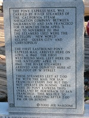
Back of Marker - Pony Express River Steamer “Antelope”
Dedicated April 13, 2000
Sacramento
by
James Stretesky
George E. Kuchler Family
Rotary Club of Sacramento
Burnett & Sons Planing Mill and Lumber Co – Since 1869
Sacramento Traditional Jazz Society
Sacramento Metro Chamber of . . . — — Map (db m15702) HM
On 2nd Street south of I Street, on the left when traveling south.
This structure, erected in 1852-53, was occupied during the 1850’s by the B.F. Hastings Bank, Wells Fargo and Co., various state officials, Sacramento Valley Railroad, and the Alta Telegraph Co. during April 1860 - May 1861. The Alta Telegraph Co. . . . — — Map (db m11388) HM
Departing at 2:45 A.M. from the Alta Telegraph Co. in Sacramento, Pony Rider Sam (Bill) Hamilton carried the first mail eastward of the Central Overland Pony Express on April 4, 1860. Here quickly changing ponies he sped on to the next stop at . . . — — Map (db m19583) HM
On White Rock Road at Gold Valley Drive, on the right when traveling east on White Rock Road.
Owned and operated from 1857 as a stage station by Henry F. W. Deterding. This was the site of the second remount station of the Central Overland Pony Express during March-July 1860. Here on April 4, 1860, Sam (Bill) Hamilton with the first eastward . . . — — Map (db m2034) HM
On PG&E-Clarksville Sub-Station Road, on the right when traveling west.
At this site on the old Clarksville-White Rock Emigrant Road was Mormon Tavern. Constructed in 1849, this popular stage stop was enlarged and operated by Franklin Winchell in 1851. It became a remount station of the Central Overland Pony Express and . . . — — Map (db m12056) HM
On Pleasant Valley Road, on the right when traveling east.
Trading post, emigrant stop, and mining camp of the 1850’s. This became one of the remount stations of the Central Overland Pony Express. Here at the Nevada House on April 13, 1860, pony rider William (Sam) Hamilton changed horses while carrying . . . — — Map (db m11571) HM
On Main Street at Sacramento Street, on the right when traveling east on Main Street.
Gold Rush town and Western Terminus of the Placerville – Carson Road to the Comstock. Placerville was a relay station of the Central Overland Pony Express, April 4, 1860 – June 30, 1861. Here on April 4, 1860 the first east-bound pony . . . — — Map (db m57973) HM
On Pony Express Trail east of Exit 57 (U.S. 50), on the right when traveling east.
This was the site of Sportsman’s Hall, also known as Twelve-Mile House. The hotel operated in the late 1850’s and 1860’s by John and James Blair, a stopping place for stages and teams of the comstock. It became a relay station of the Central . . . — — Map (db m609) HM
On U.S. 50 near Ice House Road, on the right when traveling west.
This was the site of a change station of the Pioneer Stage Company in the 1850’s and 1860’s. During 1860-1861, the Central Overland Pony Express maintained here the first pony remount station east of Sportsman’s Hall. — — Map (db m57977) HM
On Interstate 50, on the left when traveling east.
This was the site of Webster's Sugar Loaf House, well-known stopping place during the Comstock rush. Beginning in April 1860, it was used as a remount station of the Central Overland Pony Express. In 1861 it became a horse change station for . . . — — Map (db m14177) HM
On Highway 50 (U.S. 50) west of Strawberry Lane, on the right when traveling west.
This popular resort and stopping place for stages and teams of the Comstock, established by Swift and Watson in 1856, became a remount station of the Central Overland Pony Express on April 4, 1860. Here on that date division superintendent Bolivar . . . — — Map (db m436) HM
On Old Pony Express Way (California Route 88) east of California Route 89, on the left when traveling east.
Historic Woodfords Station, the Eastern Sierra gateway to the goldfields of California, way station of the famed Pony Express, and entrance to Carson Pass on the Emigrant Trail to the Sacramento Valley. Beginning in 1849 with the building of the . . . — — Map (db m195369) HM
On Old Pony Express Way (California Route 88) east of California Route 89, on the right when traveling east.
During the initial five weeks of its operation in 1860, an important remount station of the famous Pony Express was located a few feet from here at Cary’s Barn.
This monument erected by the Historical Society of Alpine County.
National . . . — — Map (db m143520) HM
On Jacks Valley Road/Main Street (Nevada Route 206), on the right when traveling south.
[Front of Marker:]
Genoa
Original Home Station
April 3, 1860 – Aug. 30, 1860
Relay Station
Sep. 1, 1860 – Nov. 20, 1861
By
Town of Genoa
Genoa Volunteer Fire Department
Carson Valley Historical Society . . . — — Map (db m20663) HM