5 entries match your criteria.
Related Historical Markers
To better understand the relationship, study each marker in the order shown.
By Dale K. Benington, May 3, 2009
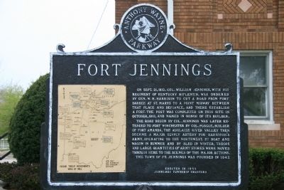
Fort Jennings Marker
SHOWN IN SOURCE-SPECIFIED ORDER
| On North Water Street (Ohio Route 190) south of 4th Street, on the right when traveling north. |
| | Fort Jennings
On Sept. 21, 1812, Col. William Jennings, with his regiment of Kentucky riflemen, was ordered by Gen. W. H. Harrison to cut a road from Fort Barbee at St. Marys to a point midway between that place and Defiance, and there . . . — — Map (db m18782) HM |
| On County Road 171, 0.2 miles south of County Road 177, on the left when traveling north. |
| | One of a chain of posts built
along the Auglaize River by
General William Henry Harrison
in his campaigns against the
British and Indians in the
War of 1812.
Presented to the State of
Ohio in the Sesquicentennial
Year of Statehood. . . . — — Map (db m18954) HM |
| On County Road 171, 0.2 miles south of County Road 177, on the left when traveling north. |
| | Fort Brown was built in 1812 by a "Col. Brown." Together with Fort Jennings and Fort Amanda to the south, and Fort Winchester to the north, it guarded the army supply route into the Maumee Valley. In 1813, Gen. Greene Clay's Kentucky Militia, . . . — — Map (db m18989) HM |
| On West 2nd Street at Washington Avenue, on the right when traveling east on West 2nd Street. |
| |
Built by General Wm. H. Harrison in Oct. 1812 and named for General Winchester.
For a time it was the only defensive work against the British and Indians in Northwestern Ohio. — — Map (db m18717) HM |
| On West Indiana Avenue (State Road 65) at Fort Meigs Road, on the right when traveling south on West Indiana Avenue. |
| |
[Marker Front]:
Fort Meigs
1813
[Marker Reverse]:
In recognition of the services of the gallant men who defended their country on this spot. — — Map (db m19267) HM |
May. 4, 2024