5 entries match your criteria.
Related Historical Markers
To better understand the relationship, study each marker in the order shown.
By Dale K. Benington, May 3, 2009
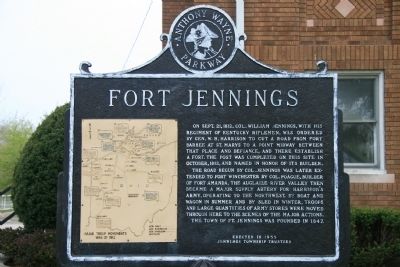
Fort Jennings Marker
SHOWN IN SOURCE-SPECIFIED ORDER
| On North Water Street (Ohio Route 190) south of 4th Street, on the right when traveling north. |
| On County Road 171, 0.2 miles south of County Road 177, on the left when traveling north. |
| On County Road 171, 0.2 miles south of County Road 177, on the left when traveling north. |
| On West 2nd Street at Washington Avenue, on the right when traveling east on West 2nd Street. |
| On West Indiana Avenue (State Road 65) at Fort Meigs Road, on the right when traveling south on West Indiana Avenue. |
May. 18, 2024