6 entries match your criteria.
Related Historical Markers
The list includes all five Prince William County Courthouses in sequence from first through the fifth. Note that there are two markers for the second courthouse.
By Kevin White, September 6, 2007
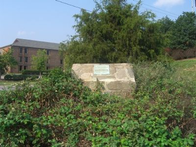
The First Courthouse of Prince William County Marker
SHOWN IN SOURCE-SPECIFIED ORDER
| On Jefferson Davis Highway (U.S. 1) at Annapolis Way, on the right on Jefferson Davis Highway. Reported permanently removed. |
| | One hundred and fifty yards east of this spot stood the first courthouse of Prince William County organized in 1731. This monument erected by the Bicentennial Committee of Prince William County, September 25, 1931, was presented to the people of . . . — — Map (db m2339) HM |
| On Aden Road (County Route 646) at MCB-8, on the right when traveling east on Aden Road. Reported missing. |
| | In 1743, the second Prince William County Courthouse was built near here along Cedar Run, replacing the first county courthouse in Woodbridge. After the creation of Fairfax County, the Cedar Run location, owned by Philemon Waters, became the center . . . — — Map (db m2487) HM |
| Near Quantico Marine Corps Base. |
| | Second Prince William
Court House
1742 - 1760 — — Map (db m237422) HM |
| On South Fairfax Street at Duke Street, on the right when traveling east on South Fairfax Street. |
| | Forty yards southerly of this spot stood the third court house of Prince William County. The brick in this monument came from the foundation of this old court house, and was donated present owners of said court house lot. — — Map (db m2274) HM |
| On Bristow Road (Virginia Route 619) 4.2 miles east of Nokesville Road (Virginia Route 28), on the right when traveling west. |
| |
Fourth seat of the Prince William County government. Courthouse, jail, Episcopal Chapel, and White House were built in 1822 on land originally part of the Brent Town tract confiscated from Robert Bristow, a Tory, in 1779.
♦ St. James . . . — — Map (db m780) HM |
| On Lee Avenue just south of Grant Avenue (Business Virginia Route 234), on the right when traveling south. |
| | The city of Manassas originated in 1852 at the junction of the Manassas Gap and the Orange & Alexandria railroads. During the Civil War the junction’s strategic significance led to two important battles nearby. After the war, as the community grew, . . . — — Map (db m778) HM |
Apr. 26, 2024