On California Route 177 at milepost 17 at Coxcomb Monument Road, on the left when traveling north on State Route 177. Reported missing.
Camp Coxcomb was established at this site in the Spring of 1942. It was one of fifteen such camps built in the southwestern deserts to harden and train United States troops for service on the battlefields of World War II. The Desert Training Center . . . — — Map (db m78513) HM
Near Chiriaco Road north of Interstate 10, on the left when traveling east.
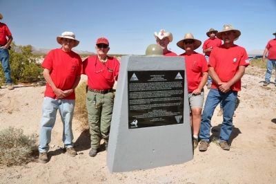
[This is a four sided monument displaying three different markers:]
Front - Facing West:
Desert Training Center
* Camp Young *
Maj. Gen. George S. Patton Jr., U.S. Army, selected Camp Young as headquarters site for the Desert . . . — — Map (db m32139) HM
On California Route 62 at milepost 90.5, on the right when traveling east.
Camp Granite was established at this site in the spring of 1942. It was one of fifteen such camps built in the southwestern deserts to harden and train United States troops for service on the battlefields of World War II. The Desert Training Center . . . — — Map (db m83038) HM
On Desert Center - Rice Road (California Route 62 at milepost 90.7), on the left when traveling east.
Iron Mountain divisional camp was established at this site in the spring of 1942. One of eleven such camps built in the California-Arizona desert to harden and train United States troops for service on the battlefields of World War II. The first . . . — — Map (db m77424) HM
On U.S. 95 at milepost 66,, 10 miles north of Interstate 40, on the right when traveling north.
Camp Ibis was established at this site in the spring of 1942 – one of eleven such camps built in the California – Arizona Desert to harden and train United States Troops for service on the battlefields of World War II.
The 440th AAA . . . — — Map (db m78585) HM
On Interstate 40, 6 miles east of the Essex Road Interchange, on the right when traveling east.
Camp Clipper was established at a site that reached
From Essex Road to this location in the spring of
1942. It was one of twelve such camps built in the
Southwestern Desert to harden and train United
States troops for service on the . . . — — Map (db m72258) HM
On East Imperial Dam Road, 0.5 miles west of U.S. 95, on the right when traveling east.
Camp Laguna operated from April 1942 to April 1944. It was one of twelve such camps built in the southwestern deserts to train United States troops during World War II.
The Desert Training Center, a simulated theater of operations, included . . . — — Map (db m29061) HM
On Ave 64E near Interstate 8, on the left when traveling south.
Camps Hyder & Horn were established 10 miles north of Dateland in the fall of 1943. They were 2 of 15 desert camps built to harden and train United States Troops for service in World War II. The Desert Training Center was a simulated theater of . . . — — Map (db m78546) HM
On Broadway Avenue (Arizona Route 72 at milepost 27) south of Main Street, on the right when traveling west.
General George Patton established Camp Bouse in 1943 in the Butler Valley as the site for training over 5,500 carefully screened and qualified volunteers. These soldiers were trained to use a highly secret weapon called the Canal Defense Light. . . . — — Map (db m29165) HM
On Aqueduct Road (Route 62 at milepost 112.4), on the right when traveling east.
Camp Rice was established at this site in the spring of 1942. It was one of twelve such camps built in the southwestern deserts to harden and train United States troops for service on the battlefields of World War II. The Desert Training Center was . . . — — Map (db m209934) HM
Near Chiriaco Road (Business Interstate 10) just north of Summit Road, on the left when traveling east.
The D.T.C was established by Major General George S. Patton Jr. in response to a need to train American combat troops for battle in North Africa during World War II. The camp, which began operation in 1942 covered 18,000 square miles. It was the . . . — — Map (db m50700) HM
On Broadway Avenue (Arizona Route 72 at milepost 27) south of Main Street, on the right when traveling west.
Camp Bouse was established in Butler Valley 30 miles behind this monument in Sept. of 1943. It was one of twelve such camps built in the southwestern deserts to harden and train United States troops for service on the battlefields of World War II. . . . — — Map (db m78566) HM
On Lanfair Road, 0.1 miles north of Goffs Road, on the left when traveling north.
The U. S. Army maintained a camp at Goffs 1942-1944. Goffs was an important railhead, supply point, hospital, and for three months in 1942 Headquarters of the 7th Infantry Division. That unit went on to distinguish itself in combat in the Aleutians . . . — — Map (db m78523) HM
On Hiwassee Highway (State Highway 60 at milepost 2), 4 miles north of Birchwood Pike (State Road 312), on the right when traveling north.
Around 1809, William Blythe, a Cherokee, established a ferry at this site to provide transportation for the settlers to the west and the Cherokees to the east. During the 1838 Trail of Tears, it was an important crossing, and it played a military . . . — — Map (db m39468) HM