Marker Logo HMdb.org THE HISTORICAL
MARKER DATABASE
“Bite-Size Bits of Local, National, and Global History”


14 entries match your criteria.  


Related Historical Markers

D.R. Jones' Division at Antietam.
 
Longstreet's Command Marker image, Touch for more information
By Brian Scott, September 19, 2015
Longstreet's Command Marker
SHOWN IN SOURCE-SPECIFIED ORDER
1 Maryland, Washington County, Sharpsburg — 323 — Longstreet's CommandAnderson's Brigade, D.R. Jones' Division
On Hagerstown Pike (State Highway 65) at Richardson Avenue, on the right when traveling north on Hagerstown Pike.
C.S.A. Longstreet's Command Anderson's Brigade, D.R. Jones' Division Col. George T. Anderson, 11th Georgia Infantry, Commanding Organization 1st Georgia Infantry (Regulars) 7th Georgia Infantry 8th Georgia Infantry 9th Georgia Infantry 11th . . . Map (db m5468) HM
2 Maryland, Washington County, Sharpsburg — 328 — Longstreet's CommandAnderson's Brigade, D.R. Jones' Division
On Boonsboro Pike (State Highway 34), on the right when traveling east.
C.S.A. Longstreet's Command. Anderson's Brigade, D.R. Jones' Division. Col. George T. Anderson, 11th Georgia Infantry, Commanding. Organization. 1st Georgia Infantry (Regulars.) 7th Georgia Infantry, 8th Georgia Infantry, 9th Georgia Infantry, . . . Map (db m7256) HM
3 Maryland, Washington County, Sharpsburg — 321 — D.R. Jones' Division, Longstreet's Command
On Boonsboro Pike (State Highway 34), on the right when traveling east.
C.S.A. D.R. Jones' Division, Longstreet's Command, Brig. Gen. David R. Jones, Commanding. September 17, 1862. The division formed at daylight on the plateau commanding the approaches to the Burnside Bridge. At about noon the enemy made several . . . Map (db m7257) HM
4 Maryland, Washington County, Sharpsburg — 322 — D.R. Jones' Division, Longstreet's Command
On Boonsboro Pike, on the right when traveling east.
C.S.A. D.R. Jones' Division, Longstreet's Command. Brig. Gen. David R. Jones, Commanding. September 15-16, 1862. This division, composed of the brigades of Toombs, Kempter, Drayton, [J]en[k]ins, Garnett, and George T. Anderson, withdrew from its . . . Map (db m7258) HM
5 Maryland, Washington County, Sharpsburg — 356 — Longstreet's CommandJenkins' Brigade, Jones' Division
On Rodman Avenue, on the right when traveling south.
C.S.A. Longstreet's Command. Jenkin's Brigade, Jones' Division. Col. Joseph Walker, Palmetto (S.C.) Sharpshooters, Commanding. Organization. 1st South Carolina Infantry, 6th South Carolina Infantry 2d South Carolina Rifles, 4th South Carolina . . . Map (db m6506) HM
6 Maryland, Washington County, Sharpsburg — 364 — Longstreet's CommandGarnett's Brigade, Jones' Division
On Rodman Avenue, on the right when traveling south.
C.S.A. Longstreet's Command. Garnett's Brigade, Jones' Division, Brig. Gen. Richard B. Garnett, Commanding. Organization. 8th Virginia Infantry, 19th Virginia Infantry, 18th Virginia Infantry, 28th Virginia Infantry, 56th Virginia Infantry. . . . Map (db m6505) HM
7 Maryland, Washington County, Sharpsburg — 366 — C.S.A.
On Old Burnside Bridge Road, on the right when traveling east.
On the morning of September 17, 1862, this bridge was defended by the 2d and 20th Georgia of Toombs' Brigade and the 50th Georgia of Drayton's Brigade. The 20th Georgia was on the high wooded bluff immediately opposite this end of the Bridge, and . . . Map (db m6472) HM
8 Maryland, Washington County, Sharpsburg — 368 — D.R. Jones' Division, Longstreet's Command
On Branch Avenue, on the right when traveling south.
C.S.A. D.R. Jones' Division, Longstreet's Command. Brig. Gen. D.R. Jones, Commanding. Organization. Brig. Gen. Robert Toombs' Brigade, Brig. Gen. Thomas F. Drayton's Brigade, Brig. Gen. R. B. Garnett's Brigade, Brig. Gen. James L. Kemper's . . . Map (db m6595) HM
Paid Advertisement
9 Maryland, Washington County, Sharpsburg — 369 — D.R. Jones' Division, Longstreet's Command
On Branch Avenue, on the right when traveling south.
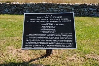
(Main Tablet): C.S.A. D.R. Jones' Division, Longstreet's Command Brig. Gen. D.R. Jones, Commanding. September 17, 1862. About 7.30 a.m., Col. Geo. T. Anderson's Brigade moved from Cemetery Hill to the left near the Dunker Church. The . . . Map (db m6575) HM
10 Maryland, Washington County, Sharpsburg — 377 — Wise (Virginia) Artillery
On Branch Avenue, on the right when traveling south.
C.S.A. Wise (Virginia) Artillery. Capt. J.S. Brown, Commanding. The Wise Artillery was the only one of the four batteries attached to D.R. Jones' Division which was present on the field. During the greater part of the engagement it occupied the . . . Map (db m6606) HM
11 Maryland, Washington County, Sharpsburg — 347 — Longstreet's CommandDrayton's Brigade, Jones' Division
On Branch Avenue, on the right when traveling south.
C.S.A. Longstreet's Command, Drayton's Brigade, Jones' Division Brig. Gen. Thomas F. Drayton, Commanding. Organization. 50th Georgia Infantry, 51st Georgia Infantry, 15th South Carolina Infantry, (September 15-17, 1862.) Drayton's Brigade . . . Map (db m6597) HM
12 Maryland, Washington County, Sharpsburg — 346 — Longstreet's CommandKemper's Brigade, D.R. Jones' Division
On Branch Avenue, on the right when traveling south.
C.S.A. Longstreet's Command. Kemper's Brigade, D.R. Jones' Division, Brig. Gen. James L. Kemper, Commanding. Organization. 1st, 7th, 11th, 17th and 24th Virginia Infantry. (September 15-17, 1862.) Kemper's Brigade reached Sharpsburg about noon . . . Map (db m6602) HM
13 Maryland, Washington County, Sharpsburg — 345 — Longstreet's CommandToombs' Brigade, D.R. Jones' Division
On Harpers Ferry Road, on the right when traveling north.
C.S.A. Longstreet's Command. Toombs' Brigade, D.R. Jones' Division Brigadier General Robert Toombs, Commanding. Organization. 2d, 15th, 17th, and 20th Georgia Infantry. (September 15-17, 1862.) Toombs' Brigade took position on the evening of . . . Map (db m6766) HM
14 Maryland, Washington County, Sharpsburg — K — Kemper's (Va) Brigade
On Harpers Ferry Road, on the right when traveling north.
C.S.A. From noon, September 15, 1862, until driven from position late in the afternoon of the 17th, the right of the infantry line of the Army of Northern Virginia, held by Kemper's Virginia Brigade, was 265 yards due east of this point. Toombs' . . . Map (db m6771) HM
 
 
CeraNet Cloud Computing sponsors the Historical Marker Database.
This website earns income from purchases you make after using our links to Amazon.com. We appreciate your support.
Paid Advertisement
May. 21, 2024