14 entries match your criteria.
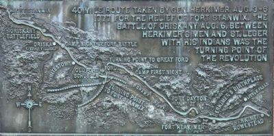
General Herkimer's 40 Mile March Historical Markers Each historical monument is part of a series of 14 historical monuments that mark the 40 mile route taken by Gen. Herkimer Aug. 3-6, 1777 for the relief of Fort Stanwix, that results in the Battle of Oriskany.
By Dale K. Benington, July 29, 2011
General Herkimer Takes Command Marker
GEOGRAPHIC SORT Title Sort Marker Number Sort Marker Number Sort N Marker Number Sort T Publication Order Sort Publication Order Sort A Erected Year Sort Most Viewed Sort Most Recent-Interest Sort Most Recently Changed Sort SEE FAQ #33 FOR DESCRIPTIONS
On North Main Street at Court Street, on the left when traveling south on North Main Street.
Near State Route 169 (New York State Route 169) east of General Herkimer Road.
Near State Route 169 (New York State Route 169) east of General Herkimer Road.
On New York State Route 5S west of Plantation Road, on the left when traveling east.
On New York State Route 5S west of Plantation Road (County Route 212A), on the left when traveling east.
On New York State Route 5 west of Windfall Road, on the right when traveling west.
On Utica Street near River Street.
On Rome Oriskany Road (New York State Route 69) 0.4 miles east of Monument Road, on the left when traveling east.
On Herkimer Road at Leland Avenue, on the left when traveling east on Herkimer Road.
On Whitesboro Street east of Burchard Lane, on the left when traveling east.
On Whitesboro Street east of Erie Street, on the right when traveling west.
On Main Street west of Railroad Street, on the right when traveling west.
On Main Street west of Railroad Street, on the right when traveling west.
On Main Street west of Victory Parkway, on the right when traveling west.
May. 8, 2024