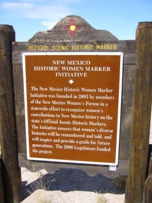
New Mexico Women’s Historic Marker Initiative Historical Markers
The New Mexico Women’s Historic Marker Initiative markers series consists of close to 100 markers that now grace the highways and small towns in the state. See https://www.nmhistoricwomen.org for the complete list.
On Tramway Road NE (State Road 556 at milepost 5.6), 0.5 miles west of Federal Road 333, on the right when traveling east.
In 1912, State Librarian Lola Chávez de Armijo filed a gender discrimination law suit after the governor sought to replace her by court order, claiming that as a woman, she was unqualified to hold office under the constitution and laws of New . . . — — Map (db m45333) HM
On 10th Street SW at Atlantic Avenue SW, on the left when traveling south on 10th Street SW.
Dr. Gonzales was a pioneer in bilingual and bicultural education. She developed educational materials for students in New Mexico and Latin America and trained teachers in the curriculum. Born in Pecos, “Lola” taught in the area for . . . — — Map (db m45227) HM
On 19th Street NW north of Old Town Road NW, on the right when traveling south.
In February 1706 several families participated in the founding of Albuquerque but the names of only 22 are preserved in the historical record. Within those families were many women honored as being founders of La Villa San Felipe de . . . — — Map (db m45230) HM
On 1st Street SW at Gold Avenue SW, on the right when traveling north on 1st Street SW.
Harvey Girls
In 1883, the Fred Harvey Company hired women to serve in its diners and hotels along the Atchison, Topeka and Santa Fe Railway. Thousands of respectable, intelligent women were recruited from the Midwest and East Coast to come . . . — — Map (db m45326) HM
On Bridge Boulevard SE at Broadway Boulevard SE, on the right when traveling west on Bridge Boulevard SE.
Attorney, public servant, and activist, Graciela Olivárez was a high school dropout who became the first woman graduate of Notre Dame Law School where an award is presented each year in her name. She led national anti-poverty efforts and ensured . . . — — Map (db m45225) HM
On New Mexico Route 60, on the right when traveling west.
Ada McPherson Morley ran a ranch outside of Datil, New Mexico where she raised three children, including Agnes Morley Cleaveland. A crusader for women's rights, she opposed the infamous Santa Fe Ring, worked for women's suffrage for over thirty . . . — — Map (db m103064) HM
On U.S. 380 at milepost 165, on the right when traveling west.
One of the first female radio stars in the 1930s, Louise's career spanned from 1918-1950. Her recordings in English and Spanish sold millions of copies. Heading the Roswell-based group, Louise Massey and the Westerners, she became known . . . — — Map (db m73454) HM
On Interstate 40 at milepost 113.5, on the right when traveling east.
Educated at the Carlisle Indian School in Pennsylvania under the U.S. policy of acculturating Indian children through school and removal from their homelands, Susie was instrumental in bringing education back to Laguna. A lifelong teacher, oral . . . — — Map (db m36519) HM
On Ice Caves Road (New Mexico Route 53 at milepost 42.2), 0.8 miles east of Indian Service Route 125, on the right when traveling east.
Matilda Coxe Stevenson was the first female anthropologist to study the Native Americans of New Mexico. Her research focused on the religious practices of indigenous peoples, particularly of the Zuni, and on the lives of native women and children. . . . — — Map (db m163186) HM
Near Interstate 25 at milepost 434, on the right when traveling south.
Women of the Santa Fe Trail
The Women of the Santa Fe Trail endured untold hardships traveling across the Great Plains. In 1829, six Hispanic women were the first known female travelers going east on the trail. In 1832, Mary Donoho was . . . — — Map (db m107280) HM
On U.S. 60 at milepost 366, on the right when traveling west.
This is a two sided markerSide A:
Estella García
Estella García taught colcha embroidery at Melrose, New Mexico, for the Federal Arts Program in the 1930s. Anglo and Hispana women in Garcia's class collaborated to . . . — — Map (db m73703) HM
On Espina Street at Espina Street and Horseshoe Street, on the right when traveling south on Espina Street.
Punished for not speaking English in school, María Gutiérrez Spencer devoted her life to validating the Indo-Hispano experience. A graduate of University of California, Berkeley and New Mexico State University, she pioneered bilingual and bicultural . . . — — Map (db m89687) HM
On State Road 152 at milepost 2.3,, 2.3 miles east of U.S. 180, on the right when traveling east.
After eight failed negotiating sessions and the expiration of their labor contract, Mexican-American workers at nearby Empire Zinc mine struck for wage and benefit equality. When an injunction prohibited union members from picketing, the women - . . . — — Map (db m38229) HM
On East Broadway at North Hudson Street, on the right when traveling west on East Broadway.
This is a two-sided marker
Front Side:
Anita Scott Coleman’s mother was a slave and her father a Buffalo Soldier. Raised on a ranch near Silver City, her award-winning essays, stories, and poems emphasized racial pride and black women’s . . . — — Map (db m121818) HM
On U.S. 84 at milepost 77.5,, 0.4 miles south of State Road 119, on the left when traveling south.
Side A:
At four, Manuelita de Atocha (Mela) Lucero Leger read Spanish language newspapers to her blind grandfather in Colonias. Although New Mexico's constitution protects Spanish-speaking students, school children were often punished . . . — — Map (db m45893) HM
(Front): Emma Marble Muir (1873–1959)
Rita Wells Hill (1901–1985)
Janaloo Hill Hough (1939–2005)
Emma Marble Muir arrived at the mining town of Shakespeare in 1882. She and her daughter, Rita Wells Muir, learned . . . — — Map (db m38246) HM
On U.S. 380 at milepost 231, on the right when traveling west.
This is a two sided markerFront of Marker
Dessie Sawyer was a rancher, philanthropist and political activist. Her work with community and charitable organizations advanced her into politics. She became the National Committee Woman . . . — — Map (db m73466) HM
Near U.S. 180 at milepost 144.7, on the right when traveling south.
This is a two-sided markerFront Side:
Immortalized in literature and film, Kentucky native Carlotta Thurmond was the inspiration for Miss Kitty on television’s “Gunsmoke.” Having toured Europe’s best gambling houses as . . . — — Map (db m121902) HM
On State Road 26 at milepost 10.2, on the right when traveling east.
Born into slavery, Cathay was liberated in 1861 and worked as a cook for the Union army during the Civil War. In 1866 she enlisted in the U.S. Army as Private William Cathey serving with the Buffalo Soldiers at Fort Cummings and Fort Bayard until . . . — — Map (db m38211) HM
On East Pine Street, on the right when traveling east.
This is a two-sided markerFront Side:
Born in 1827, Mary Ann Deming was married to Charles Crocker, one of the founders of the Central Pacific Railroad. A “silver spike” was driven here in 1881 that commemorated . . . — — Map (db m121958) HM
On State Road 518 just north of State Road 434, on the right when traveling north.
In New Mexico, women blessed with special knowledge of herbs, household remedies, human health and strong faith are trusted to cure real or imaged maladies. Known as Curanderas, these women have been an integral part of the Hispanic fabric in . . . — — Map (db m73273) HM
On U.S. 70 at milepost 256.2, on the right when traveling east.
Lozen, a warrior and sister of the famous Warm Springs Apache chief Victorio, fought alongside her brother until his death in 1880 and later with his successors, Nana and Geronimo. Lozen also was a medicine woman and healer and, it was said, . . . — — Map (db m46033) HM
On West Tucumcari Boulevard west of West Hines Avenue, on the right when traveling east.
Born in Bavaria and widowed in Las Vegas, New Mexico, Yetta ran the family store and raised four children alone. She later moved to La Cinta on the Canadian River where she opened another store, became postmistress, started a bank and operated a . . . — — Map (db m78891) HM
On Highway 84 (U.S. 84 at milepost 215.5) north of Abiquiu, on the right when traveling north.
One of America’s great and most celebrated painters of the twentieth century, Georgia O’Keeffe is known for her unique depictions of natural and architectural forms. She began spending summers painting in Northern New Mexico in 1929 and moved from . . . — — Map (db m73124) HM
On Highway 84 (U.S. 84) at State Road 233 on Highway 84.
Agueda is the matriarch of Hispanic weaving in New Mexico. From a very young age, she was known for her complex designs and natural dyes. She was the subject of the Academy Award-nominated documentary film, “Agueda Martinez: Our People, Our . . . — — Map (db m73393) HM
On State Road 68, 0.3 miles south of State Road 74, on the right when traveling north.
Esther Martinez served her community as an educator, linguist and storyteller. Her foremost contributions to our state are documenting and preserving the Tewa language and the art of storytelling. Esther was named a National Heritage Fellow in 2006 . . . — — Map (db m32856) HM
On Los Alamos Highway (State Road 30 at milepost 7.1) at Roller Road, on the left when traveling north on Los Alamos Highway.
Pablita Velarde was an internationally acclaimed artist whose paintings largely depicted Pueblo life. She was commissioned by the WPA art's program to paint murals at Bandelier National Monument. Selected as one of New Mexico's "Living Treasures", . . . — — Map (db m45663) HM
On U.S. 70, 1.7 miles east of State Road 202, on the right when traveling east.
Rose Powers White worked tirelessly to compile histories of early pioneers of southeastern New Mexico. She published numerous articles and was frequently asked to lecture to organizations and school groups. She served as president of the New . . . — — Map (db m56113) HM
On Browning Parkway at Burnham Road, on the right when traveling south on Browning Parkway.
Harriet was an astute financial manager and the first female bank president in New Mexico, operating the First National Bank in Farmington from 1922 until 1951. During the Depression she bought out San Juan National Bank, keeping it solvent and . . . — — Map (db m59629) HM
On Grand Avenue, on the right when traveling south.
Side A:
Meta L. Christy, DO, is recognized by the American Osteopathic Association as the first black osteopath. Dr. Christy graduated in 1921 from the Philadelphia College of Osteopathic Medicine as its first black graduate. The College . . . — — Map (db m45889) HM
On State Road 22, 0.2 miles west of Interstate 25, on the left when traveling west.
(side one)
According to oral and recorded history, the Santo Domingo people have always made and traded jewelry. From prehistoric times heishi, drilled and ground shell beads, have been strung into necklaces. Generations of Santo . . . — — Map (db m45475) HM
Women of Cochiti are known for reviving the historic figurative tradition now referred to as Storytellers, adult clay figurines surrounded by children. The efforts of these women have bloomed into a vibrant cottage industry, inspiring many potters . . . — — Map (db m73262) HM
On State Road 4, on the right when traveling east.
Jemez Pueblo. Evelyn M. Vigil, a descendant of the last remaining Pecos residents that moved to Jemez Pueblo in 1838, led a revival of Pecos Pueblo style pottery. She spent time at Pecos National Historic Park studying materials and techniques . . . — — Map (db m73244) HM
On State Road 165 at milepost 0.2,, 0.2 miles east of Interstate 25, on the right when traveling east.
(side one)
New Mexico has a proud history of military service. We are a state of culturally diverse citizens who are willing to defend our freedom and rights. Over 15,000 women in New Mexico have volunteered to serve in our military. These . . . — — Map (db m45458) HM
On Corrales Road (State Road 448) at Gray Hawk Drive, on the right when traveling south on Corrales Road.
(front)
Teacher, agriculturalist, farmer and conservationist, Dulcelina Curtis led efforts to control flooding of arroyos in Corrales where a flood-control channel is named in her honor. The first woman appointed to a board of the U.S. . . . — — Map (db m45438) HM
On State Road 503, 3.2 miles east of U.S. 84, on the right when traveling west.
The St. Francis Women's Club was instrumental in raising funds to rebuild San Francisco de Asís Church, which had been condemned and demolished in about 1960.
Their main fundraiser was the annual Fourth of July Ceremonial, featuring dances of . . . — — Map (db m32833) HM
On Cities of Gold Road - frontage (U.S. 84) 0.2 miles north of Viarrial Road (U.S. 285), on the right.
Feliciana Tapia Viarrial helped establish today's
Pueblo of Pojoaque. Pojoaque, or Posuwageh, water
drinking place, is a Tewa village founded circa A.D.
900. By 1919, the Pojoaque homelands were severely
diminished. Most members left . . . — — Map (db m32835) HM
On State Road 502 at milepost 12.5 at Povi Kaa Drive (Road 401), on the right when traveling west on State Road 502.
Maria Martinez was a self-taught potter who helped elevate Pueblo pottery to a respected art form. She and her husband Julian were successful polychrome potters and together revived black pottery. Their work improved the economic conditions of the . . . — — Map (db m45657) HM
Near Interstate 25 at milepost 269,, 1.5 miles west of Waldo Canyon Road (County Road 57).
(side one)
Amelia Elizabeth White (1878-1972)
Amelia Elizabeth White worked tirelessly to promote Indian art and to preserve Santa Fe's heritage. A philanthropist and community activist, she donated land for the Laboratory of . . . — — Map (db m45484) HM
On Veterans Memorial Highway (New Mexico Route 599) north of Airport Road (New Mexico Route 284), on the right when traveling north.
Katherine was the fourth American woman to earn a pilot's license and the first female skywriter. She overcame pioneering aviator Max Lillie's reluctance to teach her to fly, and became the "Flying Schoolgirl," nicknamed for her youthful looks, . . . — — Map (db m185053) HM
Near Interstate 25, 1.5 miles west of Waldo Canyon Road (County Road 57).
(side one)
An outstanding photographer of the twentieth century, Laura Gilpin is best known for capturing southwestern cultures and landscapes on film. When her car ran out of gas on the Navajo reservation in 1930, she began . . . — — Map (db m45483) HM
Near Interstate 25 at milepost 269,, 1.5 miles west of Waldo Canyon Road (County Road 57).
(side one)
Maria Gertrudis Barceló or Doña Tules, a notorious gambler and courtesan, operated a gambling house and saloon on Burro Alley in Santa Fe. She traveled up El Camino Real from Sonora, Mexico in 1815. Bishop Jean-Baptiste Lamy . . . — — Map (db m45479) HM
On East Alameda Street at Old Santa Fe Trail, on the left when traveling west on East Alameda Street.
(side one)
Four Sisters of Loretto, Mother Magdalen Hayden and Sisters Roberta Brown, Rosana Dant and Catherine Mahoney, arrived in Santa Fe from Kentucky on September 26, 1852. In January 1853 they established Our Lady of Light Academy, . . . — — Map (db m119764) HM
Near Interstate 25 at milepost 269,, 1.5 miles west of Waldo Canyon Road (County Road 57).
(side one)
The first Sisters of Charity arrived in New Mexico Territory in 1865 from Cincinnati at the request of Bishop Lamy with the mission of serving all people regardless of race, religion or ability to pay. Hundreds of sisters . . . — — Map (db m45482) HM
Near Interstate 25 at milepost 269,, 1.5 miles west of Waldo Canyon Road (County Road 57).
(side one)
Three generations of one family worked more than 100 years to preserve the cultural heritage of New Mexico. Eva Fenyes created an artistic and photographic record of missions and adobe buildings, and preserved Spanish . . . — — Map (db m45481) HM
On North Date Street at North Main Street, on the left when traveling north on North Date Street.
(front)
Magnolia Ellis was a healer with a special gift. She opened a clinic in Hot Springs, today's Truth or Consequences. Patients claimed to have a feeling of electricity when she touched them. Recognized by most notable doctors of the . . . — — Map (db m45109) HM
On Interstate 25, on the right when traveling south.
Traveling with the colonizing expedition of Juan de Oñate, Doña Eufemia rallied Spanish soldiers to persevere when morale broke down during their long journey on the Camino Real. Settling in present-day New Mexico, she rallied 22 women to defend the . . . — — Map (db m100056) HM
On Interstate 25 at milepost 114, on the right when traveling north.
Front of Marker
In 1598 the first Spanish settlers in New Mexico traveled up the Camino Real from north-central Mexico. Of the 560 people so far identified on that expedition, at least 20 percent were women. They came on foot, on wagons or . . . — — Map (db m45131) HM
On State Road 75 at BIA 205 (Loop Road 205), on the left when traveling east on State Road 75.
Maria Ramita Simbola Martinez, Cora Durand, and Virginia Duran helped to preserve the distinctive micaceous pottery tradition that is important in Picuris and other nearby pueblos. Made with locally mined mica-rich clay, these unusual pots have a . . . — — Map (db m43808) HM
On State Road 68 at milepost 33.6,, 4.8 miles east of State Road 570, on the right when traveling north.
(side one)
Captive Women and Children of Taos County
In August 1760, around sixty women and children were taken captive in a Comanche raid on Ranchos de Taos. That raid is an example of the danger of living on New Mexico's . . . — — Map (db m45719) HM
On Main Street (New Mexico Route 325) at Gratz Street (New Mexico Route 456), on the right when traveling east on Main Street.
Front
Sarah "Sally" J. Rooke
(1843-1908)
Heroine of the Dry Cimarron Flood
On the night of August 27, 1908, while working as a telephone operator, Sally received a call that a wall of water was rushing down the Dry Cimarron . . . — — Map (db m104838) HM