On Saint John Street just east of Marina Street, on the left when traveling east.
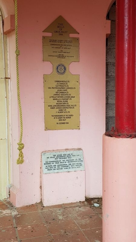
This stone was laid by his Grace Archbishop Kelvin Felix D.D. 16th December 1993, to commemorate the centenary of the blessing of these bells by Archbishop Flood. In faith and celebration this new belfry was built by the community with support . . . — — Map (db m116718) HM
C.O.’s Quarters 1782, rebuilt 1824
These quarters were never used by Admiral Rodney; he preferred to stay on his flagship “in comfort”.
Traces of a kitchen garden were found above to the left, behind the water tank, and two patios . . . — — Map (db m82716) HM WM
Carib Caves
The Caribbean Sea gets its name from the Calingo or Carib people from South America who began their migration northward into the Antilles about 1000 A.D. They settled in areas close to the mainland supplies of fresh water, flora and . . . — — Map (db m82697) HM
Cooperage
1778
In the late eighteenth and early nineteenth centuries British warships, transports and supply ships came and went in Gros Islet Bay and were refitted and resupplied at Pigeon Island. Barrels were the containers of the day. . . . — — Map (db m116717) HM
Fort Rodney 1778
Pigeon Island, only some 40 kilometres (25 miles) south of the French base at Fort Royal, Martinique, had long been recognized by the British Admiral Rodney as an important observation and defensive site. In 1780 he wrote . . . — — Map (db m82693) HM WM
Gunslide
Looking down the canyon you can see the deep bay where Admiral Rodney’s ships anchored during the years 1778-1782. The ships were able to lie at anchor in the deep water close to the island, and seamen where employed in hauling cannon . . . — — Map (db m82694) HM
Josset’s House 1969
This private house was destroyed in the hurricane of 1980 and by the action of the sea. By that time the owner, Josset Legh, had returned to England after a forty-year romance with her tropical island paradise.
In 1937 . . . — — Map (db m82696) HM
Lime Kiln
Eighteenth century
The most intensive period of British occupation on Pigeon Island was from 1779 to 1783. The lime kiln was one of the first structures built.
Lime was used as a binding agent for all masonry work. White lime was . . . — — Map (db m82695) HM WM
Musket Redoubt 1782
This outpost to Fort Rodney was built in 1782 to protect the ridge top from surprise attack from sea. The soldiers could be hidden in the sunken area and they could stand on the platform and look down on both sides of the . . . — — Map (db m82691) HM WM
1778, rebuilt 1824 Although the heyday of Pigeon Island as a British base in the Caribbean was in the late eighteenth century during the Rodney period, the garrison continued to be manned until 1861.
Built originally in 1778, this kitchen . . . — — Map (db m82875) HM
Officers’ Quarters and Mess 1824
Pigeon Island National Landmark Interpretation Centre 1993
The only existing structural elements from the original Officers’ Quarters and Mess, built in 1824, are the foundation walls and arches below the main . . . — — Map (db m82719) HM WM
Ridge Battery
The heaviest gun on Pigeon Island was sited here. It was a 32-pounder which could be turned from north to south to cover the St. Lucia Channel and Gros Islet Bay. The gun was used effectively in 1781 to repel the French invasion of . . . — — Map (db m82692) HM
Soldiers’ Barracks 1808, rebuilt 1824
The colonial struggle between Britain and France and her allies continued into the 1800s, although fighting was interrupted by short-lived treaties and peace settlements. British troops were still sent to . . . — — Map (db m188061) HM WM
Two-Gun Battery
In 1780 HMS Cornwall was damaged and Admiral Rodney requested that her deck timbers be used in construction of the two-gun battery on Pigeon Island.
This gun battery was to protect the island from a sea attack from the . . . — — Map (db m83231) HM WM
U.S. Signal Station 1941
Nearly two centuries after Rodney recognized its importance, Pigeon Island was again used as a strategic base, during World War II. This U.S. Signal Station was built over Rodney’s existing mortar battery dating from . . . — — Map (db m82690) HM WM