King and Queen County. Area 320 Square Miles. Formed in 1691 from New Kent, and named for King William III and Queen Mary. The family of George Rogers Clark long lived in this county.
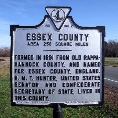
Essex County. Area 258 Square . . . — — Map (db m7492) HM
Near Water Street west of Buckner Street, on the right when traveling west.
Rugged men and women have made their living on the Chesapeake Bay and its rivers for centuries. Known as watermen, they hand down skills learned by observing water, climate, and wildlife. Consequently, younger generations learn time-honored . . . — — Map (db m64636) HM
On Moody Street west of N Bateman Road, on the left when traveling east.
Built 1860 by W.L. Moody, noted county merchant, for his bride, Elizabeth Bradley; sold after he moved to Galveston to his father-in-law, F.M. Bradley, one of this county's most influential men. Price was $2,800 in gold.
In Greek Revival style, . . . — — Map (db m272124) HM
On Cople Highway (Virginia Route 202) at Coles Point Road (County Route 612), on the right when traveling east on Cople Highway.
A mile and a half north, in the Lee burying ground, is the grave of Richard Henry Lee, who died, June 19, 1794. Lee was one of the first leaders of the American Revolution. On June 7, 1776, he introduced a resolution in the Continental Congress for . . . — — Map (db m22395) HM
On Cople Highway (Virginia Route 202) at Coles Point Road (County Route 612), on the right when traveling east on Cople Highway. Reported missing.
A mile and a half to the north is the Burnt House Field, a Lee family graveyard in which were buried Richard Lee of “Machotick,” Thomas Lee of “Stratford,” Richard Henry Lee of “Chantilly,” their wives, and others. These burials were in the garden . . . — — Map (db m275660) HM
On East Commerce Street (U.S. 84) at Oak Street, on the right when traveling east on East Commerce Street.
Came to Texas from Virginia, 1852. Organized and was captain of Co. G, 7th Texas Infantry, the first Freestone County unit to go into battle in the Civil War.
Captured at Fort Donelson, Tenn. Feb. 1862. Exchanged, soon won promotion to colonel . . . — — Map (db m271690) HM
Near Mill Street south of Greenville Avenue (Business U.S. 250).
Who was John Lewis? Lewis Creek takes its name from John Lewis (1678-1762), one of the most prominent of the earliest settlers in the upper Shenandoah Valley.
In the early 1730s, Lewis and his family, who emigrated from County Donegal, . . . — — Map (db m134484) HM
On Queen Street (U.S. 360) at Newbill Drive (County Route T-1013), on the right when traveling west on Queen Street.
British Raid on Tappahannock. On 2 Dec. 1814, British naval forces commanded by Capt. Robert Barrie shelled and seized the town of Tappahannock during the War of 1812. Aiding the British were three companies of African American Colonial . . . — — Map (db m97117) HM
On Tyler Street 0.1 miles east of White Street, on the right when traveling east.
Dentist, entrepreneur, developer, community leader, and advocate.
Dr. Harris's company, McGuire Inc., built more than 35 homes in Mayfield, a historically Black neighborhood in the city of Fredericksburg. Dr. Harris provided affordable . . . — — Map (db m242247) HM
On Bowery north of Broome Street, on the right when traveling north.
This is the former site of undertakers McGraw and Taylor, where the body of John Brown was secretly prepared for burial. Executed on December 2, 1859, for the raid on Harper’s Ferry, Virginia, the radical abolitionist had tried to ignite an armed . . . — — Map (db m179403) HM
On Tidewater Trail (U.S. 17) west of Forest Grove Road ( Route 718), on the right when traveling east.
Thomas Washington, an African American man, was lynched on 23 March 1896 for allegedly attempting to assault the young daughter of a prominent white citizen. A boy found Washington’s body hanging from a tree about 1/8 mile southwest of here. A . . . — — Map (db m191126) HM
On Brooke Road 0.1 miles west of Chandlee Mill Road, on the right when traveling west.
Lineage of Leatha Howard Holland Webster and the Canadian Connection
The Howard-Holland traces its roots to the Montgomery County plantations of the Gaithers, Howse and Griffith families. From census records and manumission . . . — — Map (db m188339) HM
On Cople Highway (Virginia Route 202) just west of the Hampton Hall Bridge over Hampton Hall Branch, on the right when traveling east.
Northumberland County. Area 205 square miles. Originally an Indian district called Chicacoan. In 1648 it became Northumberland County, named for an English county. The mouth of the Potomac River is here.
Westmoreland . . . — — Map (db m22471) HM
On Rockhouse Road, on the right when traveling north.
Born in Essex County Virginia 1756.
Died at The Rock House April 5, 1822.
Soldier, officer and patriot of the
Revolution who volunteered to fight
for the independence of his country.
Member of the House of Commons and
for many years . . . — — Map (db m210497) HM
On Tidewater Trail (U.S. 17) north of Ashdale Road, on the right when traveling north.
Just to the East stood Mann Meeting House, the first Methodist Episcopal Church in this region. It was built before 1794 and abandoned about 1880. The site is now occupied by the Macedonia Colored Baptist Church. — — Map (db m3080) HM
On Old Virginia Street (County Route 602) west of Upton Lane, on the right when traveling west.
In 1763 Ralph Wormeley III of Rosegill sold this house to James Mills, a Scottish merchant. In 1791 Arthur Lee bought it and 1,000 adjacent acres to be his home in retirement. Lee named this estate Landsdowne in honor of his friend, William . . . — — Map (db m316385) HM
Thin black lines indicate changes in relevance. Between each pair of lines entries are ordered geographically but all have the same relevance.
* Inflectional forms of words are their plurals, singulars, and possessives as well as gramatical tenses and similar variations.