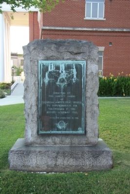
On Tomlinson Avenue at 7th Street, on the left when traveling north on Tomlinson Avenue.
Erected by
The County Court
of
Marshall County West Virginia
to commemorate its
volunteers in the
Spanish-American War
They served that others might be free — — Map (db m55011) WM
On West Virginia Route 2 2.4 miles south of Interstate 470, on the right when traveling south.
Marshall County. Formed in 1835 from Ohio. Named for Chief Justice John Marshall. In Marshall County is Grave Creek Mound, first among remains left by the unknown race which lived in the Ohio Valley centuries before the white man came. . . . — — Map (db m57250) HM
On Wheeling Avenue, on the right when traveling south.
The Cockayne Farm
The Cockayne farmhouse was built by Bennett Cockayne around 1850. His son Samuel A.J. was renowned as a sheep breeder. Dubbed Glendale by Samuel's wife Hannah, the farm was the namesake for Glen Dale when it was . . . — — Map (db m102040) HM
Near Jefferson Avenue (U.S. 250) at Cemetery Road, on the right when traveling north.
This humble stone is erected to the memory of Captain Foreman and twenty-one of his men who were slain by a band of ruthless savages, the allies of a civilized nation of Europe on the 26th of Sep, 1777.
So sleep the brave who sink to rest by . . . — — Map (db m296979) HM
On U.S. 250 0.3 miles south of Pogue Run Road, on the right when traveling south.
Marion County
Formed, 1842, from Harrison and Monongalia. Named for hero of the Revolution, Gen. Francis Marion. County was home of Francis H. Pierpont, leader in formation of this State. The Monongahela River forms just above Fairmont.
. . . — — Map (db m71114) HM
On Rock Lick Road (West Virginia Route 891) 0.2 miles west of Dodds Ridge Road ( Route PA 4001), on the right when traveling west. Reported missing.
West Virginia (Marshall County)
"The Mountain State" - western part of the Commonwealth of Virginia until June 20, 1863. Settled by the Germans and Scotch-Irish. It became a line of defense between the English and French during the French . . . — — Map (db m296435) HM
On 7th Street east of Lafayette Avenue ( Route 2), on the right when traveling east.
Rescued the body of 2nd Lieutenant Benjamin H. Hodgson from within the enemy lines; brought up ammunition and encouraged the men in the most exposed positions under heavy fire in the Little Big Horn River fight.
Sergeant Benjamin C. Criswell . . . — — Map (db m20503) HM
On Mason Dixon Highway (West Virginia Route 7) 1.5 miles east of Hornet Highway (U.S. 250), on the right when traveling west. Reported missing.
Monongalia County
Formed, 1776, from District of West Augusta. All or parts of 21 other counties, including three in Pennsylvania, were carved from it. Named for the Monongahela River, bearing an Indian name, which means the "River of . . . — — Map (db m296475) HM
On Wheeling Avenue (U.S. 250) 0.1 miles north of 13th Street, on the left when traveling north.
The Cockayne Mound is one of the few remaining intact prehistoric mounds in Marshall County. It has been given site number 46MR26 in the archaeological files of the West Virginia Division of Culture & History.
In January, 2005, Jamie Vosvick . . . — — Map (db m164734) HM
On Dragon Highway (U.S. 250) 0.2 miles south of Georgetown Road, on the right when traveling south. Reported missing.
Marshall County
Formed, 1835, from Ohio and named for Chief Justice John Marshall. In Marshall County is Grave Creek Mound, first among remains left by the unknown race which lived in the Ohio Valley centuries before the white man came.
. . . — — Map (db m296436) HM
On West Virginia Route 2 0.7 miles north of Route 89, on the right when traveling south.
Side A
Marshall County
Formed, 1835, from Ohio and named for Chief Justice John Marshall. In Marshall County is Grave Creek Mound, first among remains left by the unknown race which lived in the Ohio Valley centuries before the white . . . — — Map (db m80249) HM
On 7th Street at Tomlinson Avenue, on the right when traveling west on 7th Street.
This monument honors, recognizes, and serves Gold Star Families and the legacy of their Loved Ones who have paid the ultimate sacrifice while serving in the Armed Forces of the United States of America.
The Homeland panel depicts images . . . — — Map (db m315577) WM
On Tomlinson Avenue at 7th Street, on the left when traveling north on Tomlinson Avenue.
Erected By
The County Court
of Marshall County,
West Virginia
To Commemorate the Service
Men and Women of Marshall
County in the World War
1917 - 1919
The tumult and the shouting dies-
Lord God of Hosts - Be with us yet . . . — — Map (db m54933) WM
On Buckeye Road (County Route 29) north of Mason-Dixon Highway ( Route 7), on the left when traveling north. Reported missing.
Branch of Warrior Trail of the Great Catawba Indian War Path located here where Mason and Dixon Survey crossed Dunkard Creek for third time. Guide, Six Nations Indians’ chief, declared he “would not proceed one step further,” because hostile . . . — — Map (db m175212) HM
Thin black lines indicate changes in relevance. Between each pair of lines entries are ordered geographically but all have the same relevance.
* Inflectional forms of words are their plurals, singulars, and possessives as well as gramatical tenses and similar variations.