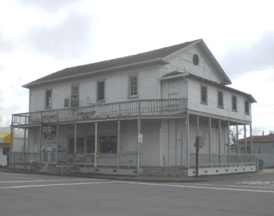
Built in 1881, the building was bought by the newly instituted Lodge on July 11, 1882. The upstairs has served continuously as a meeting hall since then.
Dedicated on October 8, 1994 Tuleburgh Chapter #69, E Clampus Vitus — — Map (db m241688) HM
Pioneer Hill
It was on this hill that Dr. Dean Jewett Locke and his brother Elmer H. Locke built the first cabin of this section in 1851. Disturbed by grizzly bears, they spent their first nights in the oak trees. Dr. Locke, physician for the . . . — — Map (db m143490) HM
On this site the Boston-Newton Joint Stock Association encamped on September 26, 1849. The company left Boston April 16 and arrived at Sutter’s Fort September 27. After a remarkable journey across the continent a rich store of written records . . . — — Map (db m11568) HM
Built through subscription by the residents of Woodbridge and dedicated as Woodbridge Seminary in 1879 by the United Brethren Church, this was the site of San Joaquin Valley College from 1882 to 1897. It was then used as Woods Grammar School until . . . — — Map (db m15990) HM
On this site is the former homestead of the founder of Oceanside, Andrew Jackson (A.J.) Myers. A native of La Salle County Illinois, A. J. Myers was born in 1840, and lived for a time in San Joaquin County, California in 1852. He served in the . . . — — Map (db m54231) HM
This river town was established in 1849. Pioneers and
freight wagons following post roads to the southern
mines crossed the river nearby at Durham's Ferry. As a
terminal for riverboats, the town played an important
part in development of west . . . — — Map (db m146456) HM
Charles M. Weber | 1849
The site of the first courthouse building in San Joaquin County was donated by Captain Charles M. Weber, a German immigrant and founder of Stockton.
Captain Weber acquired over 48,000 acres through a Mexican land . . . — — Map (db m221058) HM
He is ranked among the representative citizens of Los Angeles County. He left Missouri in 1849 and settled in Santa Clara County. He came to Southern California in 1869 and purchased 325 acres of the old Dalton Tract, near El Monte. His family . . . — — Map (db m152637) HM
Approximately six miles west, 20 Mormon pioneers from ship Brooklyn founded first known agricultural colony in San Joaquin Valley. Planting first wheat; also crops they irrigated by the pole and bucket method. Erected three log houses, operated . . . — — Map (db m143447) HM
Old Liberty was a stagecoach stop in the north east section of San Joaquin County. It linked lower Sacramento to the gold country. As the weary pioneers would pass through Liberty they buried their loved ones here and several of them were children . . . — — Map (db m141106) HM
First and oldest Protestant house in northern San Joaquin County. Built in 1859 on land donated by Donald J. Staples. Constructed of bricks given by Dr. D.J. Locke, founder of Lockeford and Mr. James Tallmadge, a builder and brick mason. Built by . . . — — Map (db m41406) HM
First known sail launch to ascend San Joaquin River from San Francisco landed here autumn 1846. Carried 20 Mormon pioneers who founded New Hope agricultural project on the Stanislaus. Yoke of oxen and span of mules driven from Marsh’s Landing . . . — — Map (db m143445) HM
A dedication plaque for a historical building
by the Native Sons of the Golden West,
Stockton Parlor No. 7
Casa Bonita Funeral Home
Formerly known as the Casa Bonita Mausoleum. Established in Stockton, California the year of 1928. The . . . — — Map (db m221745) HM
Thin black lines indicate changes in relevance. Between each pair of lines entries are ordered geographically but all have the same relevance.
* Inflectional forms of words are their plurals, singulars, and possessives as well as gramatical tenses and similar variations.