General Herkimer's 40 Mile March Historical Markers
Each historical monument is part of a series of 14 historical monuments that mark the 40 mile route taken by Gen. Herkimer Aug. 3-6, 1777 for the relief of Fort Stanwix, that results in the Battle of Oriskany.
On North Main Street at Court Street, on the left when traveling south on North Main Street.
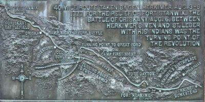
40 mile route taken by Gen. Herkimer Aug. 3-6, 1777 for the relief of Fort Stanwix. The Battle of Oriskany Aug. 6, between Herkimer's men and St. Leger with his Indians was the turning point of the Revolution.
At Fort Dayton, near this . . . — — Map (db m54261) HM
Near State Route 169 (New York State Route 169) east of General Herkimer Road.
40 mile route taken by Gen. Herkimer Aug. 3-6, 1777 for the relief of Fort Stanwix. The Battle of Oriskany Aug. 6, between Herkimer's men and St. Leger with his Indians was the turning point of the Revolution.
From this point
General . . . — — Map (db m75330) HM WM
Near State Route 169 (New York State Route 169) east of General Herkimer Road.
40 mile route taken by Gen. Herkimer Aug. 3-6, 1777 for the relief of Fort Stanwix. The Battle of Oriskany Aug. 6, between Herkimer's men and St. Leger with his Indians was the turning point of the Revolution.
To the memory of the men . . . — — Map (db m57308) HM
On New York State Route 5S west of Plantation Road, on the left when traveling east.
40 mile route taken by Gen. Herkimer Aug. 3-6, 1777 for the relief of Fort Stanwix. The Battle of Oriskany Aug. 6, between Herkimer's men and St. Leger with his Indians was the turning point of the Revolution.
Here was born Nicholas . . . — — Map (db m57358) HM
On New York State Route 5S west of Plantation Road (County Route 212A), on the left when traveling east.
40 mile route taken by Gen. Herkimer Aug. 3-6, 1777 for the relief of Fort Stanwix. The Battle of Oriskany Aug. 6, between Herkimer's men and St. Leger with his Indians was the turning point of the Revolution.
Near this spot was the site . . . — — Map (db m57353) HM
On New York State Route 5 west of Windfall Road, on the right when traveling west.
40 mile route taken by Gen. Herkimer Aug. 3-6, 1777 for the relief of Fort Stanwix. The Battle of Oriskany Aug. 6, between Herkimer's men and St. Leger with his Indians was the turning point of the Revolution.
General Herkimer
camped near . . . — — Map (db m54257) HM
40 mile route taken by Gen. Herkimer Aug. 3-6, 1777 for the relief of Fort Stanwix. The Battle of Oriskany Aug. 6, between Herkimer's men and St. Leger with his Indians was the turning point of the Revolution.
Near this spot
on the night . . . — — Map (db m65974) HM
On Rome Oriskany Road (New York State Route 69) 0.4 miles east of Monument Road, on the left when traveling east.
40 mile route taken by Gen. Herkimer Aug. 3-6, 1777 for the relief of Fort Stanwix. The Battle of Oriskany Aug. 6, between Herkimer's men and St. Leger with his Indians was the turning point of the Revolution.
Near this spot
Stood the . . . — — Map (db m32062) HM
On Herkimer Road at Leland Avenue, on the left when traveling east on Herkimer Road.
40 mile route taken by Gen. Herkimer Aug. 3-6, 1777 for the relief of Fort Stanwix. The Battle of Oriskany Aug. 6, between Herkimer's men and St. Leger with his Indians was the turning point of the Revolution.
At this point,
On August 5, . . . — — Map (db m32452) HM
On Whitesboro Street east of Burchard Lane, on the left when traveling east.
40 mile route taken by Gen. Herkimer Aug. 3-6, 1777 for the relief of Fort Stanwix. The Battle of Oriskany Aug. 6, between Herkimer's men and St. Leger with his Indians was the turning point of the Revolution.
General Herkimer . . . — — Map (db m242485) HM
On Whitesboro Street east of Erie Street, on the right when traveling west.
40 mile route taken by Gen. Herkimer Aug. 3-6, 1777 for the relief of Fort Stanwix. The Battle of Oriskany Aug. 6, between Herkimer's men and St. Leger with his Indians was the turning point of the Revolution.
On August 5, 1777
leading . . . — — Map (db m32430) HM
On Main Street west of Railroad Street, on the right when traveling west.
40 mile route taken by Gen. Herkimer Aug. 3-6, 1777 for the relief of Fort Stanwix. The Battle of Oriskany Aug. 6, between Herkimer's men and St. Leger with his Indians was the turning point of the Revolution.
1500 feet east of this spot . . . — — Map (db m54245) HM
On Main Street west of Railroad Street, on the right when traveling west.
40 mile route taken by Gen. Herkimer Aug. 3-6, 1777 for the relief of Fort Stanwix. The Battle of Oriskany Aug. 6, between Herkimer's men and St. Leger with his Indians was the turning point of the Revolution.
The site of Old Fort . . . — — Map (db m54256) HM
On Main Street west of Victory Parkway, on the right when traveling west.
40 mile route taken by Gen. Herkimer Aug. 3-6, 1777 for the relief of Fort Stanwix. The Battle of Oriskany Aug. 6, between Herkimer's men and St. Leger with his Indians was the turning point of the Revolution.
The rear guard of
General . . . — — Map (db m32442) HM