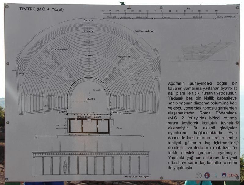
Text on German Side of Marker:
Das Theater von Assos wurde im 4. Jh.
v. Chr. südlich unterhalb der Agora in
einen natürlichen Hang hineingebaut. Mit
seiner Hufeisenform stellt es ein typisch
griechisches Bauwerk dar. Es . . . — — Map (db m119882) HM
English Text:
View of the outside of the Troia II/III Citadel Wall, ca 2500-2200 BCE.
(Schliemann's 'Burnt City').
This reconstruction built with hand made and fired mudbrick preserves the original mudbrick material, which is . . . — — Map (db m123278) HM
English Text:
You are now standing on the remains of the outer wall of the Greek and Roman temple precinct from the period of Troia VIII/IX (third century BCE - c. CE 500). In front of you lie the fortifications of Troia/Ilios. You . . . — — Map (db m123200) HM
English Text:
You are now standing on the remains of the foundations of an altar which belonged to the Greek and Roman temple of Athena (see Information-Sign 4). The remains of this temple had already been removed by stone-robbers . . . — — Map (db m123228) HM
English Text:
These large vat-like storage containers appear in the Mediterranean and Near East already in the Neolithic period along with the earliest pottery. They served primarily as a means to keep cool olive oil, wine, and grain, . . . — — Map (db m123122) HM
English Text:
Where you are now standing there once lay the forecourt of the temple of Athena belonging to the Greek and Roman city Ilion. Looking down you can see in the center of the mound a wide area at a lower level. This was . . . — — Map (db m123252) HM
English: The 57th Infantry Regiment was formed during the Balkan War in 1912. On 1 February 1915, it was reconstituted under the command of the 19th Infantry Division as part of the Turkish Fifth Army.
The regiment showed outstanding . . . — — Map (db m85113) HM
These ten panels, mounted upon a wall facing the sea, describes the conflict between Allied and Turkish forces on the Gallipoli Peninsula in 1915.
Panel #1
English:
The Dardanelles
A good army of . . . — — Map (db m85295) HM WM
English:
This beach, 600 metres long by 20 metres wide was the life line to the Allied soldiers within the Anzac perimeter. Because of Turkish shellfire, supplies could only be landed at night and carried by men and mules along tortuous . . . — — Map (db m85219) HM
English:
By early l9l5, the Western Front in France and Flanders had reached a stalemate. The British War Council sanctioned a plan to attack the Ottoman Empire, which was fighting alongside the Central Powers, led by Germany. By . . . — — Map (db m85184) HM WM
English:
At 0430 hours on 25 April, 36 rowing boats landed the first Australian soldiers around this point and at Anzac Cove. Immediately they climbed the 100 metre hill behind you (Plugge's Plateau) and by 1000 hrs. secured a front line . . . — — Map (db m85183) HM
"Those heroes that shed their blood and lost their lives... you are now living in the soil of a friendly country. Therefore rest in peace. There is no difference between the Johnnies and the Mehmets to us where they lie side by side here in this . . . — — Map (db m85220) WM
English:
During the Gallipoli campaign, this area was known as 'Hell Spit'. To the north is the beach which became known as Anzac Cove, where some 27,000 Australian and New Zealand, British and Indian troops came ashore between 25 April . . . — — Map (db m85241) HM
English:
New Zealand and British Forces climbed from the beach under cover of darkness and launched a surprise attack on this hilltop, capturing it on 8 August 1915. They held the area immediately around the New Zealand Memorial for 2 . . . — — Map (db m85151) HM
To the glory of God and the lasting memory of 3268 Australian soldiers who fought on Gallipoli in 1915 and have no known graves, and 456 New Zealand soldiers whose names are not recorded in any other areas of the peninsula but who fell in the Anzac . . . — — Map (db m85110) WM
Turkish:
"Biz Çanakkale Yarımadasının Türklerle savaşarak ve binlerce insanımızı kaybederek kahraman Turk milletine ve onun essiz vatan sevgisine duyduǧumuz büyük takdir ve hayranlıkla . . . — — Map (db m85248) WM
English:
The coast line curls eastwards passing Ariburnu and turns North running about 160 meters along up to Nibrunesi Point (Kuchulx Kemekli). The Anzacs called the coast line here “North Beach" because of its perspective viewing . . . — — Map (db m85281) HM
English: The Allied objectives in the Gallipoli Campaign were, by capturing Istanbul, to force Turkey out of the war, to secure an ice-free sea supply route to Russia and to open another front against Germany and Austria-Hungary. The . . . — — Map (db m85111) HM
English:
"On 10th of August 1915 the British Forces of 20,000 settled into their trenches where they had spent days digging and waiting for the moment to attack and occupy Chunuk Bair, and thereby dominate the Dardanelles. The darkness . . . — — Map (db m85148) HM
English:
This key position defended vigorously by both side saw repeated attacks across this narrow ridge. The ANZAC trenches were located close to the cemetery. The Turkish trenches originated near to the raised stone memorial on your . . . — — Map (db m85145) HM
English:
The Nek is a hillock, 157 m. above sea level, located at Russell's Top. It is a very important point which connects Russell's Top - which is 700 m. high and 40-100 m. wide and extending over Plugge's Plateau on the southwest - . . . — — Map (db m85147) HM WM
English:
This was a fiercely contested part of the front-line at Anzac. A narrow passage across the ridge known as ‘the Nek' lay just below a hill designated Baby 700 by Commonwealth forces. After the Armistice. the remains of several . . . — — Map (db m85115) HM WM