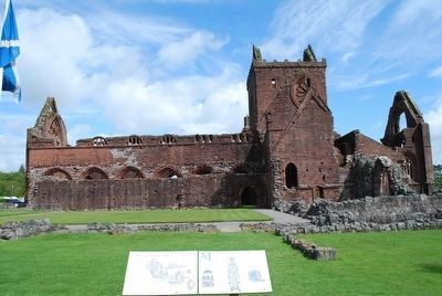
Sweetheart was established by Devorgilla, Lady of Galloway, in 1273, in memory of her husband John Balliol, father of King John of Scotland and founder of Balliol College, Oxford.
Monks of the Cistercian Order came from nearby Dundrennan . . . — — Map (db m91700) HM
On Royal Mile close to Old Assembly Close, on the right when traveling east.
The High Street Wellhead
The original wellhead or cistern in this position, probably of around 1675, had a chequered history. It was seriously damaged by a horse-drawn fire engine in January 1897 and rebuilt.
The cisterns provided water from . . . — — Map (db m127012) HM
The Antonine Wall was built by the Roman Emperor Antoninus Pius AD 142-143.
It ran for 37 miles from Bridgeness on the Forth to Old Kilpatrick on the Clyde and consisted of a ditch with a turf rampart behind it.
The material from the ditch . . . — — Map (db m86741) HM
THE LANDSCAPE
Around 10,000 years ago the landscape would have been fairly thickly covered with trees. Into this environment came our hunting and gathering ancestors around 8,000 years ago. These people would have cleared some of the trees . . . — — Map (db m86743) HM
The Antonine Wall was built by the Roman Army
on the orders of Emperor Antoninus Pius in the
140's AD. The Antonine Wall replaced Hadrian's
Wall as the far northern frontier of the Roman
Empire at this time, and ran for 40 Roman miles
(60km) . . . — — Map (db m86607) HM
The Antonine Wall was built by the Roman army in the 140's AD on the orders of the Emperor Antoninus Pius. For 20 years or more, the Wall was the north west frontier of the Roman Empire. It ran for 40 miles (64 km) from modern Bo'ness on the Forth . . . — — Map (db m86748) HM
From where you are standing, most of the defences of the Roman fort of Rough Castle are behind you. In front of you are the remains of a system of Roman pits which were re-excavated in 1903 and have since been kept open. These originally consisted . . . — — Map (db m86757) HM
Immediately in front you can see the Antonine Wall ditch, which forms the northern defences of the Roman fort. The drawing is a bird's-eye view of the site from this position, showing the Roman fort and annex as they would have appeared during . . . — — Map (db m86758) HM
On Scotland Route A838, 43.4 kilometers west of Scotland Route A836, on the left when traveling west.
Ceannabeinne
Ceann na Bienne
Ceannabeinne is the township at the end of a chain of hills stretching north from Cranstackie (801 m). The area divides Loch Eriboll from the Kyle of Durness. The pink coloured rock is Lewisian gneiss, commonly found . . . — — Map (db m127828) HM
On Scotland Route A838, 45.1 kilometers west of Scotland Route A836, on the right when traveling west.
Ceannabeinne Township Trail
The Highland Township
In the Eighteenth century Ceannabeinne was typical of a farming community in the Highlands. The farm was rented by a Tacksman from Lord Reay, Chief of Clan MacKay. In turn he sub-let the . . . — — Map (db m127829) HM
On Scotland Route A838, 45.1 kilometers west of Scotland Route A836, on the right when traveling west.
Ceannabeinne Township Trail
Houses and Homes – Life begins to get better
Of the 14 houses recorded here in 1841, little remains. However, in front of this sign you should be able to make out the rectangular foundation of a house, . . . — — Map (db m127830) HM
On Route A838 at Unnamed Road to Keoldale, on the right when traveling south on Route A838.
Keoldale Green
Rubha an Tigh Shaille
Rubha an Tigh Shaille is Gaelic for 'Point of the Salt House' more commonly known today as 'Keoldale Green. The land here is an oasis of green in a barren wilderness, the weathering of the ancient Cambrian . . . — — Map (db m127903) HM
On Quatre Bras (Scotland Route A99) at Village Road, on the left when traveling east on Quatre Bras.
To Commemorate
The Founder of this Village and Harbour
Lieutenant-General Patrick Sinclair
of Lybster
1735-1820
He served in North America 1759 -1784
with the Black Watch and the 15th
Regiment of Foot against the French and
Indians . . . — — Map (db m127540) HM WM
On Geat N Road (Scotland Route A862) at Black Isle Road, on the left when traveling south on Geat N Road.
Muir of Ord
"Am Blair Mhor" the Gaelic for Muir of Ord, means a ‘large clear level place' which is easy to be seen on the approach from Beauly. And it was this level space or Muir which was the site of the largest cattle fair in the north from 1820 . . . — — Map (db m127978) HM
On Route A99, 15.6 kilometers north of the Wick River, on the left when traveling north.
Brochs: Beacons of Belonging
You are standing in one of the most important archaeological landscapes in Britain. Scan the horizon. You are surrounded by history: old harbours, houses and burials. As you move around the coastline you will . . . — — Map (db m127566) HM
On Scotland Route A99, 3.2 kilometers south of of the village of John o' Groats, on the right when traveling south.
For 5000 years people have settled in the land stretching before you, leaving signs of their burials in the chamibered cairns found on the island of Stroma and on the summit of Warth Hill that rises behind this point. It takes its name from the . . . — — Map (db m127567) HM
On Scotland Route A96, 0.5 kilometers north of an unnamed road, on the left when traveling east.
The Pictish Rodney’s Stone was carved around 1,200 years ago.
A beacon for the community, it may have marked a place where people came to be baptised, married or hear Mass.
Brodie born and bred … The family home to over #400 varieties of . . . — — Map (db m128035) HM
Antonine Scotland
The Antonine period 140-c.165. Until c.139 AD Hadrian's Wall marked the limit of Roman occupied Britain; but when Antoninus Pius became Emperor he ordered the army to push further north and to build a second wall, this . . . — — Map (db m88540) HM
On Dundas Street at Khyber Pass, on the left when traveling south on Dundas Street.
Home of
Eliza Fraser
Who in 1836 survived shipwreck
on the Great Barrier Reef and
capture by Aborigines to
become a legendary
figure in Australian
history. — — Map (db m127651) HM