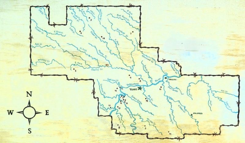
On Towne Avenue just south of Bowen Street, on the left when traveling south.
1. Historic grave site of Private George July 3, 1876 wounded in Custer battle 2. William Clark spent the night here July 30, 1806 3. Indian battle marker placed December 18, 1932; battle between Lt. Frank Baldwin, 110 men and 120 . . . — — Map (db m316300) HM
On Ten Mile Road just north of Park Street, on the left when traveling north.
In 1970, Congress enacted a Wilderness Act and designated 43,000 acres north of Terry in the badlands as a Wilderness Study Area. The Calypso Trail and Scenic View offer a grand look at the badlands area. Father DeSmet met with the Hunkpapa Sioux . . . — — Map (db m203104) HM
On Old Highway 10 near Powder River Road, on the right when traveling west.
Surrounding you is northern mixed-grass prairie stretching further than the eye can see in all directions. This is a place where exceptionally clean air mixes freely with the lilting serenades of sparrows and western meadowlarks. Where people and . . . — — Map (db m253719) HM
On Old Highway 10 near Powder River Road, on the right when traveling west.
The military paved the way for the settlement of the West-and the lands in front of you played a central role. The first military encampment here occurred on July 30, 1805, when Captain William Clark and other members of the Corps of Discovery . . . — — Map (db m253655) HM
Near Old Highway 10 near Powder River Road, on the right when traveling west.
Over the span of untold generations, rivers marked the primary travel routes used by nomadic tribes and the earliest explorers. The first steamboat to venture up the Yellowstone River to its confluence with the Powder River was the famed Far West, . . . — — Map (db m253720) HM
On West Old Highgway 19 at Milwaukee Road, on the right when traveling south on West Old Highgway 19.
Work on the 225 mile Eastern Mountain scion of the Milwaukee Railroad took place 1907-1908
The Milwaukee ran through a region of river and creek valleys making for the building of many bridges. The Yellowstone was crossed three times between . . . — — Map (db m282915) HM
On Old Highway 10, on the right when traveling west.
This is the river that exuberant parties claim is a mile wide, an inch deep, and runs up hill. The statement is exaggerated. Captain Clark, of the Lewis and Clark Expedition, named it the Redstone in 1806 and afterwards found out that the Indians . . . — — Map (db m253645) HM
On Old Highway 10 near Powder River Road, on the right when traveling west.
Father DeSmet, accompanied by Trader Galpin and his wife traveled overland from thenMissouri River to meet the Hunkpapa Sioux at the Sitting Bull Council on June 20, 1868 for a peace conference.
Runners from Father DeSmet's were sent ahead to to . . . — — Map (db m253651) HM