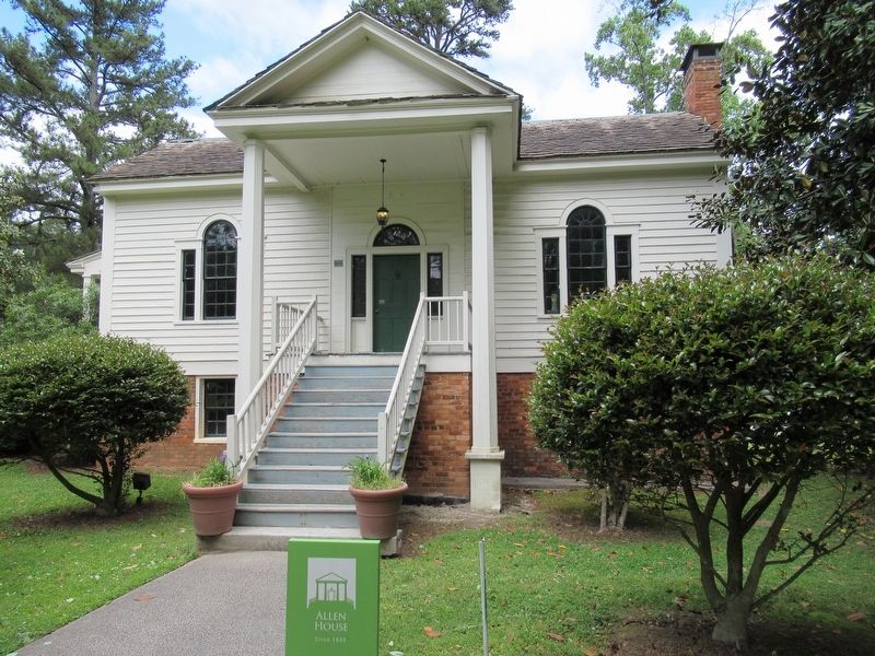
Near John B Gordon Drive 0.1 miles east of Jefferson Davis Drive, on the right when traveling east.
This late Federal Style home has seven rooms on two levels and comfortably housed the Allens, a family of four. It was originally located near the town of Kingston, a railroad boom town in the northwest part of the state. The upper level and the . . . — — Map (db m208334) HM
On West Cherokee Avenue west of North Irwin Street, on the right when traveling west.
(Top side)
At this location in 1937 a group of fifty farmers from surrounding counties
met to establish what is now known as the Georgia Farm Bureau Federation and began to shape the future of Georgia's number one . . . — — Map (db m273727) HM
Near West Main Street (Georgia Route 113) west of South Public Square, on the right when traveling west.
Lawyer; Justice, Georgia Court of Appeals; Chief Justice, Supreme Court of Georgia.
Born September 25, 1946. First African American Lawyer to practice law in Cartersville, Bartow County: and to serve as President of Bartow County Bar Association. . . . — — Map (db m190660) HM
Near West Main Street (Georgia Route 113) west of South Public Square, on the right when traveling west.
Lawyer, politician, businessman. Born Hancock County, Georgia, April 20, 1800. Died Bartow County, Georgia, March 17, 1885. Buried in Oak Hill Cemetery.
Major in U.S. Army during Seminole Wars in 1836. State legislator from Putnam County, . . . — — Map (db m190662) HM
Near West Main Street (Georgia Route 113) west of South Public Square, on the right when traveling west.
Legislator, Georgia Governor.
Born February 16, 1936, Atco, Bartow County, Georgia. Elected member of Georgia House of Representatives from several counties, including Bartow County for 18 years, serving as Chairman of the Appropriations . . . — — Map (db m190667) HM
Near West Main Street (Georgia Route 113) west of South Public Square, on the right when traveling west.
Author. Born Elbert County, Georgia, May 17, 1869; died Atlanta, Georgia, February 7, 1935; buried at "In the Valley", Bartow County, Georgia.
Wrote 28 novels, including "Circuit Rider's Wife," upon which the move "I'd Climb the Highest Mountain" . . . — — Map (db m190666) HM
Near West Main Street (Georgia Route 113) west of South Public Square, on the right when traveling west.
Lawyer, legislator, soldier. Born Savannah, Georgia, September 6, 1816; died Manassas Battlefield, Virginia, July 21, 1861; buried Laurel Grove Cemetery, Savannah, Georgia.
Served two terms in State Legislature and one term in State Senate, from . . . — — Map (db m190659) HM
On Park Street 0.1 miles north of Main Street, on the right when traveling north.
Dedicated in 2007, the Kingston Veterans Monument, vision in 1999 by Mrs. Nellie Margaret Harris Applin, stands in honor of the lives of four hundred brave men and women whom served their country with valor, honor and dignity. This memorial resulted . . . — — Map (db m110317) HM
Initiated in Cartersville Lodge No. 63 on June 2, 1891, passed on June 30, & raised on
Aug. 4, 1891. Was W.M. 1893, 1894, 1899 & 1901. Jr. Grand Warden of the Grand Lodge of GA in 1897 & 1898. Judge of Cartersville City Court, President of City . . . — — Map (db m53015) HM
On Mt. Pleasant Road east of Nally Road, on the right when traveling east.
On this historic site a Baptist Church was established on September 5, 1891, by a group of courageous Mount Pleasant Community citizens. The Church was named Mount Pleasant Baptist Church. The present Church which was built in 1948 stands across the . . . — — Map (db m171193) HM
On Waleska Highway (Georgia Route 140) 0.1 miles west of Deer Lodge Road, on the left when traveling east.
Pine Log Town, located on Pine Log Creek in the flat fields slightly over a half mile east of Oak Hill Church north of GA 140, (in Pine Log, Georgia), extended almost a mile along the creek. The lots were 293, 294, 295,296, 317, 318, 284,and 283, in . . . — — Map (db m13190) HM
Honoring our Heritage
Bartow County, home to Red Top Mountain State Park, has long been known for its wealth of iron ore and other minerals with the greatest number of mineral deposits in the state of Georgia. During the . . . — — Map (db m256411) HM
On North Public Square at West Cherokee Avenue, on the right when traveling south on North Public Square.
Pathways to Freedom: A Story in Every Stitch, by sculptor, Przemyslaw Kordys, was commissioned by the African American Quilt Documentation Project of Bartow County and donated to the City of Cartersville in an unveiling ceremony on May . . . — — Map (db m273626) HM
On U.S. 411 at Pine Log Road (Old Route 140), on the left when traveling north on U.S. 411.
250´ west of this marker stands, Historic Pine Log Methodist Church, Cemetery, tabernacle, and Camp Grounds, established in 1834. The oldest Church in continuous use in Cass/Bartow County. This Church area is on the national Register for Historic . . . — — Map (db m273635) HM
On Euharlee Street at Lanier Drive, on the left when traveling north on Euharlee Street.
In 1900, while Georgia was struggling to organize a system of schools, Taylorsville citizens founded the first free high school in Bartow County. Leaders included W. D. Trippe, Sr.; W. M Dorsey; W. P Harris, Sr.; W. m Trippe; E. O. Davis; L. W. . . . — — Map (db m70985) HM
Near West Main Street (Georgia Route 113) west of South Public Square, on the right when traveling west.
Asa G. Candler, founder of the Coca-Cola Company, moved from Carroll County, Georgia to Cartersville and served as an apprentice to learn the apothecary profession. He studied under Dr. John Best and Dr. William Kirkpatrick between 1870 and 1873 on . . . — — Map (db m190704) HM
On Pine Log Road Northeast west of U.S. 411, on the right when traveling west.
Historic Pine Log Methodist Church, Cemetery, Tabernacle, and Camp Grounds, established in 1834. The oldest Church in continuous use in Cass/Bartow County. This Church area is on the National Register for Historic District.
This sign erected . . . — — Map (db m273633) HM
On Homestead Road at Rex Circle, on the right when traveling west on Homestead Road.
This memorial is dedicated to
the remarkable life of
Melvinia “Mattie” Shields McGruder.
She was born a slave in
South Carolina in 1844.
At age 6 she was brought to
the nearby Shields farm
in what is now
Rex, Clayton County, . . . — — Map (db m227406) HM
On West Cherokee Avenue at North Irwin Street, on the right when traveling west on West Cherokee Avenue.
(Southeast side)
Our Soldiers
(Southwest side)
CSA
Erected by the Daughters of the Confederacy
In honor of the men, of Bartow County who served in the army of the Confederate States of . . . — — Map (db m273859) WM
On North Erwin Street north of West Cherokee Avenue, on the left when traveling north.
(Southwest side)
This shaft of remembrance is a gift from his wife to those he served so long and loved so well
(Southeast side)
William Harrell Felton
Born in Oglethorpe Co. Ga.
June 19,1823,
Died in Cartersville,
Sept. 24, . . . — — Map (db m273735) HM
Near Old Allatoona Road SE 2.9 miles east of Interstate 75.
The Federal defense at Allatoona included a military
service road that crossed the Tennessee Wagon
Road-noted by a star on the map. The Military Service
Road connected the fortified positions of the Eastern
Redoubt to the headquarters of the 4th . . . — — Map (db m142956) HM
On Luna Pier Road at Nothern Avenue, on the right when traveling west on Luna Pier Road.
July 3, 2017 (http://Historymysteryman.com/Sylvania-Ohio-Welcomes-Pretty-Boy-Floyd/) Admin (http://Historymysteryman.com/Author/Admin/)
By Don Radebaugh - Downtown Sylvania, Ohio is all of two blocks. Blink twice and you might miss it; but if . . . — — Map (db m293057) HM
Thin black lines indicate changes in relevance. Between each pair of lines entries are ordered geographically but all have the same relevance.
* Inflectional forms of words are their plurals, singulars, and possessives as well as gramatical tenses and similar variations.