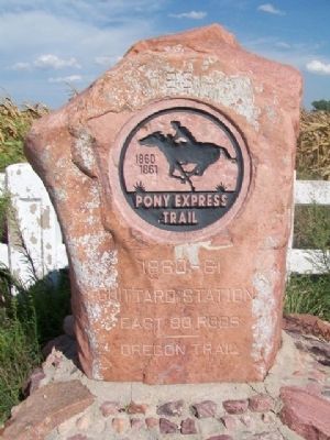
On 21st Road 0.8 miles north of Granite Road, on the right when traveling north.
We spanned the prairie to Guittard's Station, on the far side of a shady, well-wooded creek, the Vermillion... For dinner...the ham and eggs, and hot rolls and coffee were fresh and good, and although drought had killed the salad, we had . . . — — Map (db m77972) HM
On County Road W 500 N west of Road N 225 W, on the right when traveling west.
In 1838 some 800 Potawatomi Indians, being forcibly removed from Marshall County to Kansas, camped along this road, the LaGrange-Logansport State Road. On this “trail of death”, scores of Native Americans suffered and died. The mother of Chief . . . — — Map (db m33812) HM
On Indiana Route 10 at Queen Road, on the right when traveling east on Indiana Route 10. Reported permanently removed.
Pioneer Camp. Here, at twilight on July 26, 1836, after a two-week trip from southern Indiana, Marshall County’s first multi-family group of pioneer settlers made their camp, blowing a conch shell to announce their arrival to Vincent . . . — — Map (db m231887) HM
On Veterans Memorial Drive at Carolina Street, on the right when traveling north on Veterans Memorial Drive.
[Rolls of Honored Dead, Missing,
and Veterans]
————————
In Memory Of
Paul Dwerlkotte
And All Veterans
————————
History
of
the . . . — — Map (db m78044) HM WM
Hollenberg Station and Transportation
By the time Hollenberg Station was begun in 1857 or 1858, Gerat Hollenberg
already had years of experience in operating at road ranch on the Oregon-California Trail. A native of Germany, he had been drawn . . . — — Map (db m253085) HM
On East Bennington Street 0.3 miles west of East Railroad Avenue, on the left when traveling west.
From Farmland to the City of Toluca
In 1887, farmers in Bennington Township of Marshall County were having great difficulty marketing their grain and livestock by horse-drawn wagons to Streator, Peoria or Bloomington. Family diaries even . . . — — Map (db m252916) HM
On William Street north of West Broadway Street, on the right when traveling south.
Prisoners at Alton Military Prison
The Alton Military Prison was inhabited by four different classes of prisoner, Confederates, civilians, Federal soldiers and a group called guerillas or bushwhackers.
Confederate prisoners of war made up . . . — — Map (db m211487) HM
Alcove Spring Park consists of more than 200 acres of native prairie and timber land maintained for the preservation of this historic camping ground on the Oregon-California trail and for the enjoyment of our visitors. The park is owned . . . — — Map (db m79116) HM
On U.S. 75 0.4 miles north of 141st Street, on the right when traveling south.
Prairie Passage
Explore the Route of Discovery from Border to Border
Prairie Passage Route
Experience and enjoy our tallgrass prairie heritage
The Prairie Passage Project is a partnership of . . . — — Map (db m305488) HM
On 161st Street 0.4 miles east of 140th Avenue, on the right when traveling east.
Prairie Passage
Explore the Route of Discovery from Border to Border
Prairie Passage Route
Experience and enjoy our tallgrass prairie heritage
The Prairie Passage Project is a partnership of . . . — — Map (db m305490) HM
Thin black lines indicate changes in relevance. Between each pair of lines entries are ordered geographically but all have the same relevance.
* Inflectional forms of words are their plurals, singulars, and possessives as well as gramatical tenses and similar variations.