Intended for WGP Foundation Historic Transportation markers only. These are typically white on blue, and topped with a semi-circle divided into quadrants, with each quadrant depicting a mode of transportation. Not intended for other WGPF markers that are not part of this series, even if they are transportation-related. Also, they do not need to be part of the larger WGP Foundation general series.
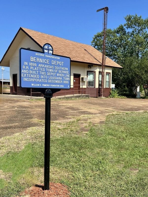
On 4th Street (Louisiana Route 2) at Louisiana Avenue, on the left when traveling east on 4th Street.
In 1899, Arkansas Southern R.R. platted town of Bernice
and built this depot when line extended into Louisiana. Town
incorporated December 1899. — — Map (db m253716) HM
On City Park Drive east of Highland Way, on the right when traveling west.
Last surviving K-2 Pacific type 4-6-2 locomotive steam engine operated by Western Maryland Railway. Built 1912 and retired 1953. — — Map (db m291584) HM
On Fuller Station Road 0.4 miles south of U.S. 20, on the left when traveling south.
NY West Shore & Buffalo RR ran near here 1883. Freight and passenger service from Weehawken, NJ to Buffalo, NY. Later part of CSX system. — — Map (db m280779) HM
On Telephone Road (County Route 159B) east of New York State Route 26, on the right when traveling east.
Est. 1898 by Erie & Central New York RR. In 1907, depot sold, relocated & converted to West Side Grocery Store. Relocated here in 1909. — — Map (db m305533) HM
On Lloyd Street at Prime Street, on the left when traveling east on Lloyd Street.
Sewn by local women in 1873 for aeronaut Samuel A. King. In July 1874, he flew balloon approx. 400 Mi. from Buffalo to New Jersey in 13 Hours. — — Map (db m287225) HM
On Prime Street at Lloyd Street, on the right when traveling south on Prime Street.
Served as commercial center for canal cargo and traders in 1850. William Fargo and Henry Wells began American Express Co. near these docks. — — Map (db m287228) HM
On Prime Street at Hanover Street, on the right when traveling south on Prime Street.
Dug in 1825, ran parallel to Lloyd and Hanover Streets for two blocks connecting Buffalo Harbor and Erie Canal until filled in 1868. — — Map (db m287229) HM
On California Drive south of Milton Street, on the right when traveling south.
Railroad worker housing built by Lehigh Valley RR by 1914. Section foreman Carmine A. Duke resided here with his family 1914-1938. — — Map (db m304953) HM
On Oliver Street 0.1 miles north of Goundry Street.
Brick freight depot completed in 1923 by Erie Railroad. Replaced wood depot burned in 1920. Sold by Conrail 1987 & opened as museum 2003. — — Map (db m280566) HM
On Mechanic Street at Main Street, on the right when traveling east on Mechanic Street.
Opened 1909 by Rochester, Syracuse and Eastern Railroad for electrified line. Closed in 1931. Moved in 1933 and converted to service station. — — Map (db m297416) HM
On New York State Route 43, on the left when traveling east.
Arlington Hotel
previously called the
Elkhorn, was stop 22 on the
Troy & New England railway,
electric trolley from Albia
to Averill Park 1895-1925. — — Map (db m284354) HM
On Wells Avenue near Maple Avenue, on the right when traveling north.
Built 1880 By Middleburgh &
Schoharie RR. 5 - Mile Line
Est. 1867 Ceased Operation
In 1936. Depot later Moved
Here & Rail Yard Became Park.
— — Map (db m278609) HM
On Main Street (New York State Route 213) at 2nd Street, on the right when traveling west on Main Street.
Cable suspension bridge built by John A. Roebling in 1849. Carried D&H Canal over Rondout Creek. Destroyed by fire ca. 1916. 500 ft. north. — — Map (db m303629) HM
On Main Street (New York State Route 213) at 2nd Street, on the right when traveling west on Main Street.
Building constructed 1850 for D&H Canal toll collector. Telegraph office added 1862 when canal company installed lines along the towpath. — — Map (db m303628) HM
On Lawrenceville Road (New York State Route 213) east of Cotterkill Road, on the right when traveling east.
Delaware & Hudson Canal ran through here beginning 1827. Carried passengers & goods including PA coal & Rosendale cement as late as 1917. — — Map (db m303625) HM
On Analomink Street west of South Kistler Street, on the right when traveling east. Reported missing.
Built 1908 by Delaware, Lackawanna & Western RR. Tower operator controlled track switches from here using many mechanical levers. — — Map (db m280383) HM
On West Pennsylvania Avenue east of North Hill Street, on the right when traveling west.
Chartered in 1884. Provided freight & passenger service, connecting Stewartstown to Baltimore, Harrisburg & York. Station built here 1914. — — Map (db m257417) HM
On North Monroe Street at W Summit Pkwy on North Monroe Street.
Driven into former RR bridge running over Monroe St. Bridge Sept. 15, 1914, marking union of two transcontinental RR lines through Spokane. — — Map (db m302926) HM